I am guessing November 30th at Noon.
Actually recapping my earlier efforts this year:
October 13th at noon (nope)
December 17th at noon (unlikely)
Mark

October 20th - October29th.
October 30th - November 6th.
November 7th- November 15th
November 16th - November 24th
November 25th - December 2nd
December 2nd - December 11th
December 12th - December 21st
22nd December - December 31st
Before October 20th
After December 31st

I am guessing November 30th at Noon.
Actually recapping my earlier efforts this year:
October 13th at noon (nope)
December 17th at noon (unlikely)
Mark

There is a little more snow in the forecast from Sunday night through to Tuesday and the temperatures are dropping of late. A visitor to Yosemite asked if the Tioga Pass is likely to open again to which the reply was, "It's possible, but unlikely". If that were the case then it could just be a November 1st closing at 4pm which no one has got close to. Watch this space !
Dave.

If the rain were are currently getting in the Bay Area is any indication of the snow they will be getting in Yosemite...there's going to be a lot with this storm!Originally Posted by Southwest Dave

Utahtea
The latest reports suggest between 5 and 9 inches of new snow on the ground at 8000feet and temps not getting above freezing. The Pass has not re-opened as yet and I am doubting that it will again this season.
Dave.
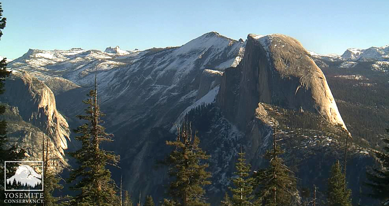
Very little hump is showing....
Photo courtesy of Yosemite Conservancy November 13, 2015 @ 9:20 am PST.
The high country looks set to have more snow through Sunday and the pass remains closed.
Dave.

 RoadTrip Guru & Enthusiast
This morning's Caltrans report says that Sonora Pass is now closed for the winter. Ebbetts, Monitor, and Tioga still just say closed due to snow.
I wonder if they will 'call it' for the season after this next cold front.
On Wednesday the day time temps at around 8500ft are not predicted to get above -8C and into the night a rather cold -17C. Brrrrr. Even in the Valley it is unlikely to get above freezing on Wednesday and snow chains may be required so check the Yosemite NPS site if travelling the area..DAYS TWO THROUGH SEVEN...MONDAY THROUGH SATURDAY
* SNOW ACCUMULATIONS: 2-3 INCHES IN LOWER SIERRA ELEVATIONS AND UP
TO 6 INCHES OVER HIGHER ELEVATIONS.
* ELEVATION: SNOW LEVEL STARTING AT 5500-6000 FEET TUESDAY
AFTERNOON. LOWERING TO 2500-3000 FEET BY WEDNESDAY MORNING.
* WINDS: GUST TO 50 MPH OVER THE SIERRA RIDGES.
* TIMING: STRONG WINDS DEVELOPING AROUND MIDDAY TUESDAY AND
PRECIPITATION STARTING TUESDAY AFTERNOON. SNOW SHOWERS
CONTINUING THROUGH WEDNESDAY.
* LOCATIONS INCLUDE: TUOLUMNE MEADOWS...YOSEMITE VALLEY...EL
PORTAL...FISH CAMP...SHAVER LAKE...HUNTINGTON LAKE.
* IMPACTS: SLICK ROADS DUE TO RAIN AND SNOW. SNOW POSSIBLE FOR THE
LOWER ELEVATIONS WITH TRAVEL DELAYS AND CHAIN CONTROLS.
Dave.
From CalTrans:
"This highway information is the latest reported as of Sunday, November 22, 2015 at 17:18 .
SR 120
[IN THE CENTRAL CALIFORNIA AREA & SIERRA NEVADA]
IS CLOSED FROM CRANE FLAT TO 5 MI WEST OF THE JCT OF US 395 /TIOGA PASS/
(TUOLUMNE, MONO CO) - DUE TO SNOW - MOTORISTS ARE ADVISED TO USE AN ALTERNATE
ROUTE "
Donna
RoadTrip Guru & Enthusiast
Donna, it's been saying that every day since the 1st.
 Posting Permissions