Page 8 of 15 FirstFirst 123456789101112131415 LastLast
Results 71 to 80 of 146
  1. #71
    Join Date
    May 2003
    Location
    Green County, Wisconsin
    Posts
    13,830

    Default too fast

    Geesh, I finally get two pictures that I knew the answers to (Land between Lakes and Arch), and you guys beat me to it.

    I will say that I just stopped at the Elk/Bison range at LBL this spring and it was quite nice, although the Elk were off of the reserve for testing. Certainly worth the couple of buck to get in for a nice break from the road for an hour or so.

  2. #72
    Join Date
    Jan 1998
    Location
    Las Vegas, Nevada
    Posts
    12,996

    Default Wow and double Wow

    Great photos from the lava fields in Hawaii and very fast identification of the healing sanctuary at Chimayo!

    Midwest Michael: Geesh, I finally get two pictures that I knew the answers to (Land between Lakes and Arch), and you guys beat me to it.
    I know, these guys are getting awfully fast on the trigger! Good thing somebody is minding the store while I am off playing....

    Midwest Michael: I will say that I just stopped at the Elk/Bison range at LBL this spring and it was quite nice, although the Elk were off of the reserve for testing.
    I had no idea that one could find bison in Tennessee until I saw Gerald's photo!

    Mark

  3. #73
    Join Date
    Jan 1998
    Location
    Las Vegas, Nevada
    Posts
    12,996

    Default A Scene of Great Controversy

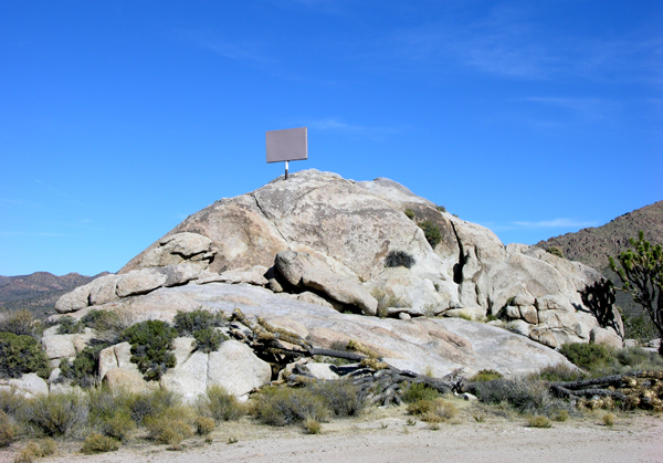
    OK, you wise eagles -- what the heck is this? And where is it?

    (Photo by Mark Sedenquist)

  4. #74

    Default You're too gracious--I missed it!

    Quote Originally Posted by Kestrel View Post
    Close enough.

    The lava is currently entering the ocean outside the boundary of Hawaii Volcanoes National Park. Chain of Craters road ends a dozen miles or so from the entry point.

    This is actually Hawaii state highway 130 coming from the other side of the lava entry. The original highway is under several feet of lava and at one time it did connect to Chain of Craters road. A bit further down the road is a parking area. From there you hike about 3/8 of a mile for this view.


    It's even better at night, when the plume is lit by the lave underneath. You can also see occasional explosions that toss rocks and lava into the air. .

    I should have recognized the apparent direction and angle of the sun implies approach from the north/northeast.

    The only time I was there, November 2005, the Chain of Craters Rd reached the Pacific, turned north, ran just a couple of miles, if that, and ended where the lava had crossed some years before. The NPS had placed a restroom and a lightly developed parking area there. The vent to the ocean, however, was just a mile and a half to the north, if recollection serves. We ventured out around 1/4 mile, but the combination of tropical heat, sharp black rock, very challenging walking, and a tropical downpour every 15 minutes turned us back to our rental Jeep. I'm suprised the vent has moved so much farther north than that!

    What an amazing place for a "reformed geologist" to visit! Thanks for sharing.

    Foy

  5. #75
    Join Date
    May 2003
    Location
    Green County, Wisconsin
    Posts
    13,830

    Default that's not where it is!

    Quote Originally Posted by Mark Sedenquist View Post
    I had no idea that one could find bison in Tennessee until I saw Gerald's photo!

    Mark
    Well, if that photo is from the Elk and Bison Prairie at LBL, then the photo isn't of Tennessee, its Kentucky.

    Although, I believe there are still Bison located in some portions of the Tennessee section of the park.

  6. #76

    Default There's oil in them thar hills......

    Quote Originally Posted by Mark Sedenquist View Post
    OK, you wise eagles -- what the heck is this? And where is it?

    (Photo by Mark Sedenquist)
    I dunno, how about Teapot Dome, Wyoming? My studies and recollection tell me the Teapot Dome is a large-scale geologic structure more readily observed on maps and airphotos than in outcrop. The terrain surrounding the outcrop, and the "controversial" hint still bring me to a SWAG that it's Teapot Dome.

    Foy

  7. #77

    Default

    Quote Originally Posted by Foy View Post
    I should have recognized the apparent direction and angle of the sun implies approach from the north/northeast.

    The only time I was there, November 2005, the Chain of Craters Rd reached the Pacific, turned north, ran just a couple of miles, if that, and ended where the lava had crossed some years before. The NPS had placed a restroom and a lightly developed parking area there. The vent to the ocean, however, was just a mile and a half to the north, if recollection serves. We ventured out around 1/4 mile, but the combination of tropical heat, sharp black rock, very challenging walking, and a tropical downpour every 15 minutes turned us back to our rental Jeep. I'm suprised the vent has moved so much farther north than that!

    What an amazing place for a "reformed geologist" to visit! Thanks for sharing.

    Foy
    It is an incredible place.

    The Hawiian Volcano Observatory maps shows the current ocean entry point. You will also want to look at the images tab on that link. The June 30th collapse event happened while we were hiking on the Devastation trail about a mile away. The ash cloud was obscured by clouds and we thought the rumble was thunder. Didn't know what the noise really was until we got back home and looked at the web page.

  8. #78

    Default Great map!

    I'd plumb forgotten about the USGS station and the frequent updates. That map shows as light tan the 2004-2007 flow field, and a spur way to the left is around 1.5 miles from the end of Chain of Craters Rd, just as I recalled.

    The view as we neared the big drop-off, identifiable by the road's switchback on the map, was surreal and one of the more breathtaking sights I've ever seen. It was overcast, but high overcast. The steam plume was seemingly right at the end of the road, some 1,500' in elevation below and still several miles distant. My wife saw the plume first and said "there must be a forest fire ahead!"

    I'm definitely going back to the Big Island, and will spend at least a week in and around Hawai'i Volcanoes NP, Hilo, and South Point, and another full day on the Mana Road, circumnavigating and ascending Mauna Kea (again). This time, I'll spend more time at the Observatory village at around 8,000', acclimating just a bit. I was fairly woozy at the summit (13,796') in 2005. Not the best of conditions to enjoy it or to drive back down. I rolled down the Jeep windows for a steady blast of cold air and oxygen on the way up and back.

    Come to think of it, I might as well drive up and bag Mauna Loa's summit, too, as long as I'm completely violating my Jeep's rental contract on the Saddle Road, Mana Road, and Mauna Kea. Kids, don't do this at home!

    Thanks again for sharing,

    Foy

  9. #79
    Join Date
    Jan 1998
    Location
    Las Vegas, Nevada
    Posts
    12,996

    Default You're correct and incorrect....

    Quote Originally Posted by Midwest Michael View Post
    Well, if that photo is from the Elk and Bison Prairie at LBL, then the photo isn't of Tennessee, its Kentucky.
    Yep, I mis-identified where along the Trace those two bison were -- according to Gerald's field report he found them just inside the Tennessee line....

    Mark

  10. #80
    Join Date
    Jan 1998
    Location
    Las Vegas, Nevada
    Posts
    12,996

    Default Hint #2 --


    Quote Originally Posted by Foy View Post
    The terrain surrounding the outcrop, and the "controversial" hint still bring me to a SWAG that it's Teapot Dome.
    Foy
    The location of this outcropping is very near the borders of two western states -- but one of them is NOT Wyoming... sorry. This photo was taken in Spring, 2005 -- the source of this controversy is back in the news this month....

    Mark
    Last edited by Mark Sedenquist; 07-15-2009 at 11:20 AM.

Similar Threads

  1. "Where in North America?" --- Section VIII
    By Mark Sedenquist in forum RoadTrip Field Reports
    Replies: 141
    Last Post: 10-24-2009, 09:10 AM
  2. "Where in North America is this?" Section VI
    By Twilight in forum RoadTrip Field Reports
    Replies: 146
    Last Post: 08-30-2009, 02:27 AM
  3. "Where in North America is this?" Section V
    By Mark Sedenquist in forum RoadTrip Field Reports
    Replies: 145
    Last Post: 08-13-2009, 08:38 PM
  4. "Where in North America?" --- Section III
    By Mark Sedenquist in forum RoadTrip Field Reports
    Replies: 278
    Last Post: 07-07-2009, 05:00 PM
  5. "Where in North America?" -- Section I
    By Quebec Gen in forum RoadTrip Field Reports
    Replies: 325
    Last Post: 04-29-2009, 02:34 PM

Tags for this Thread

Posting Permissions

  • You may not post new threads
  • You may not post replies
  • You may not post attachments
  • You may not edit your posts
  •