1. #151
    Join Date
    Jan 1998
    Location
    Las Vegas, Nevada
    Posts
    12,995

    Default I bet it's not what that clue reminded me of....

    Up near Avenue of the Giants is a memorial to Weott, a small town that was wiped out twice by flooding from the South Eel River -- once in 1955 and then again in 1964 -- but I've never seen corn grown there!

    But then.... I got to thinking.... you're clues are always clever.....And then it hit me -- Weed, California is both relatively high in elevation and descriptive... so the town must be Weed and there have some some massive floods in Weed!.

    The highway....Could it be along Old Highway 99?


    Mark

  2. #152
    Join Date
    May 2009
    Location
    SF Bay Area
    Posts
    812

    Default Close enough!

    You were very close with your first thought.

    It's the (former) town of Pepperwood, at the northern end of Avenue of the Giants (old US101).

    The memorial was erected by the Chamber of Commerce of Fortuna.

    Those who visit this area should be on the lookout for old flood markers.... in some cases 10-20 feet above the road. The Eel has been dangerous in the past.

    As for "agricultural products".... the redwoods are the obvious first one; tallest living things. And yes, weed: Humboldt county is also (in)famous for having a second large "cash crop" of vegetable matter; intended to be set on fire and inhaled. Typically not declared on the county ag reports.

    There is something magical about cruising down the Avenue of the Giants in a convertible with the top down, and some classical musing playing (Beethoven's 9th is my favorite).
    Last edited by CalOldBlue; 06-29-2009 at 09:09 PM. Reason: final thoughts

  3. #153
    Join Date
    Jan 1998
    Location
    Las Vegas, Nevada
    Posts
    12,995

    Default I know I've seen the memorial

    Are there two such towns along the Eel River? I've taken photos of people standing under some of the high flow markers...

    And here I thought you were be really clever with Weed!

    Where is the Corn Cob statue and why was it chosen for this memorial? I am still lost. Here's my Avenue of the Giants article and here are some my favorite tunes....

    This makes me think about Cornville, Arizona (which has never been able to grow corn) but was supposed to be named Conville (after the local founding family) but the postal clerk entered the wrong name!

    Mark
    Last edited by Mark Sedenquist; 06-29-2009 at 09:23 PM.

  4. #154
    Join Date
    May 2009
    Location
    SF Bay Area
    Posts
    812

    Default Pepperwood is still there.... sort of

    It is now an unincorporated area on CA254 (A of the G) across the river from Shively. Farming area on the Eel River floodplain (good soil, lousy for permanent habitation). It used to be a real town I guess; post office and everything. Supposedly known for their veggies (including corn), so when the Fortuna lads decided to memorialize the town they chose a corncob. I leave it to your imagination if they were sober/straight at the time.

    The plaque on the memorial reads:

    To Pepperwood
    And It's Loved Ones
    Gone But Not Forgotten
    Presented by
    Fortuna Chamber of Commerce

    The 1955 and 1964 floods pasted most of the towns along the A of G (which WAS US101 back then). Weott (maybe others) rebuilt uphill. Pepperwood didn't bother to rebuild the town, although folk have put houses back up (and some flood control dams have been since added).

    Here's a link to a photo of the effect of the 1955 flood on Pepperwood: http://americahurrah.com/Flood55/Pepperwood.htm

    And the state park page on the Eel floods in general: http://www.parks.ca.gov/?page_id=25896

    Plus a shot of a rebuild of a bridge damaged in the 1964 flood: http://sunnyfortuna.com/railroad/images/2001/may.jpg

    Pepperwood is about a mile south of the northern end of A of G, the memorial is on the east (river) side of the road. Hard to miss.

    Side note: the Russian River, the southward flowing sister of the northward flowing Eel (they drain the coastal mountains between Sonoma County and Humboldt County), also flooded in these two years. With a flood stage of 32 feet it hit 47 feet and change both years.
    Last edited by CalOldBlue; 06-29-2009 at 09:51 PM. Reason: Added Russian River note and bridge pic

  5. #155
    Join Date
    Jan 1998
    Location
    Las Vegas, Nevada
    Posts
    12,995

    Default Sort of an "E Clampus Vitus" memorial?

    Quote Originally Posted by CalOldBlue View Post
    I leave it to your imagination if they were sober/straight at the time.
    Ah, that clears it up -- Yeah, that doesn't require much imagination....

    Mark

  6. #156
    Join Date
    Jan 1998
    Location
    Las Vegas, Nevada
    Posts
    12,995

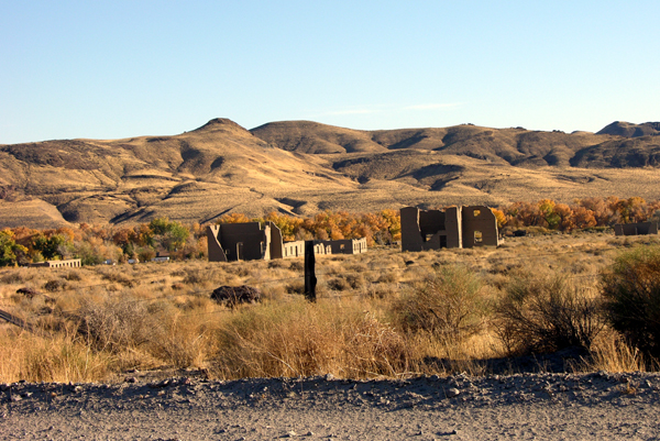
    Default ...And, yes...It's another fort....

    This is a bit tougher, since the topography is harder to recognize, but I can tell you that it is an old fort located west of the Mississippi River... It's located on a river as well....

    Photo by Mark Sedenquist)
    So, what's the name of the fort and why was it placed there?

    {And I keep waiting for Foy to post some of his photos from the Carolinas.....} {And AZBuck with all of his knowledge of the Civil War and Indian Wars, must have some beauts of photos...?}

  7. Default

    Looks like Oklahoma when I spent some time there...

  8. #158

    Default

    Quote Originally Posted by Mark Sedenquist View Post
    {And I keep waiting for Foy to post some of his photos from the Carolinas.....}
    Well, our digitizing program has been OBE (overtaken by events). I've got some really great excuses. Would you care to hear a few?

    I doubt we'll have anything done for at least a month from the present. That said, I've got some terrain shots of a more current nature, from the Carolinas and elsewhere in the East, so I'll see about posting some of those.

    Foy

  9. #159
    Join Date
    Jan 1998
    Location
    Las Vegas, Nevada
    Posts
    12,995

    Default Yeah, it does look like Oklahoma -- Hint #2

    Quote Originally Posted by SLWhitesell View Post
    Looks like Oklahoma when I spent some time there...
    But in this case, it is located west of the Rocky Mountains.... and a longitude on par with ........St. Louis, Missouri.. or so.

    Mark

  10. #160
    Join Date
    Jan 1998
    Location
    Las Vegas, Nevada
    Posts
    12,995

    Default I bet I could match and raise your excuses by one level of difficulty....

    Quote Originally Posted by Foy View Post
    Well, our digitizing program has been OBE (overtaken by events). I've got some really great excuses. Would you care to hear a few?
    Sorry to hear things have turned tough of late -- We continue to be "challenged" by developments here as well. Onward!

    Mark

Similar Threads

  1. "Where in North America?" --- Section VIII
    By Mark Sedenquist in forum RoadTrip Field Reports
    Replies: 141
    Last Post: 10-24-2009, 09:10 AM
  2. "Where in North America is this?" Section VII
    By Mark Sedenquist in forum RoadTrip Field Reports
    Replies: 148
    Last Post: 09-22-2009, 10:00 AM
  3. "Where in North America is this?" Section VI
    By Twilight in forum RoadTrip Field Reports
    Replies: 146
    Last Post: 08-30-2009, 02:27 AM
  4. "Where in North America is this?" Section V
    By Mark Sedenquist in forum RoadTrip Field Reports
    Replies: 145
    Last Post: 08-13-2009, 08:38 PM
  5. "Where in North America?" -- Section I
    By Quebec Gen in forum RoadTrip Field Reports
    Replies: 325
    Last Post: 04-29-2009, 02:34 PM

Tags for this Thread

Posting Permissions

  • You may not post new threads
  • You may not post replies
  • You may not post attachments
  • You may not edit your posts
  •