Topography looks like Anza-Borrego Desert State Park. But not positive.
Mark


Topography looks like Anza-Borrego Desert State Park. But not positive.
Mark
Actually, that one rock looks like the final campground of Gram Parsons (where he died) in Joshua Tree National Park. It seems like I've been here.. But I can't quite place it.
This photo looks similar to the rock outcropping known as "Loose Lady" in the park.
Mark

The area looks familiar for a reason which will become apparent when the name of location is revealed!
My clue to "Where I Am" is this picture and probably all that's needed. Name the mountains!
Here's another great shot. Can you name the arch?
Utahtea

Another here that thought it looked familiar ! You are in the Alabama hills just west of Lone Pine and that is Mobius arch. The trail starts along Movie Flats road, named so as this location has been used in many movie scenes. We spent a great night here in an RV with amazing night skys. Oh yeah, that's the southern Sierras and Mt Whitney in the background.
Dave.

I haven't been there, but that thing is a Mobius Arch if ever I saw one!Originally Posted by Southwest Dave

I love your pictures, Utahtea, so much that I took the liberty of waving my magic wand over this one:
I'll have to add this place to my list!
Rick
YES, Dave is the winner! So many westerns and other movies have been filmed in this location like Tremors...which we watched that evening in the RV. It turns out it was also filmed on the Highway we took before the turn off to Cerro Gordo! I had been wanting to visit for years but it just never fit an itinerary so last Feb. we made it part of the itinerary before we entered Death Valley! I don't have names for all the locations but I will name the ones I know below.
This is one of the location where Bunga Din with Cary Grant was filmed in 1938! This is the temple site
This is Heart Arch
LOL...we got turned around from our map and not sure where were were at this point!
It's a bad angle but right in the center of this picture is the Eye of The Alabama Arch
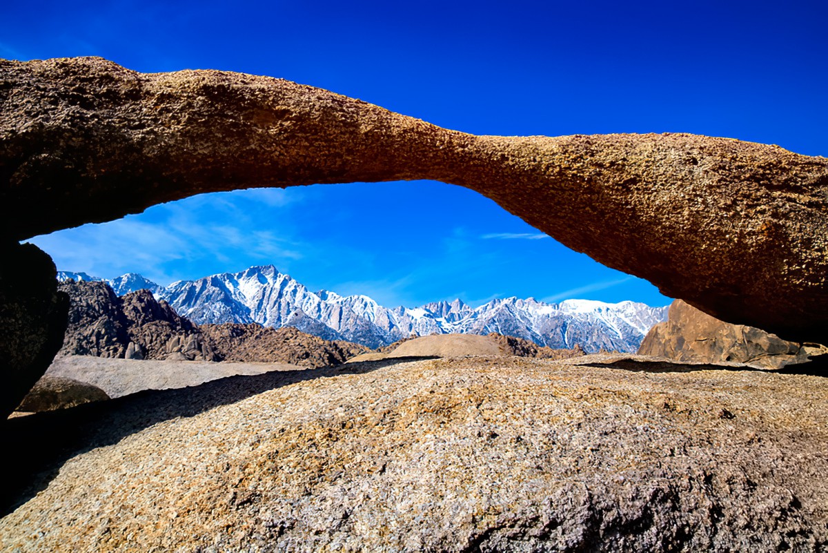
Lathe Arch - which is very deceiving because it's very small but makes a great frame of the Eastern Sierra mountains. Lone Pine peak is in this picture.
Here is Lathe Arch with people in the photo!
Mobius Arch which much larger than the Lathe Arch. I stood up inside this one.
Utahtea
Last edited by Mark Sedenquist; 07-04-2020 at 02:10 PM. Reason: removed errant tag
You are going to have to tell me what software you use to edit. I have two but not thrilled with either of them. This is actually Lathe Arch which is near Mobius Arch. In fact if you are hiking and not paying attention you can miss this arch very easily! See my previous post for a better angle of how big this arch really is!
Utahtea
More photos and information from the Alabama Hills area.
The Lone Pine Movie Museum
Photos of the area captured by Southwest Dave!
So many cool roads in the area. Have taken the time to drive to the end of road on the Olivas Ranch Road?
Mark
We spent 4 nights and 3 full days in the Lone Pine area so we had plenty of time to roam around. We also visited Manzanar Historic site, ate at the Alabama Hills Cafe (YUM), stocked up on some groceries before heading into Death Valley at the grocery store, went to the near by charcoal kilns & visited Cerro Gordo Ghost town. What I really wanted to do the most was visit the Little Petroglyph Canyon but they didn't start tours until later in the spring. More than likely didn't even happen this year. There is so much to do in the area!
Utahtea
Yeah, that is an amazing site. I have a bunch of photos from there. I will to dig them out. As you probably know, Little Petroglyph Canyon is in the China Lake Naval Reserve base and so everyone who applies to see the petroglyphs undergoes a background security check.
And the MPs do a very through examination of all cars who enter the base to go and see the etchings. Also, the route to the area passes through a drone bombing range and so everyone and I do mean EVERYONE TURNS OFF THEIR CELL PHONES when passing through that range. It turns out that drones often target devices that operate in the cellular range. Our Navy escorts made sure that we all shut-off our devices until we reached the safety zone.
A pretty fun day!
Mark
 Posting Permissions

 Reply With Quote