View Poll Results: When will Tioga Pass open IN 2018

Voters
13. You may not vote on this poll
  • Before May 1st

    0 0%
  • Between May 1st and May 8th.

    3 23.08%
  • Between May 9th and May 16th

    5 38.46%
  • Between May 17th and May 24th

    2 15.38%
  • Between May 25th and June 1st

    3 23.08%
  • June 2nd and June 9th.

    0 0%
  • Between June 10th and 20th

    0 0%
  • After June 20th

    0 0%
Multiple Choice Poll.
Page 5 of 5 FirstFirst 12345
Results 41 to 50 of 50
  1. #41
    Join Date
    Jul 2007
    Location
    South of England.
    Posts
    12,173

    Default

    Better than eating ice cream.
    Wow ! That is amazing ! Hehe.

    You should be fine, I don't think there has been a permanent closure for the season during September, certainly not in recent times. As you get towards October there is a risk of temporary closures which can be due to freezing overnight temperatures icing the road. We had to wait until lunchtime for it to open during one October as the sun went to work on thawing it out.

  2. Default Driving Tioga Pass on Tuesday, 5/22/2018 - the day after it opened

    I drove Tioga Pass and Highway 120 through Yosemite yesterday and will mostly let the pictures tell the story. I skied at Mammoth from 7:40 to about 11:45 with a break around 9 to sit out some very dense and wet fog that brought mixed precipitation at 10K', but was all rain at current ~9K' bottom of ski area. Snow was good early, but the moisture and warming temps made it sticky in most places. I was on 395 N before noon and stopped at Whoa Nellie Deli (highly recommended) at base of Tioga for an order of carnitas tacos.
    5986TiogaPassOpenBaseSign.jpg5987WhoaNellieDeliTacosMonoLake.jpg5988TiogaPassGas.jpg
    I ate one there, with a view of Mono Lake, then my last stop in the Park was at a picnic area next to Yosemite Creek where I had another half taco and the rest of the beans with some chips at a table next to roaring creek. Weather was on and off drizzle. I did not buy any expensive fuel at the base of the Pass. I had filled up in Minden, NV ($3.149 for regular at Arco) and made it to Mammoth, then home to San Jose (400 miles) before re[fueling at Costco today.
    1836YosemiteCreekPicnic.jpg
    There was not that much snow in most places on Tioga Pass and I don't remember seeing any around Olmstead Point. This picture is parking lot for bathroom by entrance station. The eight beer cans melting out from under the snow came home with me.
    6038TiogaPassSnowGarbage.jpg
    Last edited by tseeb; 05-23-2018 at 07:29 PM. Reason: clarity

  3. Default

    I'm continuing in another post as I ran into the five picture limit. I stopped at Tenaya Lake and took the first picture with my phone that ran out space so the next and rest of the pictures are from my camera. The second picture of the Lake was taken while driving as a tour bus was coming and I did not want to get stuck behind it.
    6039TenayaLake.jpg1826TenayaLakeDriveBy.jpg

    The rest of the pictures I'm posting were taken from Olmstead Point. One is looking one way towards Half Dome which was partially in clouds and one is looking back towards Tenaya Lake.
    1828HalfDomeZoom.jpg1833Highway120TenayaLake.jpg
    Last edited by tseeb; 05-23-2018 at 03:08 PM. Reason: formatting

  4. #44
    Join Date
    Jul 2007
    Location
    South of England.
    Posts
    12,173

    Default Thanks !

    Nice pictures thanks for sharing them with us.

    Dave.

  5. Default

    A couple of more pictures from Olmstead Point. One is of some people hiking on the granite near the somewhat busy, but not nearly full, parking area. There is a lot of granite across the highway with even better views and, as long as it is not wet and you have decent shoes, it has very good traction.
    1830OlmsteadPoint.jpg1835HalfDome.jpg
    The last picture is another of Half Dome which I have day-hiked to the top twice. I also have day-hiked from near Tenaya Lake to Clouds Rest which is higher than and overlooks Half Dome and does not require a permit as Half Dome does when cables are up. Both hikes are between 15 and 20 miles round trip depending on route and include a lot of elevation gain and loss and are not to be taken lightly or without some training.

    I did not stop much this trip as I needed to make a stop in Stockton before a business closed and I was tired from a lot of driving and skiing over three days. But now that I have my Senior Parks pass, I hope to return soon and do more exploring.

  6. #46
    Join Date
    Nov 2009
    Location
    Brisbane, Queensland, Australia, Australia
    Posts
    232

    Default

    Quote Originally Posted by Southwest Dave View Post
    Wow ! That is amazing ! Hehe.

    You should be fine.
    Thanks Dave. :) I better get my A into G and start planning. Time is going by to quickly.

  7. Default

    I found a few more pictures from the East side of Tioga Pass to share. First one is going up the pass at about 8K' level with another 2K' to go.
    5990GoingUpTioga.jpg
    Ellery Lake and 13,061' Mt Dana which some people hike up from the pass, then ski down to this lake or come out further down highway if there is enough snow. This is the picture that made me do another reply to this thread.
    6035ElleryLakeMtDana.jpg
    A couple of crops of same picture of the Tioga Pass entrance station into Yosemite taken through my windshield while waiting for two vehicles ahead of me. This is the highest trans-Sierra pass in CA, but not the highest paved road.
    6037TiogaEntrance2Yosemite.jpg6037TiogaEntrance2Yosemite2.jpg

  8. #48
    Join Date
    Jul 2007
    Location
    South of England.
    Posts
    12,173

    Default Cool.

    Thanks for posting these pictures. It just makes me want to go back and drive it again even more !

    Dave.

  9. #49
    Join Date
    Jan 1998
    Location
    Las Vegas, Nevada
    Posts
    13,016

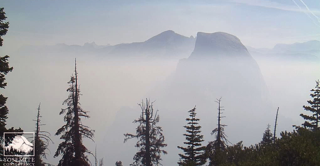
    Default It is very smoky in Yosemite Valley

    The Ferguson Fire along CA State Highway 140 is blanketing Yosemite Valley in smoke today:


    Photo courtesy of The Yosemite Conservancy.

    More news here:

    SF Curbed.com

    Wildfire Today.
    Last edited by Mark Sedenquist; 07-18-2018 at 02:17 PM.

  10. #50
    Join Date
    May 2011
    Location
    Central Missouri
    Posts
    5,943

    Default

    Having run into a similar situation up in Olympic National Park last summer, I certainly feel sorry for all the folks trying to visit Yosemite with this smoke. Unfortunately, "California" and "fires" together in the same sentence, is so common that it's almost scary. Right before we got home, there was a large fire in our East County, Alpine area.

    Utah currently has a high fire danger. Last week, we saw signs to that effect. While in Cedar Breaks, which had a "no fires except for camping stoves" rule, a ranger told a man not to light up that cigarette. Evidently, cigarettes were also banned. Not even supposed to light up in your own car, because (as most of us know) too many people throw the butt out the window.


    Donna

Similar Threads

  1. Competition: Tioga Pass Prognosticator 24. Winter closing.
    By Southwest Dave in forum Memorable Breakdowns & Back Roads
    Replies: 41
    Last Post: 02-09-2018, 03:10 PM
  2. Competition. Tioga Pass Prognosticator 23. Spring Opening 2017.
    By Southwest Dave in forum Memorable Breakdowns & Back Roads
    Replies: 64
    Last Post: 09-23-2017, 04:23 AM
  3. Tioga Pass Prognosticator 19. 2015 Spring Opening.
    By Southwest Dave in forum Memorable Breakdowns & Back Roads
    Replies: 70
    Last Post: 07-24-2015, 06:14 AM
  4. Spring Rite of Passage: Tioga Pass Prognosticator #11
    By Mark Sedenquist in forum Memorable Breakdowns & Back Roads
    Replies: 131
    Last Post: 06-24-2011, 11:56 PM
  5. Warm Spring = Early Opening of Tioga Pass!
    By Mark Sedenquist in forum Planning Summer RoadTrips
    Replies: 0
    Last Post: 05-03-2004, 10:30 AM

Tags for this Thread

Posting Permissions

  • You may not post new threads
  • You may not post replies
  • You may not post attachments
  • You may not edit your posts
  •