Page 3 of 4 FirstFirst 1234 LastLast
Results 21 to 30 of 37
  1. #21

    Default Sequoia & Kings Canyon NP - Day 13

    Saturday, March 28, 2015

    Start & Finish: Buckeye Flats campground, Sequoia National Park


    Click here for this RTA Library Map

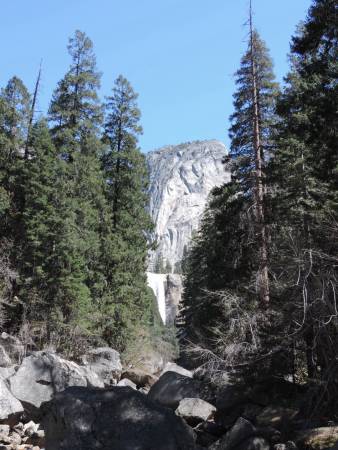
    Very late morning in camp, enjoyable weather and quiet surroundings. Shortly before noon we left camp and drove across Sequoia National Park into Kings Canyon National Park. We stopped at Giant Forest Museum for passport stamp and to walk the Tall Trees trail.

    Tall Trees trail at Sequoia National Park


    We stopped for a picnic lunch along the way, much cooler even in the early afternoon. The lack of snow in the Sierras is evident and part of the severe drought throughout the state. We saw a few patches along the road, but nothing significant. Even the high peaks of the Sierras had some snow, but much less than normal for this time of year.

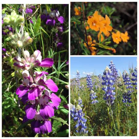
    On the way back to camp we stopped for a few flower pictures of flowers I had spotted on the way up.

    Flowers of the day


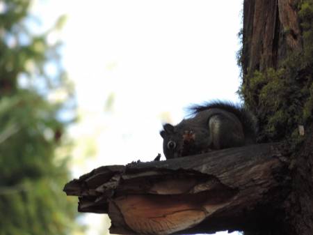
    Back at camp a short trail went up canyon and crossed the Middle Fork Kaweah River. More flowers along the way and a squirrel posed before reaching the rushing water. We heard birds around camp, but the foliage made it difficult to see and identify. We definitely prefer the desert environment for bird watching.

    Tree squirrel


    Middle Fork of Kaweah River


    Passport Stamp
    Sequoia National Park - Giant Forest, CA
    Kings Canyon National Park - Grant Grove, CA

    Wildlife sightings
    Fox Squirrel
    Ground Squirrel
    Lizard

    Dark-eyed Junco
    Common Raven
    Last edited by Tom_H007; 03-11-2019 at 03:32 PM. Reason: Added map

  2. #22

    Default Sequoia NP to w of Yosemite NP, Day 14

    Sunday Match 29, 2015
    Start: Buckeye Flats campground, Sequoia NP
    Finish: El Portal, CA

    '
    Click here for this RTA Library Map

    Not as quiet a night and morning in the campground as the night before, as new neighbors were much noisier on Saturday evening. First time ever we had a problem in a campground; when we returned to camp Saturday afternoon the new neighbors had moved in and were setting up camp in our area and had a car parked in our slot. The yellow tag indicating we had paid through Sunday was replaced with their tag. Our lawn chairs and cooking items in the bear box were in place. Luckily when we pulled in and inquired about the car they readily admitted it was theirs and moved everything off our site. We are still not sure what they thought allowed them to occupy our site. This campground is isolated, no host or rangers are nearby and the campground was full. In the future we might take a photo of our tag showing the permit number and dates. We'll also pull out our laminated 'campsite occupied' tag.


    After breakfast we headed back down into Visalia and north on CA 99 towards Fresno. Before reaching Fresno, in the small burg of Traver, is a real tourist stop, Bravo Cheese. We walked through the gift shop and into the back patio. Lots of relics laying around, including a good old push mover, which kids were pushing around the yard area. Brought back memories of cutting our lawn with a push mower, my father's idea of honest labor. In another area there were at least 10-15 Tonka trucks out for kids to use. Lots of snack, food and drink choices in a small area. Well worth a stop if traveling CA 99. They have a newer version along I-5. Their sign, I think, is appropriate for many roadside attractions.


    Bravo Cheese


    We stopped for gas and lunch before continuing north and eventually heading east on CA 140 towards Yosemite National Park. We knew there were no reservable sites in Yosemite (had checked back several months ago and during the past week for cancellations) and did not want to arrive too late for the 'first come, first served' campgrounds in the park. Most of the Forest Service campgrounds have not opened at this time and we needed showers. We stopped at Indian Flats RV park, just west of El Portal. For $20 we got a shady spot and showers. The drive in along the Merced River is very scenic. This is a route we have seldom used so we enjoyed the 'newness'. It continues to be quite warm, in the upper 80s, but great sleeping weather.


    More birds seen outside of Sequoia and at our campsite tonight.


    Merced River


    Wildlife Sightings


    Rock Squirrel
    Lizard
    Swallowtail butterfly


    Hummingbird
    Turkey Vulture
    Red-tailed Hawk
    Western Kingbird
    Common Raven
    Western Scrub Jay
    Black Phoebe
    Swallow
    American Robin
    Common Poorwill - heard
    Last edited by Tom_H007; 03-11-2019 at 03:49 PM. Reason: Added map

  3. #23

    Default Yosemite NP to Placerville, CA, Day 15 & 16

    Monday, March 30, 2015
    Start: El Portal, CA
    Finish: Hodgdon Meadow Campground (NPS), Yosemite NP


    Tuesday, March 31, 2015
    Start: Hodgdon Meadow Campground (NPS), Yosemite NP
    Finish: Placerville, CA


    Click here for this RTA Library Map

    Monday
    Within a few minutes of leaving the campground we had entered Yosemite National Park on CA 140 and as we were approaching the entrance station around 10 AM traffic was backed up, even before you could see the booth. We thought it was due to Spring Break crowds, but after 15 minutes of stop and go we found out an 18 wheeler was stuck in Arch Rock, just beyond the entrance station. Not stuck because of height, but because of length, couldn't make the small angled turn at the end. Rangers were coordinating one -way traffic on the outbound side. Busy in the valley, but not too busy.


    Backup at Arch Rock


    After stops at the post office for hand cancellation of postcards and the visitor center for passport stamps and more postcards we headed up to Happy Isles trailhead. I hiked up to the bridge at the base of Vernal Falls. It was predicted to,be 81 degrees in the valley, the warmth was causing rapid snow melt. For the past several days large clouds formed over the top of the Sierras, almost looking like summer storm clouds. We were told the rapid evaporation of the snow was forming these clouds.


    Vernal Falls


    Driving along the valley floor the only flowers seen were redbuds and dogwood.
    Dogwood


    As all campgrounds were full on the valley floor, as expected, we head up and out the Northern Yosemite Highway, CA 120, to the last campground, Hodgdon Meadow, at the edge of the park. Lots of sites available, mainly for tent campers, but we found one on the outer edge and enjoyed a relaxing evening.


    18 wheeler post-script
    As we drove up the road out of the valley we came up behind the same 18-wheeler that had been stuck in Arch Rock at the beginning of the day. He was waiting for road construction crews to move pylons from the middle of the 3 tunnels road construction crews had in place for ongoing work. His trailer was too tall to fit in the right lane only. Looks like he would be waiting a while for this next step, we had to drive around him. I think this defines - a bad day at work, and on a Monday!


    Tuesday, March 31


    Campground squirrel


    We made our hot beverages before leaving camp and stopped at Buck Medows for a tasty breakfast. This was a travel day to our son's place in Placerville on a route we have covered multiple times. At Chinese Camp we turned north on CA 49 and made stops at Columbia State Park, a historic mining district you can walk through ( no fee) and in Jackson for some antiquing. Except for Thursday, when we go into San Francisco to start back in the Anza NHT from the northern terminus, we'll be spending time with family until next Sunday. I'll start posting again, at that time.


    Passport Stamps
    Yosemite National Park
    -125th Anniversary 1890 - 2015
    - Yosemite Valley


    Bonus
    Half Dome pictorial
    Columbia State park
    - gold panner pictorial


    Wildlife Sightings
    Mule Deer
    Swallowtail butterfly
    Rock Squirrel
    Fox Squirrel


    Common Raven
    Black Phoebe
    American Robin
    Stellar Jay
    Turkey Vulture
    Wild Turkey
    Acorn Woodpecker
    House Sparrow
    Last edited by Tom_H007; 03-11-2019 at 04:19 PM. Reason: Added map

  4. #24
    Join Date
    May 2011
    Location
    Central Missouri
    Posts
    5,941

    Default

    Two thoughts here:

    When we were tent-camping, we'd occasionally see people who had a "Campsite Occupied" sign made from the metal of an old election sign, the kind you just stick into the ground. It didn't take up much room in their truck camper at all, and came in very handy when they'd leave for the day. Others would pitch a small tent that they would use to stash their lawn chairs.

    Second thought - we'd have loved to have seen a photo of that "stuck 18-wheeler". I read this post aloud to my ex-commercial driver husband, and his comment was, "He's stuck between a rock and a hard place." Then, "didn't he use his trucker atlas? That's not a recommended truck route!"


    Donna

  5. #25

    Default San Francisco & Anza NHT, Day 18

    April 2, 2015
    Start & Finish: Placerville, CA


    Click here for this RTA Library Map

    This day had been well planned in advance in order to have our son chauffeur us into San Francisco (SF) and coordinated with the NPS staff at the Juan Bautista de Anza National Historic Trail ( Anza NHT) office. In order to get the passport stamp at their office, in the heart of the financial district, you need to contact them in advance, they have limited staffing with multiple responsibilities.


    I had rented a smaller car for the few days we were visiting, we were given a Kia Soul, perfect size for our adventures. Our son has lived in San Francisco and did deliveries for a dental office while in college, so he knew the city well. We left Placerville by 6:30 AM and made a couple of pit stops for food & fuel. With 3 of us we were able to make use of the carpool lanes, which require a minimum of 3 as you get closer to the city. Based on the traffic we soared by, it saved us a lot of time. The Bay bridge which connects Oakland to SF is a new bridge with additional lanes, ae nice modern design.


    Our first stop was the Anza NHT office at Bush & Market, we arrived by 10 AM. We parked several blocks away in a public garage and enjoyed the walk after the drive into town. We met with Naomi Torres, Anza Trail Superintendent, who greeted us enthusiastically and provided us with lots of resources. While there we got the office stamp and a stamp that travels on the Coast Starlight, an AMTRAK train that is staffed with NPS employees or volunteers and runs from San Jose to Santa Barbara. It was off season at this time, we had planned to take the train for that stretch and will next time we are in the area when it is running. When collecting passport stamps you learn to get the stamps when you can.


    Stamping in the office


    Next stop was the Mission Dolores, the oldest continuously inhabited building in SF. Parking was non-existent so our son dropped us off in front while we went into the gift shop for the stamp. This was a site we had visited previously, before a stamp was available. While in the neighborhood we picked up sandwiches to go at the local Bi-Rite Market - very tasty Cuban pork with pickled carrots, jalapeņos and cilantro. Our son seems to know ALL of the eating hot spots. The next stop was the Mission USPS for my husband to get a postal cancellation of an envelope with the Dolores Mission passport cancellation. He is creating postal caches of park passport stamps with the closest post office cancellation to the park site. This was another drop and drive around.


    Our next stop was the Presidio - a great location across town which was a military installation that has now been turned into multiple uses, both private and public. We have seen the development over the years and love to see the activity all over the area. The barracks building next to the visitor center for the Presidio is a Walt Disney museum. In the center parade grounds a set up was being done for a large public picnic for the upcoming weekend.


    We have been to SF many times over the years, but today was the best weather of all visits, 70 degrees and clear!


    Now our travels get a bit more complicated, so I will focus on our stop at the new Golden Gate Bridge pavilion, a visitor center directly next to the toll plaza on the south end of the bridge. It is worth a visit, but I highly recommend you take mass transit; either a commercial hop-on, hop-off or city bus or rental bicycle. It is difficult to drive to and there is very little public parking. Again we had a priceless resource - chauffeur son. While at the pavilion I was fortunate to meet up with NPS Ranger Hale. We had been e-mailing back and forth for several months and he had planned to be at the office when we visited. Today, April 2, was the national kick-off of the NPS's centennial project titled "#find your park". Ranger Hale was at the pavilion to interact with the pubic about this program so we were able to spend some time talking and he had me Skype with a ranger at Grand Teton NP ( where we hope to visit in the late summer).


    We made a couple of more stops along the waterfront, including the newly renovated Warming Hut which has an exceptional bookstore and cafe. The last stop was at the Maritime Museum, near Fisherman's Wharf. As this was the week leading up to Easter and many people were enjoying Spring Break, it was very busy.


    Our longest traffic delay was getting back onto the Bay Bridge, and we even were using the carpool route. Unbelievable that many people so this commute daily! We stopped at the Peralta Hacienda, another Anza NHT, in Oakland. We then did some touring of Oakland and Berkley to wait out the bulk of the evening rush hour. We enjoyed a great Chinese meal at Ranch Market 99, near the freeway. With a few more stops including evening refreshments in Sacramento we were back in Placerville by 9 PM. A crazy, fun day!


    Footnote-
    On Friday we went to South Lake Tahoe where the weather was just as spectacular. I couldn't help but contrast the two days!


    Passport Stamps
    Juan Bautista de Anza Nat'l Historic Trail
    Coast Starlight
    AZ-CA
    Mission Dolores
    Presidio de San Francisco
    Golden Gate Bridge
    Peralta Hacienda
    Golden Gate Nat'l Rec Area - Presidio of San Francisco, CA
    Golden Gate Bridge 75th Anniversary 1927 - 2012 - San Francisco, CA
    Golden Gate Nat'l Rec Area Crissy Field - San Francisco, CA
    Bonus
    Pictorial of Presidio
    Pictorial of Golden Gate Bridge
    Golden Gate Bridge - San Francisco, Ca with bridge in center.
    Last edited by Tom_H007; 03-13-2019 at 01:43 PM. Reason: Corrected the spelling of “California”. Had been “Californiaa” in one case.

  6. #26

    Default Back on the Anza NHT- southbound, Day 21

    Sunday, April 5, 2015
    Start: Placerville, CA
    Finish: Pinnacles National Park campground (NPS)


    Click here for this RTA Library Map

    Today was our first day of rain as we left Placerville and started our trip south. Our first stop was in Martinez, CA at the John Muir National Historic Site, a very favorite stop. We have been here many times before, as we greatly admire John Muir! It was raining pretty hard at this point so we watched the video, and as always happens learned several new things about him and his life.

    We left I-680 in San Jose and continued south on US 101, traffic was relatively light and the rain was letting up. We left 101 and drove into San Juan Bautista to visit the state historic park. This was another repeat visit for us. On a previous visit we enjoyed a picnic lunch at a garden in the park and were entertained by a lively flock of chickens. Today the area was very busy as the mission attached to the park is still active, especially on this Easter Sunday.

    San Juan Bautista State Historic Park


    Very large Pepper tree


    We continued west on CA 156 to Hollister, the south on CA 25, a beautiful, twisty drive through a valley in which the San Andreas fault runs. We arrived at Pinnacles National Park around 3:30 and found the parking lot packed. It is a very popular destination at this time of year, luckily campsites were available, for at least one night. It had stopped raining, but was forecast to get close to freezing so we got a site with electric. This had previously been a private campground outside the park boundaries, but was added in recent years. There is also a swimming pool which is available seasonally (opened April 1) and includes showers.

    It was nice to enjoy the wildlife in the campground. In addition to watching the squirrel family we were able to watch a California Condor soar over the ridge behind us. And as the sun was setting we watched the turkey vultures roost in a nearby pine tree, up to 30 in the same tree.

    Pinnacles National Park campground critters


    Passport Stamps
    John Muir NHS - Martinez, CA
    Juan Bautista de Anza NHT
    -John Muir NHS
    -San Juan Bautista SHP

    Bonus
    John Muir quote "the clearest way into the Universe is through a forest wilderness"
    3 different pictorial stamps at San Juan Bautista SHP

    Wildlife Sightings
    Rock Squirrel

    Western Scrub Jay
    Acorn Woodpecker
    Wild Turkey
    Great Egret
    American Coot
    Canada Geese
    Turkey Vulture
    Common Raven
    Brewer's Blackbird
    Steller's Jay
    Cooper's Hawk
    Mourning Dove
    California Quail
    House Finch
    Northern Flicker - Red-shafted
    California Condor
    Last edited by Tom_H007; 03-13-2019 at 01:44 PM. Reason: Added map

  7. #27

    Default San Francisco photos, Day 18

    Thursday, April 2, 2015


    I just received some photos taken by NPS staff while we were in San Francisco.


    #find you park Kick -off at Golden Gate Bridge Pavilion - Skype with Grand Teton NP
    bottom section - stamping my Anza NHT Junior Ranger certificate


    My husband and I with Ranger Hale at Golden Gate Bridge Pavilion

    Like I said in the original post - the weather was spectacular!

  8. #28

    Default US 101 Southbound, Day 22

    Monday, April 6, 2015
    Start : Pinnacles NP
    Finish: Cerro Alto campground (USFS), w of Atascadero, CA


    Click here for this RTA Library Map

    Very cold morning at Pinnacles NP, frost on the chairs and table we left outside. Toasty inside when we turned on the electric heater an hour before we ventured out. Before leaving the park we drove up the road into the park for a view of the Pinnacles, the morning light added color to the rocks.


    Pinnacles NP


    As we left the park we saw a large group of Wild Turkeys, with a number of males in full feathers.


    We continued south on CA 25, a beautiful drive through a valley. A side road turned off and headed west into King City. There we crossed over US 101 and followed the Jolon Road up to the San Antonio Mission, another stop along the Anza NHT. The mission was built in 1771 and Anza and his group stopped there on their way north. The grounds surrounding the mission are very well kept with plenty of historical and archaeological signs.


    Adobe ruin along Jolon Road


    Mission San Antonio


    As we followed Jolon Rd back south to US 101 at Bradley we spotted a herd of Elk. And we watched a Prairie Falcon hover in the sky, move a bit and then continue to hover. It dove several times, but never came back up with anything. Lots of lupine and some cold poppies in the fields. The sun had been out all morning, but the poppies were still closed up.


    Elk herd


    Our next stop was to be in Atascadero for the next Anza NHT, however as we went through Paso Robles, and it was lunch time, we stopped at Firestone-Walker Brewery for a delicious lunch and tasty IPA. Then we stopped in Atascadero at the Atascadero Mutual Water Company, the holders of the Anza NHT passport stamp. Unique place for the stamp, but the staff was pleasant and had the stamp readily available with relevant literature at hand. A section of the trail that the NPS has verified that Anza's expedition took has been developed along the Salinas River by the water company and other local groups. We picked up the trail map and went over to the area for a short hike along this section of trail. Afterwards we stayed in town and found several letterboxers placed by planters we know, but who live out of the area. We really enjoyed our time spent in Atascadero. In the past we have visited the Charles Paddock Zoo which is very well done for a small zoo.


    Lizard along the Anza NHT


    North of town my husband checked out Vineyards Antiques while I got caught up on transferring pictures and posting to RTA. We then took CA 41 west, about 8 miles out of town to Cerro Alto campground. We have stayed here before and enjoy the dense coastal mountain canyon it is in, just watch out for the abundant poison oak! Quiet night in camp, waiting for the predicted rain.


    Flowers


    Passport Stamps
    Juan Bautista de Anza NHT
    -Mission San Antonio
    -Atascadero, CA

    Wildlife Sightings
    Rock Squirrel
    Elk
    Mule Deer

    Turkey Vulture
    Brewer's Blackbird
    Steller's Jay
    Cooper's Hawk
    Wild Turkey
    Common Raven
    Yellow-billed Magpie
    Mourning Dove
    Western Kingbird
    Western Meadowlark
    California Quail
    Rock Pigeon
    American Coot
    Prairie Falcon
    Red-tailed Hawk
    American Robin
    Dark-eyed Junco
    Last edited by Mark Sedenquist; 03-16-2019 at 07:19 PM. Reason: Added map

  9. #29

    Default

    Hi Pat,

    In the past year or so I have really enjoyed reading your trip reports, so I thank you for them. Interesting, educational and very often beautiful.

    When I have more time to spare (hopefully in the not so distant future), I would love to travel through many states, but Arizona and a couple of others in particular, at a slow pace.

    Your reports certainly keep fuelling that fantasy!

    Subman

  10. #30

    Default

    Quote Originally Posted by Subman View Post
    Hi Pat,

    In the past year or so I have really enjoyed reading your trip reports, so I thank you for them. Interesting, educational and very often beautiful.

    When I have more time to spare (hopefully in the not so distant future), I would love to travel through many states, but Arizona and a couple of others in particular, at a slow pace.

    Your reports certainly keep fuelling that fantasy!

    Subman
    I know our slower and off-the-beaten path trips are not the main focus for many of the travellers who use this website, but hopefully our adventures bring some pleasure and help to all who travel.
    Thank you for your kinds words. I hope your wish comes true soon!
    -Pat

Similar Threads

  1. Tioga Pass Prognosticator 19. 2015 Spring Opening.
    By Southwest Dave in forum Memorable Breakdowns & Back Roads
    Replies: 70
    Last Post: 07-24-2015, 06:14 AM
  2. Trip in Sept 2015 California to Grand Canyon
    By Bandit 25 in forum Fall & Winter RoadTrips
    Replies: 7
    Last Post: 11-30-2014, 05:27 PM
  3. California to Arizon RV Roadtrip in May 2015
    By Nostalgic Americans in forum Spring RoadTrips
    Replies: 10
    Last Post: 11-29-2014, 01:58 AM
  4. Cities, Deserts & Mountains
    By Seelda in forum RoadTrip Field Reports
    Replies: 25
    Last Post: 08-23-2011, 08:41 AM

Posting Permissions

  • You may not post new threads
  • You may not post replies
  • You may not post attachments
  • You may not edit your posts
  •