RahRah, welcome! The current Tioga Pass Prognosticator, CANative, made one of her first posts on this Forum in the Spring 2011 Opening and she managed to nail both the opening and closing this year!
Mark

Before April 1st
April 2nd to April 21st
April 22nd to April 27th
April 28th to May 4th
May 5th to May 12th
May 13th to May 20th
May 20th to May 25th
May 26th to May 31th
June 1 to June 10th
On or after June 11th

RahRah, welcome! The current Tioga Pass Prognosticator, CANative, made one of her first posts on this Forum in the Spring 2011 Opening and she managed to nail both the opening and closing this year!
Mark

Going for March 20. Let's say noon.
Now, what happens if it opens, but an April storm closes it again?
Sheriff?
May want to sort this out now rather than later... is it first opening, or last opening? For the closing it was last closing, I would think we would go for first opening?

Hi Don.
This year really has been a strange one that we have not seen the likes of, so anythings possible, but usually thay don't start plowing until mid April and that's only with 'weather permitting'. So unlike the winter closing, I don't ever re-call seeing it open, and then close again in the Spring. I'm not ruling it out though and if that were the case, we would still be looking to Yosemites Official verdict for confirmation. Basically, what they say goes.
Luckily enough [for me anyway] there is quite a bit of snow falling right now and we could see in the region of 20" of new snow lay during the first half of this week !!
Dave.
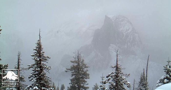
Finally, winter arrives in Yosemite!
(Photo Courtesy of the Yosemite Conservancy -- 11 am, March 1, 2012)
Yes it's getting a good dusting right now.
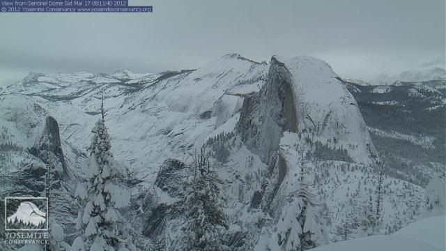
The snow depth at the east kiosk had dropped since the previous storm from around 31" to 25" prior to this weather system. It is now recorded at a depth of just over 40", so quite significant.
Tuolumne Meadows has also seen an increase of 15" in snow depth over the last few days, with a total of 30" now on the ground.
Dave.
Once again the snow pack has been melting away and the reported depth at Tuolumne Meadows is as little as 12" as of today.
Half Dome is almost 'bare back' !!
Snow is forecast daily through the coming week, but is only expected to produce an extra 12" of new settled snow at this point.
Dave.
The last report is now turning into quite a serious weather event where we could see up to 3ft of new snow laid down. This could have an impact on travel conditions at the lower elevations and at the southern end of the Sierras [see below].
Special Weather Statement
SPECIAL WEATHER STATEMENT
NATIONAL WEATHER SERVICE SAN JOAQUIN VALLEY - HANFORD CA
202 PM PDT WED MAR 14 2012
CAZ089>099-151100-
WEST CENTRAL SAN JOAQUIN VALLEY-EAST CENTRAL SAN JOAQUIN VALLEY-
SOUTHWESTERN SAN JOAQUIN VALLEY-SOUTHEASTERN SAN JOAQUIN VALLEY-
MARIPOSA MADERA AND FRESNO COUNTY FOOTHILLS-
TULARE COUNTY FOOTHILLS-KERN COUNTY MOUNTAINS-
SIERRA NEVADA FROM YOSEMITE TO KINGS CANYON-
TULARE COUNTY MOUNTAINS-INDIAN WELLS VALLEY-
SOUTHEASTERN KERN COUNTY DESERT-
202 PM PDT WED MAR 14 2012
...A CHANGE IN THE WEATHER FOR CENTRAL CALIFORNIA...
A LARGE UPPER LOW PRESSURE SYSTEM WILL MOVE INTO THE CENTRAL
CALIFORNIA INTERIOR FRIDAY NIGHT. THIS IS FORECAST TO BE A
STRONG...COLD SYSTEM AND WILL BRING PRECIPITATION AS FAR SOUTH AS
KERN COUNTY. TEMPERATURES BY SUNDAY WILL BE 10 TO 15 DEGREES BELOW
NORMAL AS THE COLD AIRMASS MOVES INTO CENTRAL CALIFORNIA. THE SNOW
LEVEL WILL FALL TO AROUND 2000 FEET BY SUNDAY MORNING AND SNOW
COULD ACCUMULATE IN THE GRAPEVINE AND TEHACHAPI AREAS ON
SUNDAY...ADVERSELY IMPACTING TRAVEL OVER INTERSTATE 5 AND HIGHWAY
58. SNOW COULD ALSO FALL IN THE SOUTHERN SIERRA NEVADA FOOTHILLS.
IN THE HIGHER ELEVATIONS OF THE SOUTHERN SIERRA NEVADA...2 TO 3 FEET
OF SNOWFALL IS POSSIBLE FRIDAY NIGHT AND SATURDAY WITH SEVERAL
INCHES ADDITIONAL SNOWFALL LIKELY ON SATURDAY NIGHT AND SUNDAY.
WINDY CONDITIONS WILL ALSO ACCOMPANY THE INCOMING STORM SYSTEM ON
FRIDAY NIGHT AND SATURDAY...ESPECIALLY THROUGH AND BELOW THE KERN
COUNTY MOUNTAIN PASSES AND OVER THE HIGHER ELEVATIONS OF THE
SOUTHERN SIERRA NEVADA.
THERE WILL BE A SLIGHT CHANCE OF THUNDERSTORMS IN THE SAN JOAQUIN
VALLEY AND ADJACENT FOOTHILLS ON SUNDAY AS A COLD AND UNSTABLE
AIRMASS MOVES OVERHEAD.
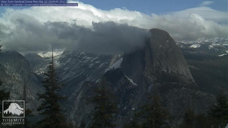
Checked out the Sentinel Cam yesterday and it didn't look a lot different to the image posted above.
Took another look today and ...........................
With more to come !! [That's a little more like it]
The 2011 snow hump is back!
Photo Courtesy of the Yosemite Conservancy
They are expecting up to another 10 inches of new snow to lay on Saturday, but it's still not amounting to much in Tuolumne Meadows. The temps have been mild for the time of the year and the snow fluffy. Looking at the updates page I calculate that there has been over 7 feet of new snow fall over the last 6/7 weeks, yet the overall depth has increased only by 6" to 30" as of March 27. [Theres a reported 70" snow depth near to the east entrance station.]
All that means very little in reality, the weather will do exactly as it pleases in the future, as usual !!
First shot; Friday May 4th @ 11am
Last edited by Southwest Dave; 04-20-2012 at 02:38 PM.
 Posting Permissions