Would this be in the UP of Michigan, per chance?
Mark


Would this be in the UP of Michigan, per chance?
Mark
So this would be in Versailles, KY at Castle Post gotta look at google maps to figure out the road!
How about US-Hwy 60?
Mark
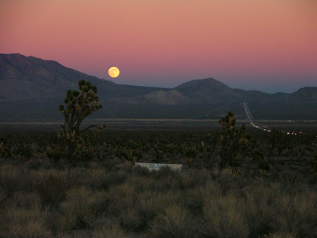
How about this one?
(photo by Mark Sedenquist)
You got it.Originally Posted by Mark Sedenquist

 RoadTrip Guru & Enthusiast
Mark, I'm going to say your pic is of I-15 south of Las Vegas, where it comes out of the mountains at the NV-CA state line.
Nice moonrise, regardless.
Foy
South NV/CA was my guess too...
But Very nice shot... I never seem to have my camera when the moon looks like that :)
love the color of the sky
Yep, that is I-15 making it's way up to Mountain Pass, California. I'm standing at the Halloran Summit off-ramp looking northeast. This is about 95 miles south of Las Vegas.
Excellent work!
Mark

What is this?
Where is it?
Who's that in the picture?
What's he doing?
Why is this guy doing that?
Photo: Don Casey (critical bits of evidence smudged out)
Making the 4th question easier:
Photo: Don Casey
Last edited by CalOldBlue; 09-06-2010 at 02:37 PM. Reason: added blow-up of portrait
RoadTrip Guru & Enthusiast
Well, I missed it by, what, 65 miles or so? I thought it was a view of the northbound side headlights descending the long grade immediately on the CA side of the line. Following your post specifying Mountain Pass/Clark Mountain, I checked a map and saw there's a bend in I-15 near the base of the mountain west of Primm, so mine was clearly erroneous from the get-go.
The location I thought was pictured stuck with me even though I've only passed by there once. As my son and I departed the LV area bound for Port Hueneme, CA in 2007, we were struck by the length and apparent steepness of the grade as we proceeded south down I-15. We agreed it appeared as though I-15 went up a ski jump.
Foy
We're talking about the same mountain range, but the headlights viewed are actually southbound on I-15, driving the stretch between Mountain Pass, CA and the top of the Baker Grade (also known as the Halloran Summit).
Yeah, that section is steep and it's the other side of the pass (the section you've described is north of Mountain Pass) and I think I'll go and get a photo of that sometime -- by contrast the section you've described would appear to be nearly three times as long (as the photo above) and twice as steep. I've seen some really bad roll-overs on that section of the road. The steepness of the pitch is deceptive and unwary or very sleepy drivers can really pick-up speed as they go downhill to the state line at Primm. One time, I watched (from southbound lanes) as a 10-wheeler refrigerated truck (going north-bound) did three complete nose to tail rolls and ended back on it's wheels on the shoulder. I bet that was a very wild ride!The location I thought was pictured stuck with me even though I've only passed by there once. As my son and I departed the LV area bound for Port Hueneme, CA in 2007, we were struck by the length and apparent steepness of the grade as we proceeded south down I-15. We agreed it appeared as though I-15 went up a ski jump.Nah, those two sections of road are only about 14 miles apart!I checked a map and saw there's a bend in I-15 near the base of the mountain west of Primm, so mine was clearly erroneous from the get-go.
Mark
 Posting Permissions