 325 miles - 7 to 9 hours
Historic Sacramento is the gateway to a day's adventure that includes visits to the geographic center of the tomato and olive growing industry and boiling mud pots heated by a very active volcanic mountain. Along the way, you can catch glimpses of golden eagles and a waterfall that oozes more water from its sides than runs over the top. Interstate highways sometimes get derided for their lack of scenery but I-5 between Sacramento and the Oregon state line disproves this stereotype.
Here are some highlights along the route.
Sacramento, California (Starting point).
Sacramento is the state capital of California. The capitol grounds are beautiful and a nice place to wander around. However, this route starts in 'Old Sacramento' on the shores of the Sacramento River. The California Railroad Museum is a couple of blocks to the north, and there are lots of activities and events happening every day in Old Sacramento.
Williams (mile 58)
Sacramento is essentially the midpoint for the 600-mile long central valley, which is highly productive farmland. In the fields to the left and right you'll see nut crops (pistachios, walnuts, and almonds) as well as vast expanses of olive orchards and rice fields. Williams has an impressive arch on the main street welcoming visitors. It's the center of the tomato growing region in California. It's also home to the Sacramento Valley Museum, which is housed in a high school built in 1911. It has one of the best collections of California artifacts from the mid-1800s to the early 1900s. Williams is also home to Granzella's Restaurant, which serves home-made Italian Gelato and great steaks.
Corning (mile 111)
Corning calls itself 'The Olive Capital of the US' and it's always fun to stop here to pick up some of the local olive oils and specialty nuts which are hard to find elsewhere. California is the only U. S. state that produces olives, with about a half dozen different species of olives being grown. It produces about 70 to 80% of all ripe olives sold in the US. In the middle of town is the 'Olive Pit,' which is a bit touristy - they have 'Olive Girls.' The best values in town can be found at the Olive Hut on the south side of town, which carries local olive products. I recommend you try the chipotle pepper-stuffed olives!
Dye Creek Canyon Preserve (mile 130)
Dye Creek Canyon Preserve is managed by the Nature Conservancy. It's not open all the time to the general public, so you'll need to call ahead. It's an extraordinary place, and one can often see golden eagles and various types of woodpeckers. It's also a sure bet for wildflowers in the spring. In the preserve is a cave that is believed to have been used by Ishi, the last survivor of the Yahi native American nation.
Lassen Volcanic National Park (mile 193)
Climbing east from the flat plain of the Sacramento Valley, you'll soon see snow on Mt. Lassen, even during the hottest months of the year. You'll drive across miles of old lava flows on the approach to the park. Lassen Volcanic National Park was home to large, explosive volcanic eruptions in 1914-1915. These explosive eruptions were larger in scale than Mount St. Helens and continued over a period of about a year, through 1915. Fortunately, the area was sparsely populated, so almost no lives were lost. Today, 90 years later, the remains of the eruption are almost completely covered by green forests and sparkling lakes. But even today, there are sometimes jarring reminders of the volcanic past. On the main road through the park, there are two areas of boiling mud pots and steaming ponds heated by the hot earth below. About a mile or so off the road is a larger valley with bubbling hot ponds, mud pots, and a large stretch of sulfur and mineral streaked hillsides called 'Bumpass Hell.'
Burney Falls (mile 240)
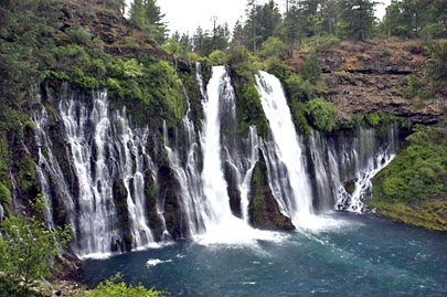
Burney Falls, which are in the McArthur-Burney Falls Memorial State Park, are an interesting volcanic-based attraction on today's route. The falls are large, falling about 130 feet, and are about 50 yards wide. What's different about them is that only about half of the water actually goes over the falls - the rest goes through the rock face of the falls, spurting out and falling in a series of smaller falls along the entire rock face the water tumbles over. This is due to the porous volcanic lava that underlies the water's course, which lets the water down through the rock, instead of tumbling over the top. It's quite interesting and unique. Teddy Roosevelt called these falls 'the eighth wonder of the world' when he viewed them a hundred years ago. The pool at the base of the falls and the river below are also known as good fishing grounds, and we saw several persons fishing in the river below the falls. I even talked to a young man who attempted to snorkel in the large pool at the base of the falls. He reported seeing very large fish in the pool, but quickly gave up the attempt to swim due to the rather cold water, the turbulence from the thundering falls, and, as he reported: 'getting dive bombed by these big fish!'
Mt. Shasta (mile 325)
Mt. Shasta is a picturesque town at the base of the 14,162-foot Mount Shasta. Mt. Shasta is the second highest volcano in the United States and makes a good gateway town for exploring the region.

Burney Falls is one of the most intriguing
waterfalls in the country
Photo courtesy of © Jon R. Vermilye
Click here for more photos of waterfalls and natural wonders taken by Jon R. Vermilye
Click here for more photos of waterfalls and natural wonders taken by Jon R. Vermilye


Message from RoadTrip America