
Getting Out There: |
Directory of all "Getting Out There" Articles> |
Interstate 70 through Eastern Utah by Mark Sedenquist
(Continued from Page 1)
|
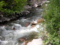
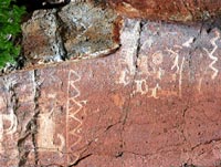
The next exit (mile marker 8) provides a very nice two-lane drive along Clear Creek on SR-4 (it parallels I-70). The creek bisects the Kimberly Mine district that at one time employed 2,000 gold miners, and it's easy to see some of the mine tailings as you head down to the Fremont Indian State Park. This park can also be accessed from I-70 at mile marker 17. I must have driven by this place ten times, each time saying, "Next time I'm going to stop and see what's there." Don't follow my example -- stop the first time! In most places in the west, it takes a bit of a journey off major routes to see pictographs and petroglyphs left behind by native cultures. Not here! The traffic lanes for the east-bound side of I-70 were constructed directly through a historic Fremont Indian village, and the canyon walls surrounding the highway are covered with all kinds of rock art. No one really knows what these drawings signify, but the local Paiute nation considers Clear Creek Canyon to be sacred. There is an excellent visitor's center and short (.3-mile) loop walking trail that winds past a number of examples of this art. There are 14 separate trails within the park, and once you know what to look for, you can even spot petroglyphs from the highway!
Next: Spectacular roadside viewpoints!>
Mark Sedenquist
April 16, 2006
More "Getting Out There" Articles>
|
|
Privacy Policy |
Copyright 1996 - 2025, RoadTrip America® - All Rights Reserved |
Contact RTA |