
Getting
Out There: |
Directory of all "Getting Out There" Articles> |
1,200 Miles in Four Days by Mark Helmlinger
|
Death Valley recently had flash floods and record wild flowers, but now there are only scattered husks left. We stopped at the Furnace Creek Ranch for ice cream and to gander the impromptu bulletin board with pictures of the flood damage. The nearby Borax Museum is a must-see for rock hounds, but we found out it was closed for lunch.
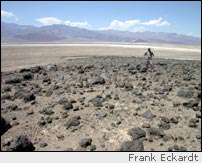
Our next point of interest, after ogling the posh accommodations to be had at the Furnace Creek Inn , was the prehistoric footpath along the fault scarps, and the scarps themselves, along the eastern side of CSR-178 to Badwater. We stooped to pay homage at Mars Hill, where NASA's Mars rovers have been tested. It's across from the end of Artists' Drive, overlooking the valley. The rocks and volcanic sand look very Mars-like -- especially after you Photoshop a bit of pink tinge into the picture!
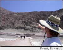
We then hit the unusual salt formations of Devil's Golf Course and checked out the salt water springs at Badwater. There have been improvements made to the parking area and ramps at Badwater, making the place more visitor-friendly. The "SEA LEVEL" sign 282 feet up on the scarp has been redone as well.
We took the road south to Shoshone out of the park. Gravel had been washed onto it by monsoon-fed thunderstorms the day before. It was a harbinger of things to come. We drove through Pahrump and spent the night in Las Vegas. Even if you're not a gambler, Vegas is an interesting place to visit at least once, and all the neon is quite an anachronistic shock after bumping around the hinterlands. The next morning we tried to find gypsum crystals at a remote playa. We made a poor entry point choice, got a flat tire, slid around in unexpected mud, nearly got zapped by lightning, and got chased out by flash foods, but that's a story for another day.
Dodging a second thunderstorm, we joined up to the Excelsior Mine Road and then across Interstate 15 to the Cima volcanic fields. I must say, there is nothing like rain in the desert -- at a distance. After hiking around the basalts of various ages with satellite images in radar and infrared, we decided to visit the biggest Aeolian features around: Kelso Dunes.
After all that, it was a fast drive west on I-40 and back to I-15, and then home to Los Angeles. What a loop -- 1,200 miles in four days! On trips like this, it's difficult not to think big thoughts. A multi-million-year story of change has been writ large across the landscape. Even if you don't cover 1,200 miles in four days, get out there and see it for yourself!
Mark Helmlinger
August 7, 2005
More "Getting Out There" Articles
|
|
Privacy Policy |
Copyright 1996 - 2025, RoadTrip America® - All Rights Reserved |
Contact RTA |