
Getting
Out There: |
Directory of all "Getting Out There" Articles> |
1,200 Miles in Four Days by Mark Helmlinger
|
We then split off Interstate 5 onto California State Route-99 north and went on through Bakersfield. We left CSR-99 for CSR-65 north past Oildale. Much of the Central Valley experience is captured in this photo essay by Stephen Johnson. I always wonder what's planted in the endless fields on the side of the road. I also know that a huge proportion of the water moved around in the aqueducts is for farming, and that valley agriculture is a huge economic engine for California, and helps make it the world's fifth largest economy. The San Joaquin valley is reputed to have the dubious honor of having the worst air quality in the country. According to one study, the local cow population gets much of the blame for this. As a result of the metabolic processes (known as "enteric fermentation") when cattle are fed, they burp large amounts of methane. Methane contributes to the brown color of smog.
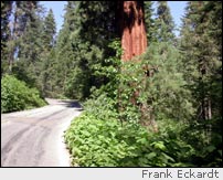
We continued north through a cute little town called Exeter to California State Route 198 into Sequoia & Kings Canyon National Parks. We used our Golden Eagle Passport for entry. (This annual pass is good for admission to many federal sites and Bureau of Land Management lands as well as national parks.) Through the park, we stayed on CSR-198, and did not go to Mineral King or to the famous Cedar Grove in Kings Canyon National Park. Time constraints meant we had to keep to our planned schedule. We followed CSR-198 around through the park (a beautiful drive in itself) and then followed CSR-180 down to the flatlands and into Fresno.
We then continued north on California State Route 41 into Yosemite National Park, crossing the famed Gold Rush Trail at Oakhurst. We were told at the entry kiosk that there were absolutely no campsites available. It was late afternoon, and we were unsure of what to do, but I figured we'd work it out when the time came. We motored on past the park rangers, who were shaking their heads. That afternoon, we took in the valley floor, went swimming in the Merced River (chilly, but no crowds) under El Capitan, and took some great photographs.
We left the valley floor after dark, headed
up CSR-41 to Crane flats and found a lonely granite-edged
pullout along the way to spend the night -- figuring a park
ranger might or might not ask us to leave. When you think
about it, pullouts are meant for travelers to take in the
view, fiddle with their vehicles and such, or take a much-needed
rest. So, we rested in a quiet and self-contained way all
night, were not bothered at all, and we had a fantastic view
of the lower valley the next dawn. It was between two roaring
boulder falls, tributaries to Crane Creek. The sound of tons
of water crashing over house-sized boulders drowned out the
occasional passing car. Yosemite bliss on the quick and cheap
-- no reservations necessary!
Next: Tioga Pass, Bodie Ghost Town, & Mono Lake>
Mark Helmlinger
August 7, 2005
More "Getting Out There Articles>
|
|
Privacy Policy |
Copyright 1996 - 2025, RoadTrip America® - All Rights Reserved |
Contact RTA |