
Getting
Out There: |
Directory of all "Getting Out There" Articles> |
1,200 Miles in Four Days by Mark Helmlinger
|
We then left US-395 for CSR-136 to CSR-190 past Owens lake. Owens Lake was a broad lake of great enough depth and extent that silver was barged across it from the Cerro Gordo mines. The lake dried up after Los Angeles Department of Water and Power, (LADWP), diverted its waters and it became the youngest playa (dry lake) on Earth. The lake muds, made in part of light ash from the volcanic formations upstream, quickly dried and blew away, becoming the most significant point source for dust in the continental United States. After a significant dust event, one percent of the dust found on the East Coast could be traced to Owens Lake! LADWP has been sued by the Environmental Protection Agency to remediate the problem, and several methods have been implemented. What we saw looked like an effort to quarry dolomite from a nearby formation and spread it over the lakebed, perhaps hoping to cement the surface. Other parts of the lakebed seem to be growing more saltgrass, and others are being flooded.
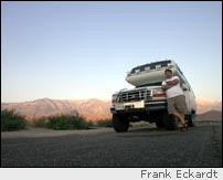
It's beautiful drive to Father Crowley Point on CSR-190. Do drive all the way out to the lookout. From there the dunes of Panamint Valley can be seen. If you are lucky, you might see some military airpower maneuvers during the week.
We tanked up on water at Panamint Springs before entering Death Valley. Then we drove over Towne Pass to Stovepipe Wells. The pass is very steep both ways and not for the faint of heart. Only well-maintained vehicles should attempt the grade in summer heat. Rolling down Towne Pass with the air conditioner going full blast, you're cool and comfy until you step outside at Stovepipe Wells. Do so, and you'll know what the expression "stepping out into an oven" means. This could have something to do with why the campground at Stovepipe was completely empty.
We drove past the arrow weeds (used by
Native Americans to make arrows) of Devil's Cornfield, then
stopped at the Harmony Borax Works before winding through
Mustard Canyon. Then we took in the Furnace
Creek Visitors Center. The relief map in the middle of
the museum is a work of art, and the displays cover a wide
range of the park's history and heritage.
Next: Furnace Creek, Badwater, Las Vegas, and the Kelso Dunes>
Mark Helmlinger
August 7, 2005
More "Getting Out There Articles>
|
|
Privacy Policy |
Copyright 1996 - 2025, RoadTrip America® - All Rights Reserved |
Contact RTA |