| Hole-in-the-Wall & the Kelso Dunes | ||||||||||||||||
MOJAVE
NATIONAL PRESERVE, CALIFORNIA— If you ask someone what lies halfway between Los Angeles and Las Vegas, you're likely to get a blank look and a one-word answer: nothing. It's that widely held belief that has kept the Mojave National Preserve such a fabulously untrampled place to explore. Those who do venture into the 1.5 million acres between Interstate 40 and Interstate 15 to find out why the area was officially made part of the National Park System in 1994 discover a fascinating world of historic railroads, unusual rock formations, and sand dunes tall enough to impress Lawrence of Arabia.
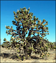
Nearly 300 species of animals live here, too, including desert bighorn sheep, desert tortoise, mule deer, and coyotes. The Preserve is also home to a variety of birds, including those well known to western roadtrippers: roadrunner, eagle, and quail. Although the word "desert" does not connote lush vegetation, an incredible number of plants can be found here too, including creosote bushes, Joshua trees, sage brush, junipers, California coastal oaks, cottonwoods, and pinon pines. In the winter and spring, wildflowers abound. With its extremes in altitude, vegetation, weather, and topography, the Mojave Desert is a mesmerizing study in contrasts, and—as long as you come properly prepared—a fascinating area to explore by car. After leaving Interstate 15 at Nipton Road, we entered the Preserve on Ivanpah Road and skirted the edge of the Cima Dome forest, one of the largest and densest groves of Joshua trees in the world. Individual trees are unusually large, too, and photo opportunities abound. After leaving the Joshua tree forest, the road follows the tracks of the historic Union Pacific Railroad. We saw a freight train with eight engines-all of them running-pulling a long string of cargo cars up the steep Cima grade. When we reached the end of train, we found out that eight locomotives weren't enough. Two "pushers" were laboring away, too.
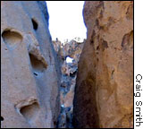
Not much is left of the town of Cima—the word means "summit" in Spanish—but there is a U.S. post office in operation as well as a small café. Rolling on toward Kelso, we decided to take a short side trip to Hole-in-the-Wall, an aptly named rock formation created by a violent series of volcanic eruptions nearly nineteen million years ago. A prodigious quantity of rhyolite lava was squeezed up from underground magma chambers to form bulbous plugs and domes on the edge of a huge caldera that lies under this part of the Preserve. (For more detailed information about the geology of Hole-in-the-Wall, click here.)
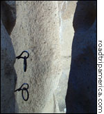
We parked in a lot near the campground and walked the short distance to the mouth of the narrow gorge that gives Hole-in-the-Wall its name. It's possible to see quite a few of the unusual rock formations from the viewing platform at the top of the canyon, but for the more adventurous, heavy metal rings anchored in the rock make it possible to climb down into the canyon and walk along its floor. After we climbed back out of Hole-in-the-Wall and enjoyed a picnic lunch, we got back on the road to Kelso. Kelso is home to one of the Preserve's most-photographed landmarks, the grand old Spanish-style Western Union railroad depot built in 1924. The Park Service is in the process of turning it into a visitors' center set to open in fall 2003. From there, it was only a short drive to the Kelso Dunes trailhead.
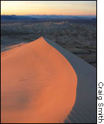
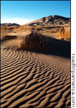
The
dunes rose steeply in what looked like the near distance. We parked,
donned our hats, strapped on our fanny packs and water bottles,
and started walking. Within about 100 yards, gravelly dirt gave
way to extremely fine sand, and our progress was slow. Fortunately,
this gave us the opportunity to notice a few subtleties, like the
dainty tracks of a black beetle, a little bird, and a lizard. Even
the grass left artistic tracings in the sand as the wind blew it.
(For the interesting detective story of how the Kelso Dunes were
formed,
click here.)
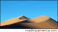
The view of the desert floor and surrounding mountains got better and better as we slowly gained altitude, and we were glad we had chosen to ascend the dune in late afternoon. The raking sunlight cast fantastic shadows and turned the slopes different colors every few minutes. At last we reached the crest of the tallest dune, 700 feet above the desert floor. It had taken us about ninety minutes. Happily, it wouldn't take nearly as long to get back down.
In addition to wonderful vistas and fascinating wildlife, the Kelso Dunes have another memorable feature. Something about the shape of the sand grains creates a booming sound whenever there's an avalanche. Better yet, it's easy and safe to start one. We stood at the top of the tallest cornice. The face below us was steeper than most ski runs. One at a time, we spread our arms wide and jumped off. As we plunged down the dune, knee-deep in fine golden sand, the deep harmonics emerged. Weird! Wonderful! Like flying! We wished the dune were twice as tall, because it was all over way too soon. All evidence that we were even there was quickly gone, too. No sooner were we at the bottom of the slope than the wind and shifting sand had already erased most of our footsteps.
We poured the sand out of our shoes and started back. Even though we had "flown" down the slope, it still took most of an hour to reach the trailhead. The sun had set, and even though a nearly full moon cast enough light to throw shadows, we were glad we'd carried flashlights. —Mark
Sedenquist
|