Page 2 of 4 FirstFirst 1234 LastLast
Results 11 to 20 of 39
  1. #11
    Join Date
    Jul 2007
    Location
    South of England.
    Posts
    12,167

    Default Big task ahead.

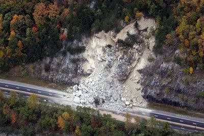
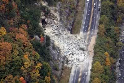
    It looks like that is going to take more than a dust pan and brush to clear up, and to make the area safe again is going to take some doing.

    Here are a couple of shots taken of the scene.


    This one seems to reveal the starting point which has left a large void.


    Those boulders are slightly on the large side !!


    Are their small towns, local services nearby ? It could have a big impact on those who rely on the Interstate to keep their business running.

  2. #12

    Default Local effects

    Dave,

    The rockslide itself is in the midst of an isolated segment of I-40 within the Pigeon River Gorge, itself within the western 1/4 or so of I-40's traverse of the southern Blue Ridge/northern Smokies. The problem is there is no other Interstate-quality alternative route other than the long detour up to I-26, thence back to Asheville. For I-40 travelers originating or bound for positions much farther east in NC or nearby VA, there is little reason to use the posted detour, as other routes from Knoxville, TN (along I-40) to central and eastern NC and all of VA are more direct than the detour. In short, businesses from roughly Statesville and Winston-Salem, NC, all the way to Morrisville, TN, are expecting to see a sharp decline in sales. The drop for those between Asheville, NC and Newport, TN will see only local traffic during the entire repair period.

    Foy

  3. #13
    Join Date
    Oct 2008
    Location
    Joplin MO
    Posts
    10,318

    Default

    There's essentially nothing at all up there in the immediate area, but I can see it having an effect on travel-related businesses between I-81 and Asheville - because of a huge decrease in traffic between them. I haven't been up there in about 10 years or so, but I used to run it quite frequently when I lived in Chicago and my mom lived in NC. It's pretty desolate.

    To my knowledge, there's no small local roads that will get you around it, so local drivers even have a substantial detour to get between TN and NC. There may be some forest service roads, but I doubt that they are passable in a normal car.

    EDIT: I was still composing when Foy just posted - there's still going to be some through traffic between Asheville and Lake Junaluska - US-23 is a fairly well traveled route. That still leaves about 45 miles that will essentially be a ghost town. Most of that stretch is in the Pisgah National Forest.

  4. #14
    Join Date
    Jul 2007
    Location
    South of England.
    Posts
    12,167

    Default Slow going.

    I have just been looking for updates, and it seems they still have to blast away at the slope to make the area a safe working environment before further progress can happen. It's a massive undertaking and they are looking at February and $10 million dollars to get it open !

    An update with blast footage on the right of the page.

    And the Latest news and picture update that shows some of the machinery on site, and some amazing facts about the size of the task immediately to hand.

    Better footage of the blasting here
    Last edited by Southwest Dave; 11-15-2009 at 10:34 AM. Reason: Added another link.

  5. #15
    Join Date
    Nov 2005
    Location
    The Great Midwest, Illinois to be precise
    Posts
    519

    Default Still Closed

    It put a crimp into my travel plans over Thanksgiving as I was planning on driving it to visit my nephew and family in Tennessee on the way home from North Carolina.

    My nephew said the detour took about an extra 45 minutes.

  6. #16
    Join Date
    Oct 2008
    Location
    Joplin MO
    Posts
    10,318

    Default

    The latest construction update in Microsoft Streets & Trips says it's closed till April 30, for what that's worth.

  7. #17
    Join Date
    May 2003
    Location
    Green County, Wisconsin
    Posts
    13,830

    Default news reports

    Pretty much all of the news releases and media reports from local TV and newspapers over the last week or two say they are aiming to have the road reopened in March. They are working around the clock on the project and It sounds like the weather will be the biggest factor in determining if they meet the March goal.

    In the meantime, I found it rather interesting that Google maps has actually deleted that stretch of road off of their online maps.

  8. #18

    Default And there's more..............

    .......another rockslide has covered I-40 at a point around 4 miles east of the Milepost 2.5 big slide. The new one impacted an already-closed section, is "limited" to some 50 dumptruck loads of rock and soil, and is not expected to delay the re-opening in any way.

    Foy

  9. #19
    Join Date
    Jul 2007
    Location
    South of England.
    Posts
    12,167

    Default Not good.

    Quote Originally Posted by Foy View Post
    .......another rockslide has covered I-40 at a point around 4 miles east of the Milepost 2.5 big slide. The new one impacted an already-closed section, is "limited" to some 50 dumptruck loads of rock and soil, and is not expected to delay the re-opening in any way.

    Foy
    That must raise some eyebrows though and surely cause new concerns on the stability all along that stretch of I40.

  10. #20

    Default Absolutely, it does......

    .........and that stretch of I-40 has been unstable for decades, unfortunately.

    Foy

Similar Threads

  1. Driving I-40 Smoky Mountains
    By christy2823 in forum Fall & Winter RoadTrips
    Replies: 8
    Last Post: 10-10-2009, 11:47 AM
  2. Rocky Mountain Motorcyle Tour 2009
    By WinginIt in forum RoadTrip Field Reports
    Replies: 1
    Last Post: 10-07-2009, 08:31 AM
  3. Great Smoky Mountains Adventure
    By JF2CBR in forum Spring RoadTrips
    Replies: 1
    Last Post: 02-24-2007, 06:01 PM

Posting Permissions

  • You may not post new threads
  • You may not post replies
  • You may not post attachments
  • You may not edit your posts
  •