Page 3 of 15 FirstFirst 123456789101112131415 LastLast
Results 21 to 30 of 146
  1. #21
    Join Date
    Jan 1998
    Location
    Las Vegas, Nevada
    Posts
    13,002

    Default Bridge + Bridge + Train Track

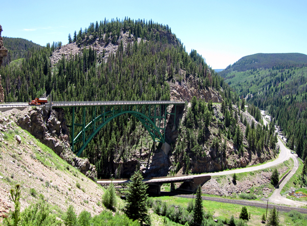
    I love the engineering depicted in this photo...

    (Photo by Dan Sedenquist)
    It's not on the west coast, but it's a bit further east than some of my recent images. So what's the name of this bridge or the location? (In fact, it's near Kestrel's home town...)

  2. #22
    Join Date
    May 2009
    Location
    SF Bay Area
    Posts
    812

    Default Randumb guess

    Looks like somewhere along I70 near Vail?

  3. #23
    Join Date
    Jan 1998
    Location
    Las Vegas, Nevada
    Posts
    13,002

    Default very, very close

    That's not I-70, but it is very near Vail....Care to make another stab at the location?

    Mark

  4. #24

    Default Ohhh, Ohhh, I know

    That's the US-24 bridge over Game Creek near Minturn, CO, enroute to Camp Hale, Tennessee Pass and Leadville, CO as one drives south from I-70 between Vail and Beaver Creek. Ski Cooper ski resort is at Tennessee Pass.

    Hope that's close enough for me to earn a "two-fer" when combined with Harpers Ferry. As is said here in North Carolina: "Even a blind hog finds an acorn once in a while". Actually, I drove my son Cooper over that bridge enroute from Glenwood Springs back to Denver on a father/son fly-n-drive in January 2000. We had time to kill and wanted to see Ski Cooper.

    Foy

  5. #25
    Join Date
    Jan 1998
    Location
    Las Vegas, Nevada
    Posts
    13,002

    Default I think we are looking at the same bridge!

    Foy,

    Yeah, that's darn close -- I don't have a good enough map to confirm whether or not this is the same bridge... but Dan identified the lower road as being the road that goes over Shrine pass just outside of Gilman. And, of course, that it is US Highway 24. Did you catch the Colorado Dept of Highways truck in the photo?

    Excellent work for this two-fer!

    Mark
    Last edited by Mark Sedenquist; 08-04-2009 at 06:59 PM.

  6. #26
    Join Date
    May 2009
    Location
    SF Bay Area
    Posts
    812

    Default That would be....

    Red Cliff Bridge; US24 and the Eagle River.

    I THOUGHT it looked like Western Slope.

  7. #27
    Join Date
    Jan 1998
    Location
    Las Vegas, Nevada
    Posts
    13,002

    Default I think it is the Game Creek Bridge

    But it could be the Red Creek Bridge -- I need to reach Dan and see how his memory is. I've looked at the topo maps and neither of these two bridges look like a perfect match... (weirdly).

    Corrected and confirmed -- see below!

    Mark
    Last edited by Mark Sedenquist; 08-04-2009 at 04:53 PM.

  8. #28

    Default Ready, Shoot, Aim........

    Nah, I think I missed it. The bridge I'm recalling is the Red Cliff bridge, I'm pretty sure. As we returned to I-70 from Ski Cooper, I pondered my CO DeLorme and wondered if the road from Red Cliff was open to Vail Pass. I should have known better, and sure enough the road was closed just on the far side of Red Cliff town limits. I correctly recalled signage on I-70 directing to US 24 (not CO 24) and Minturn, and stole a glance at Mapquest to ID the stream crossing there. Had I zoomed out and seen Red Cliff, I'd have followed the creek east of there to Vail Pass. I didn't do that, and I'm pretty sure I got it wrong.

    One of these days, have a look at the historical significance of Camp Hale. Many denizens of the Western US owe a lot to the individuals who served there, not only for their military actions, but also for what they collectively accomplished after the survivors returned from overseas.

    Oh well, I'm batting .500 today, anyway.

    Foy

  9. #29
    Join Date
    Jan 1998
    Location
    Las Vegas, Nevada
    Posts
    13,002

    Default The Photographer is on the case

    Dan just wrote and confirmed that Don was correct! It's the bridge that crosses the Eagle River just downstream from the town of Red Cliff.

    Damn, you guys are good at this!

    Here's a satellite image of this exact bridge location....

  10. #30

    Default Wtg!

    Great call, Don.

    Foy

Similar Threads

  1. "Where in North America?" --- Section IV
    By Mark Sedenquist in forum RoadTrip Field Reports
    Replies: 145
    Last Post: 08-02-2009, 02:24 PM
  2. "Where in North America?" --- Section III
    By Mark Sedenquist in forum RoadTrip Field Reports
    Replies: 278
    Last Post: 07-07-2009, 05:00 PM
  3. "Where in North America?" -- Section II
    By Kestrel in forum RoadTrip Field Reports
    Replies: 279
    Last Post: 06-12-2009, 03:00 PM
  4. "Where in North America?" -- Section I
    By Quebec Gen in forum RoadTrip Field Reports
    Replies: 325
    Last Post: 04-29-2009, 02:34 PM
  5. North America
    By jbricke1 in forum Planning Summer RoadTrips
    Replies: 1
    Last Post: 06-03-2007, 10:58 PM

Tags for this Thread

Posting Permissions

  • You may not post new threads
  • You may not post replies
  • You may not post attachments
  • You may not edit your posts
  •