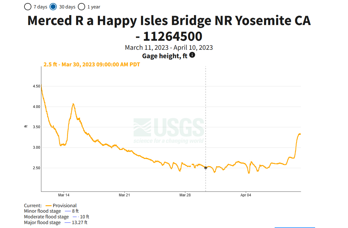
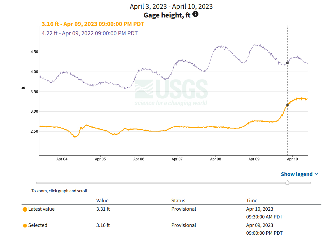
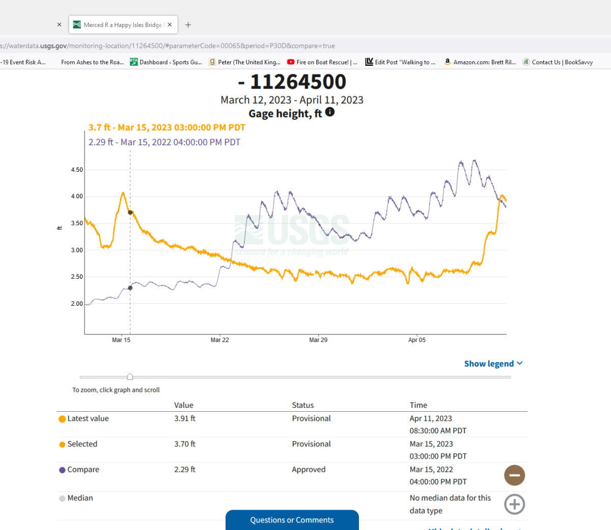
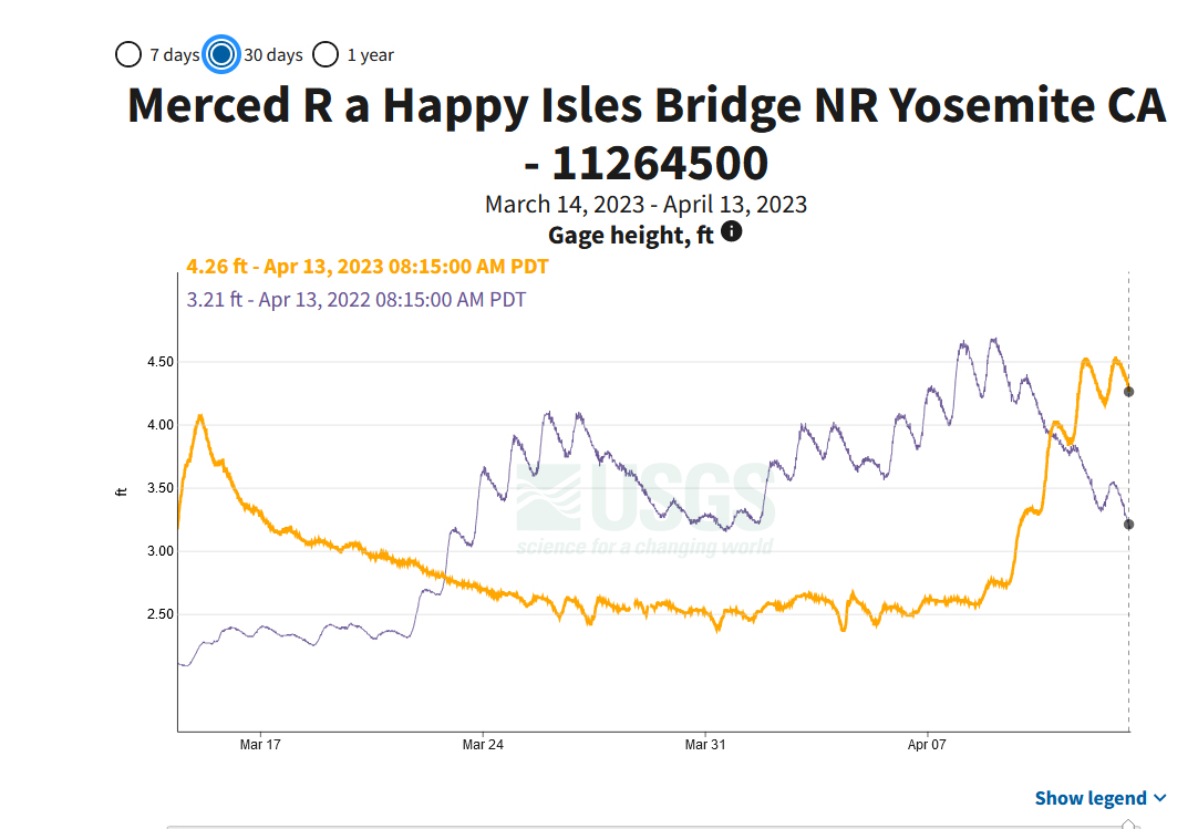
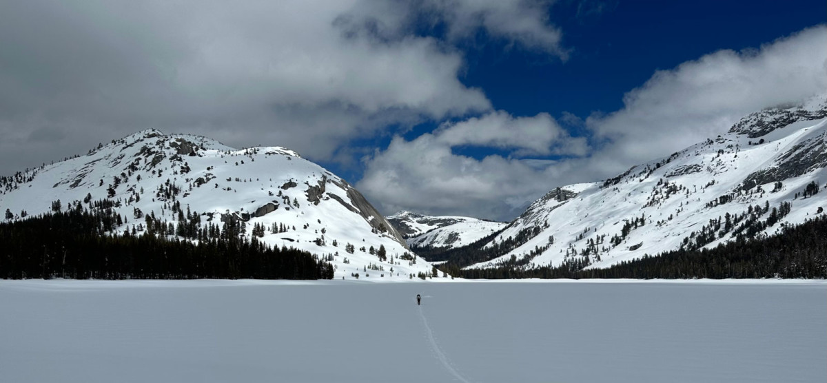
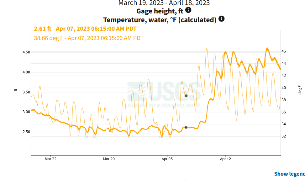
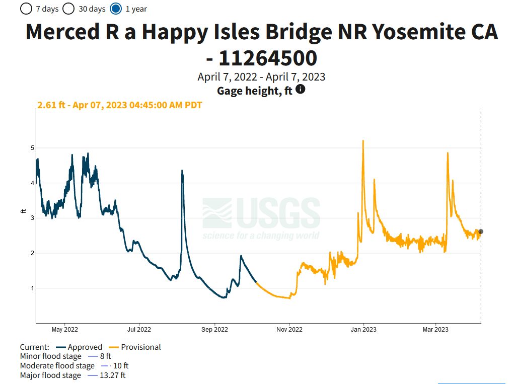
Before May 1st
Between May 1st and 7th
Between May 8th and 15th
Between May 16th and 23rd
Between May 24th and 31st
Between 1st June and 8th
Between June 9th and 16th
Between June 17th and 24th
Between June 25th and July 1st
After July 1st
First is my friend's cabin which is really a 2-story, 4 bedroom house. His family had it built 48 years ago. Kirkwood is location a few miles W of the Sierra Crest where storms that usually come from the SW drop a lot of snow. 705"/approaching 18 meter so far this year. To get from parking area (no garage) you have to climb step cut into snowbank that is at least 20' tall.
6550CabinSteps.jpg
This is one of his neighbors houses. If you look closely (and it loads with enough detail), there is smoke rising from the chimney.
6552Neighbor2.jpg
This is view of parking and the wall of dirty snow thrown up by snowblowers taken from the base of one of the main ski lifts.
0001KWSnowbank.jpg
California Highway 88 W of Kirkwood has been closed often this winter as it crosses an avalanche area called the Carson Spur. One week it was only open for about 24 hrs between storms. If Carson Spur is closed, my route home is about 50 miles longer and includes busier US-50. East of Kirkwood is 8573' (over 2600 m) Carson Pass, open more often as most of the employees who don't live at Kirkwood come over it and it's easier/safer to re-open. There are a few guardrails on the right going down the E side of pass damaged by avalanches that came down from peaks to the left. Some of the walls of snow overhang the highway and could fall onto the road as it warms this Spring.
6561On88.jpg
Thanks for sharing, great photos ! According to the Tuolumne meadows winter Rangers it has been a record year for snowfall up there. Records began around 1930 and the previous record has stayed in tact since 1983, recording an average snow depth of 168.84 inches and 66.98 inches of water content compared to this years figures of 177.3 inches of snow depth and water content of 79.68 inches. With temperatures set to reach up to 55F over the next few days we could see the Merced river flow chart on the increase.
Dave
So, been looking at last year's flows. It looks like the heaviest flow was in the end of May when it reached 5 feet at the gauge.
March 14th to April 13th (2022 and 2023)
--> So I am guessing that it will reach 6.5 feet by the end of May and maybe not peak until June 15th.
As Spring temperatures start to rise the thaw begins and those flow charts are likely to rise. The April snow survey showed the snowpack to be around 244% of average in the Merced and Tuolumne area. They estimate this to be equal to 139 billion gallons of water in the form of snow in the watershed that feeds Yosemite Valley. I have no idea what that actually looks like, but it sounds a heck of a lot !!
So what does this mean for visitors to Yosemite ? According to the NPS.
**Tioga pass, Glacier point and Mariposa grove will open later than usual, that could mean July!?
**River activities like swimming, Kayaking and picnicking by the river are not likely to happen before July, even if the park is open.
**There may be some periods between late April and early July when Yosemite Valley is inaccessible due to flooding.
** The waterfalls will be spectacular, just try and be as flexible as possible when planning a visit.
A spectacular view across Tenaya lake captured on April 1st 2023.
Dave
I still don't think I would be walking across the lake!