
I didn't know there was an app for elevation! Just went to the App store and got one. Thanks!
Donna

I didn't know there was an app for elevation! Just went to the App store and got one. Thanks!
Donna
 RoadTrip Contributer
Sunday, March 22, 2015
Start: MidHills campground (NPS), Mohave National Preserve
Finish: Furnace Creek Campground (NPS), Death Valley National Park
Click here for this RTA Library Map
Extremely quiet night and morning in camp. Definitely cooler at the higher elevation, but not too bad. Left camp and drove out through the eastern section of the park. We had planned to hike the loop trail at Rock Springs along the Cedar Canyon Rd, but never saw the sign off the road. Turned north on Ivanpah Rd, which ran along an historic railroad bed from the late 1800s. We followed the grade on both sides of the road. The view of the New York mountains to the northwest was scenic.
Instead of crossing I-15 and continuing north we had to drive I-15 into Baker. We stopped to top off the gas tank and had lunch at a tasty taqueria on the corner of Business 15 and CA 127. We continued north on CA 127 to Shoshone. We drove through Dublin Gulch, an historic mining cemetery and living area for the miners.
Dublin Gulch - Home, Sweet Home

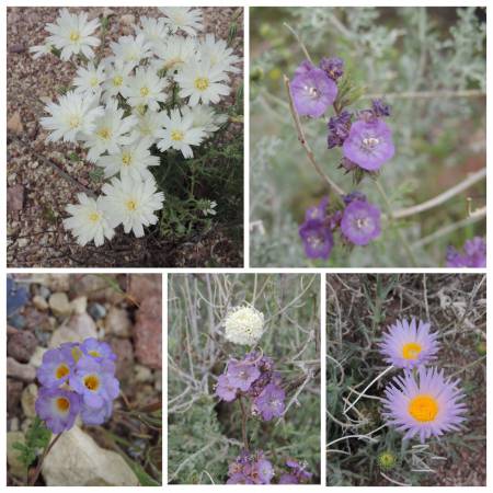
Just north of Shoshone we turned west on CA 178, the southern route into Death Valley National Park. It had been many years since we had taken this route, and today was the perfect day for this route. Flowers Galore! The slopes up to Salisbury Pass were resplendent with the Spring flowers. Photos could not do justice, but I prevailed. My husband commented that I was like a kid in a candy shop.
Death Valley Flowers


We continued down into the valley, once below 1200 feet the flowers disappeared, but the light, as always, was beautiful on the mountains.
Death Valley - East side

Luckily we had made campground reservations at Furnace Creek, even though it was Sunday evening the Full sign was posted as we pulled in. The campground is -196 ft below sea level, and definitely warmer than we had experienced all week, lower 90s. It was overcast with a light breeze which made it very nice.
Passport Stamp
Death Valley National Park - Furnace Creek, CA
Wildlife Sightings
Common Raven
Phainopepla
Great-tailed Grackle
Oak Titmouse
Mourning Dove
Rock Pigeon
Turkey Vulture
Last edited by Tom_H007; 03-06-2019 at 05:19 AM. Reason: Added map

Seeing a Desert Five-Spot in bloom is always a treat!
Thanks for the photos.
Mark
RoadTrip Contributer
Monday, March 23, 2015
Start & Finish: Furnace Creek, CA
Click here for this RTA Library Map
Lazy morning in camp until we ran out of shade. Left Furnace Creek area and traveled to Death Valley Junction, then to Ash Meadows National Wildlife Refuge. This is an area we have wanted to visit because of the sub-unit of Death Valley NP, Devil's Hole. We learned they had just opened their visitor center one month ago. Great day trip from Death Valley. Our first stop was at the Point of Rocks Boardwalk. Besides seeing the Ash Meadow Amargosa Pupfish ( the name is longer than the fish) in the beautiful aquamarine water we heard an agitated rattlesnake, under the boardwalk. A couple before us saw the snake and described it a fat and large, we waited around for quite a while, but all we got was a rattle directly under the boardwalk.
Ash Meadows NWR - Point of Rocks boardwalk & Pupfish springs


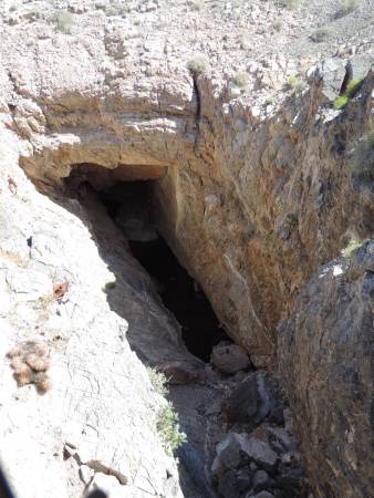
Further down the road, in the refuge, we walked out to the Devil's Hole. You can look down into the cave, but fencing protects these very endangered fish. The water cave is at least 500 ft deep, no one has reached the bottom.
Devil's Hole
Further down the road is the brand new visitor center for the refuge. While there we watched the film and learned about the extensive restoration work that has been done since the 1980s.
Ash Meadows National Wildlife Refuge visitor center

From there we continued north to US 95, then to Beatty, NV. After a drive up into the ghost town of Rhyolite we continued back into Death Valley NP. The best flowers were the ones we saw coming across Salisbury Pass on Sunday.
Rhyolite, NV

We enjoyed a beer and appetizer in the saloon before fixing dinner at camp. The high was 93 at Furnace Creek, much more comfortable up at Ash Meadows which is at 3000 ft. Elevation.
Bonus stamps
Ash Meadows National Wildlife Refuge ( Blue Goose stamp)
-Ash Meadow Sunray, Threatened species
-Ash Meadows Naucorid, Threatened Species
Wildlife Sightings
Bat
Desert Iguana
Greater Roadrunner
Mourning Dove
Rock Pigeon
House Sparrow
Common Raven
Turkey Vulture
Last edited by Tom_H007; 03-07-2019 at 02:46 PM. Reason: Added map
RoadTrip Contributer
Tuesday, March 24, 2015
Start: Furnace Creek, CA
Finish: Independence Creek Campground (Inyo Co.), Independence, CA
Click here for this RTA Library Map
First stop of the day was at Salt Creek Interpretative Trail, north of Furnace Creek. We walked the half-mile trail enjoying the flowing water with lots of active pupfish.
Salt Creek Interpretative Trail

We continued onto Stovepipe Wells for showers. For $4 per person you receive a fresh towel and access to the pool area, for swimming and/or showers. The shower stalls have dispensers for shower gel, shampoo and conditioner. Stovepipe Wells is much more laid back than Furnace Creek, where you can also get showers and use the pool. A few years ago is was $5 per person.
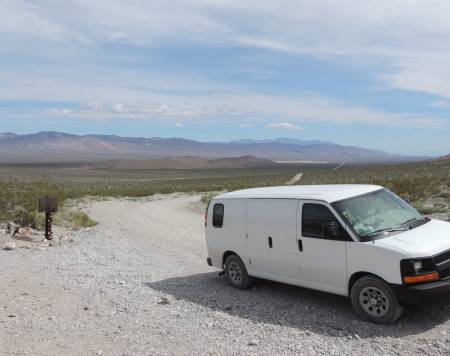
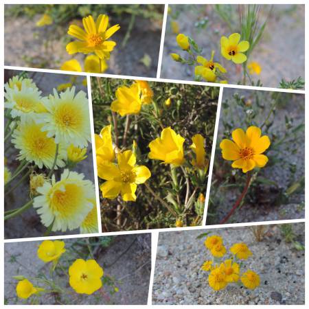
At this point of the trip we have no more reservations and have a week to get up to the Sacramento area. So we looked over the map and decided to try a new route out of Death Valley, heading north through Crankshaft Junction to Big Pine. We drove up to Scotty's Castle for the passport stamp and to check with the Rangers about the Big Pine Road. We were told it was fine for 2-wheeled cars, just a lot of washboard. It takes off from the road out to Ubehebe Crater. The road sign showed 75 miles to Big Pine and 35 mph. Definitely lots of washboard so I don't think we reached 35 mph too often. We made it to Crankshaft Junction - a true roadie experience! And the flowers were almost as good as when we entered at Salisbury Pass.
Crankshaft Junction and the road travelled

Flowers along the way

We made it back to civilization, Big Pine, by late afternoon. We continued on US 395 south to Independence and the county park. A great campground about a mile west of the town, well away from the road noise. It is along a creek with nice shade. Picnic tables, fire pits, water, pit toilets and $10 a night. The view is spectacular!
Independence Creek

Sierra Nevada range - west view

Panamint Range - east view

Passport Stamps
Death Valley National Park - Scotty's Castle
Wildlife Sightings
Cottontail Rabbit
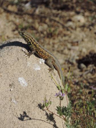
Lizard
Common Raven
Turkey Vulture
Swallow
House Sparrow
Mourning Dove
Last edited by Tom_H007; 03-07-2019 at 03:43 PM. Reason: Added map
RoadTrip Contributer
I, too, was pleased to see the Desert Five-spot, but I think I was struck by the luminescence lavender of the Mohave Aster.Originally Posted by Mark Sedenquist


Last edited by Pmount; 03-24-2015 at 08:08 PM. Reason: Photo url
RoadTrip Contributer
Wednesday, March 25, 2015
Start: Independence, CA
Finish: Red Rock Canyon State Park, Cantil, CA
Click here for this RTA Library Map
It stayed windy through the night, but not too cold, about 47 degrees in the AM. We had planned to eat breakfast in Independence, however the only cafe that serves breakfast is closed on Wednesday. We continued south on US 395 and stopped briefly at Manzanar National Historic Site. We have been here several times over the years and always come away learning something new about this period of history. A highlight of today's visit was a special art exhibit which was limited, but all were exceptional.
In Lone Pine we enjoyed a full breakfast at the Mt. Whitney Cafe, a place at which we have eaten over the years. A memorable breakfast was in the late 70s when we had to abort our climb of Mt. Whitney due to an early season blizzard. We had camped at 12,000 feet and woke up to howling winds and ice pellets. We hightailed down the mountain in record time to enjoy a meal at the cafe.
We spent several hours in the Lone Pine area letterboxing, including out at the Alabama Hills. The view of Mt. Whitney from there is spectacular.
Mt. Whitney

After a stop at the Eastern Sierra Inter-agency visitor center on the south edge of Lone Pine for a couple of stamps and t-shirt shopping we continued south on US 395 until we split off onto CA 14. At that point the flowers along the roadside became a carpet of many colors. We stopped for the night at Red Rock Canyon State Park which had plenty of flowers to keep me busy.
Flowers


Passport stamps
Manzanar National Historic Site - Independence, CA
Bonus
Eastern Sierra Interpretive Association
Ranger District - Lone Pine California
Wildlife Sightings
Collared lizard
Coyote
Common Raven
House Sparrow
Mourning Dove
American Robin
Hooded Oriole
Great-horned Owl
Swallows
Last edited by Tom_H007; 03-08-2019 at 08:10 AM. Reason: Added map
Wow, great flowers everywhere. I wish I could leave the office and go hunting myself!
Mark
RoadTrip Contributer
Thursday, March 26, 2015
Start: Cantil, CA
Finish: KCL campground (BLM), Carrizo Plain National Monument
Click here for this RTA Library Map
An early morning walk around the campground yielded more flowers! After breakfast we walked the mile-long nature trail near the highway. It had more geologic features than in the campground and the flowers were just as spectacular! The Great-horned Owl had roosted in a niche in cliffs above us and greeted the morning, as it did at dusk last night. Always a treat to hear and see.
Nature Trail -Red Rock SP

We continued on CA 14 to CA 58 and drove up to Tehachapi for the best gas price, $2.89. We paid the least in Tucson at $2.19 and the most in Baker, CA at $3.69.
Just beyond Tehachapi at Keene is the Cesar E. Chavez National Monument in Keene. It is a short drive off the highway to what was his headquarters as a farmworker's Union organizer. Inside the building is a display of his office, as it was in use. His office chairs was a rocking lawn chair. Outside is a memorial garden with his grave and a cactus garden plus shaded picnic areas.
Cesar E. Chavez NM

Instead of a picnic today we had lunch at the Keene Cafe. It looks rough on the outside, but well cared for inside with excellent food. The menu provides quite a bit of history of the area, including explaining that today's Ca 58 was US 466, which was considered a spur of US 66.
Keene Cafe

We continued west stopping in Arvin for groceries then crossed CA 99 and I-5 to follow CA166 to the town of Maricopa. Crossing the Central Valley of California at this time of year, the air is saturated with citrus blossoms. Finally turned north on Soda Lake Road to take us into Carrizo Plain National Monument (BLM). We stopped for the day at their KCL campground and enjoyed watching and identifying a variety of birds.
Looking across to San Andreas Fault - runs through Carrizo Plain NM

The night sky at all of our locations has been exceptional, excluding a couple of overcast nights. Most nights we have been able to see the Milky Way along with a multitude of constellations. The moon is just a sliver and high in the sky at dark.
Passport Stamp
Cesar E. Chavez National Monument- Keene, CA
Wildlife Sightings
Great-horned Owl
Northern Mockingbird
American Coot
House Sparrow
Common Raven
Mourning Dove
Rock Pigeon
Brewer's Blackbird
Western Kingbird
Last edited by Tom_H007; 03-08-2019 at 08:25 AM. Reason: Added map
RoadTrip Contributer
Friday, March 27, 2015
Start: Carrizo Plain NM
Finish: Buckeye Flats campground (NPS), Sequoia NP, north of Three Rivers, CA
Click here for this RTA Library Map
Great morning in camp birdwatching. Besides seeing the Western Kingbirds again, a pair of very colorful Bullock's Orioles came into the camp area. We left the campground and continued north on Soda Lake Road which became paved in a few miles. Along the way we saw a small herd of Pronghorn grazing.
Pronghorn grazing

At the visitor center I learned, what I already suspected, the wildflower bloom was early and nothing spectacular this year. We confirmed some of the bird sightings we had seen in the campground and along the way with the ranger. On the road in we saw several Loggerhead Shrikes up close.
Blunt-nosed Lizard at Carrizo Plain NM
We continued north through the monument then east on CA 58 back into the Central Valley, then north on CA 99 to Tulare and Visalia for a lunch, gas and grocery stop. On the way we stopped at Kern National Wildlife Refuge where we saw several birds unique to that area. Recently there was a report of a rare bird, Long-tailed Duck, which the office person had brought birders from all over. We thought we might have seen it, but not sure.
In Visalia we continued east on CA 168 into Sequoia National Park. Leaving Visalia we drove through Lemon Grove which was very fragrant with citrus blossoms. A wildflower report had stated that the flowers near Three Rivers, heading into the park were with viewing. We did not see much to report today. After a stop at the Foothills Visitor Center we drove up to Buckeye Flats to camp for 2 nights. Not only was the General Highway open through the park, but a loop up at Lodgepole campground was open. The weather report was for a low of 31 degrees up there, at 6700 ft. We opted for milder weather at 2800 ft. The 28 sites were full by 6 PM. We got the campground host site which was a bit more isolated and made for a wonderful site.
Redbud in campground

Passport Stamp
Sequoia National Park - Three Rivers, CA
Bonus
Carrizo Plain National Monument
Kern National Wildlife Refuge
Sequoia National Park - Home of the Big Trees
Wildlife Sightings
Ladybugs
San Joaquin Ground Squirrel
Side-blotched Lizard
Pronghorn
Rock Squirrel
Bullock's Oriole - male & female
Western Kingbird
Say's Phoebe
Common Raven
Red-tailed Hawk
Mourning Dove
California Quail
Loggerhead Shrike
Horned Lark
White-crowned Sparrow
Sage Sparrow
Great-horned Owl- heard
Northern Mockingbird
Little Egret
Flycatcher
Western Meadowlark
Northern Mockingbird
Brewer's Blackbird
Red winged Blackbird
Jay
Woodpecker - heard
Last edited by Tom_H007; 03-08-2019 at 08:54 AM. Reason: Added map
 Posting Permissions

 Reply With Quote