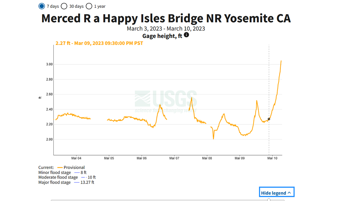
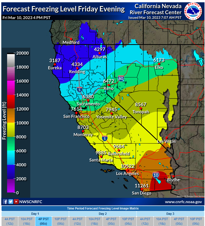
Compare the chart from Tuesday, February 28th with the one for today: Also set for 4pm PST. Look at the difference in the cold temperatures and why rain is falling and not snow right now!Originally Posted by Mark Sedenquist


Before May 1st
Between May 1st and 7th
Between May 8th and 15th
Between May 16th and 23rd
Between May 24th and 31st
Between 1st June and 8th
Between June 9th and 16th
Between June 17th and 24th
Between June 25th and July 1st
After July 1st

Compare the chart from Tuesday, February 28th with the one for today: Also set for 4pm PST. Look at the difference in the cold temperatures and why rain is falling and not snow right now!
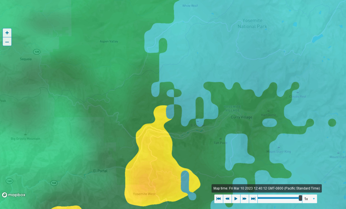
This is the latest rain/radar report for Yosemite Valley
So, still some snow falling on the upper elevations, but the valley is seeing heavy rain about now.
And it looks like fresh snow is falling on the Tioga Pass Road from Lee Vining all the way to Aspen Valley.
Mark

Rain, snow and thunder in the mix. Unsuprisingly there are warnings from the National weather service.
Yosemite NP remains closed and will do at least until Thursday 16th...FLOOD WATCH REMAINS IN EFFECT THROUGH WEDNESDAY MORNING...
* WHAT...Flooding caused by excessive rainfall continues to be
possible.
* WHERE...A portion of central California, including the following
areas, Bakersfield, Buena Vista, Buttonwillow - Lost Hills - I5,
Caruthers - San Joaquin - Selma, Coalinga - Avenal,
Delano-Wasco-Shafter, Frazier Mountain Communities, Fresno-Clovis,
Fresno-Tulare Foothills, Fresno-Tulare Lower Sierra, Grant Grove
Area, Grapevine, Hanford - Corcoran - Lemoore, Kaiser to Rodgers
Ridge, Kern River Valley, Kings Canyon NP, Los Banos - Dos Palos,
Mariposa Madera Foothills, Mariposa-Madera Lower Sierra, Merced -
Madera - Mendota, Piute Walker Basin, Planada - Le Grand -
Snelling, San Joaquin River Canyon, Sequoia NP, South End San
Joaquin Valley, South End Sierra Foothills, South End of the Lower
Sierra, South End of the Upper Sierra, Southeast San Joaquin
Valley, Tehachapi, Upper San Joaquin River, Visalia - Porterville
- Reedley, West Side Mountains South of 198, West Side Mountains
north of 198, West Side of Fresno and Kings Counties, Yosemite NP
outside of the valley and Yosemite Valley.
* WHEN...Through Wednesday morning.
* IMPACTS...Excessive runoff may result in flooding of rivers,
creeks, streams, and other low-lying and flood-prone locations.
Creeks and streams may rise out of their banks. Flooding may occur
in poor drainage and urban areas. Low-water crossings may be
flooded. Extensive street flooding and flooding of creeks and
rivers are possible.
* ADDITIONAL DETAILS...
- Heavy rain and snow melt anticipated.
- http://www.weather.gov/safety/flood
Dave
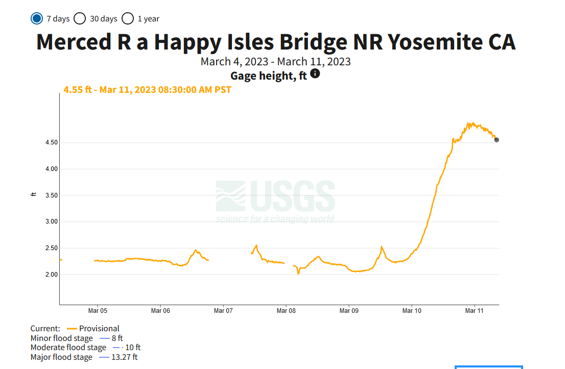
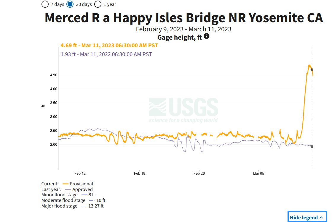
This is something I didn't expect -- that the water flow level would already be decreasing on the Merced River.
Captured at 8:30 am PST -- March 11th
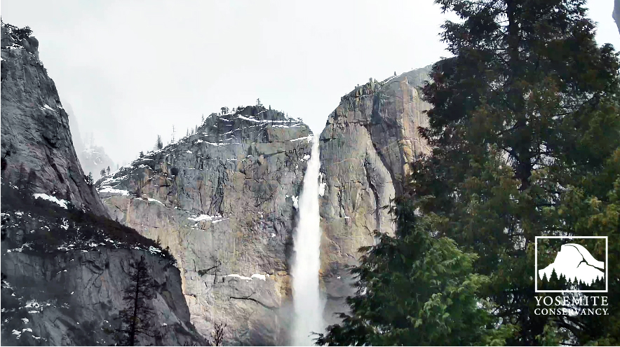
Yep, the waterfalls are ripping
Yosemite Falls from two minutes ago:
Watch it live here.
And this is kind of cool -- this is graph shows the period of March 5th to March 11 in 2021 and 2022.
The blue line is 2022. You can really see the difference from the melting snow this year.
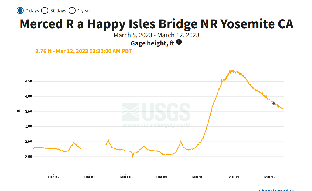
Water Levels Keep Dropping.
3:30 am March 12th
-----------------------------------------------------------
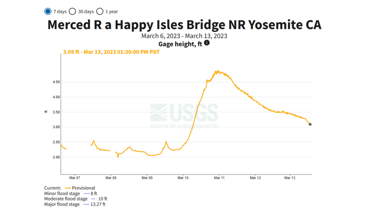
1:30 pm March 13th
------------------------------------------------------------
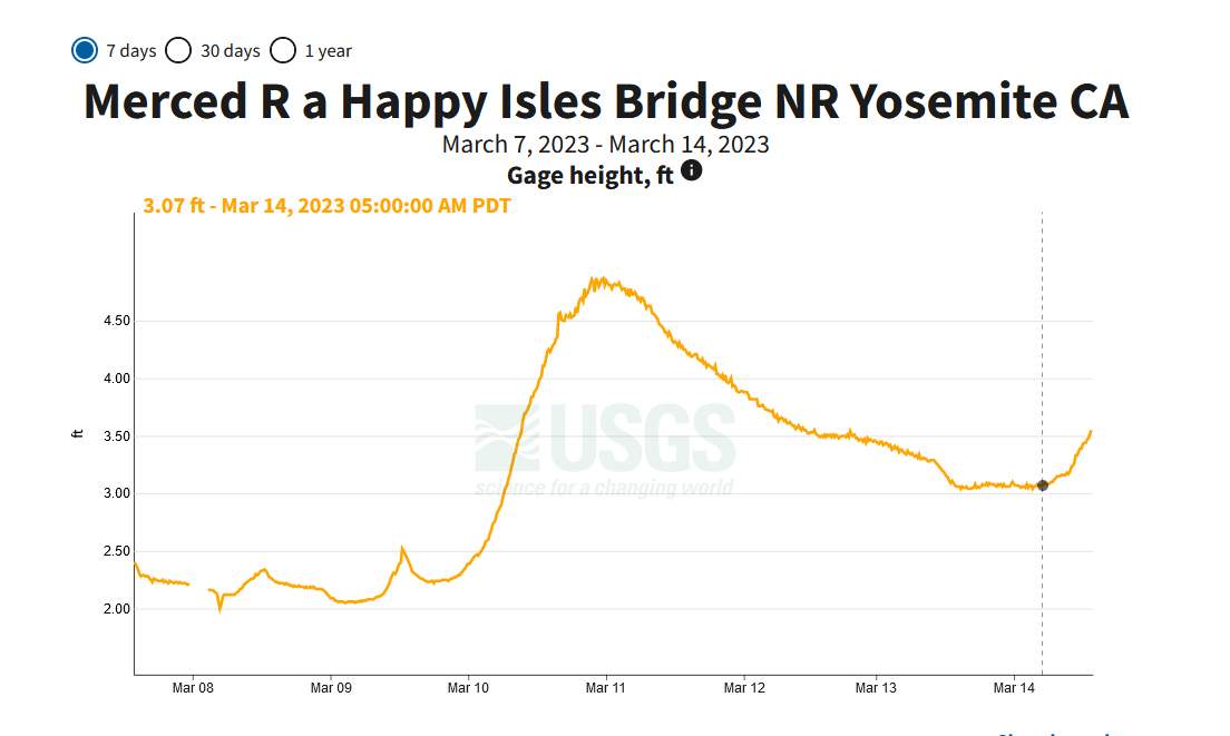
It is raining again in the valley and so the stream level is climbing again!
1:30 pm March 14th
------------------------------------------------------------
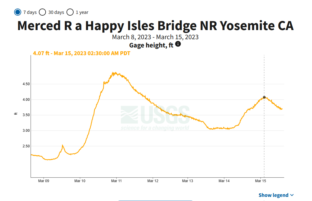
I really thought the flows would get higher. But maybe not.
2:30 pm March 15th
-------------------------------------------------------------
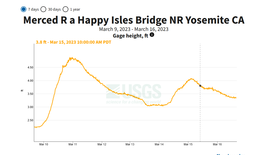
Still dropping!
3:30 pm March 16th
Last edited by Mark Sedenquist; 03-16-2023 at 04:07 PM.
Lots of snow falling on the high ground, up to 8 feet of new accumulation at 9000 feet with winds hitting 75mph ! I think the Plow crews are going to have their work cut out this Spring. Not just clearing snow, but also debris from fallen trees and rock slides !
Dave....WINTER STORM WARNING REMAINS IN EFFECT UNTIL 5 PM PDT
WEDNESDAY ABOVE 7000 FEET...
* WHAT...Heavy snow expected above 7000 feet. Total snow
accumulations in the storm of 2 to 4 feet from 7000 to 8000
feet. Total snow accumulations in the storm of 4 to 6 feet
from 8000 to 9000 feet. Total snow accumulations in the storm
of 6 to 8 feet above 9000 feet. Winds gusting as high as 75
mph.
* WHERE...Sierra Nevada above 7000 feet.
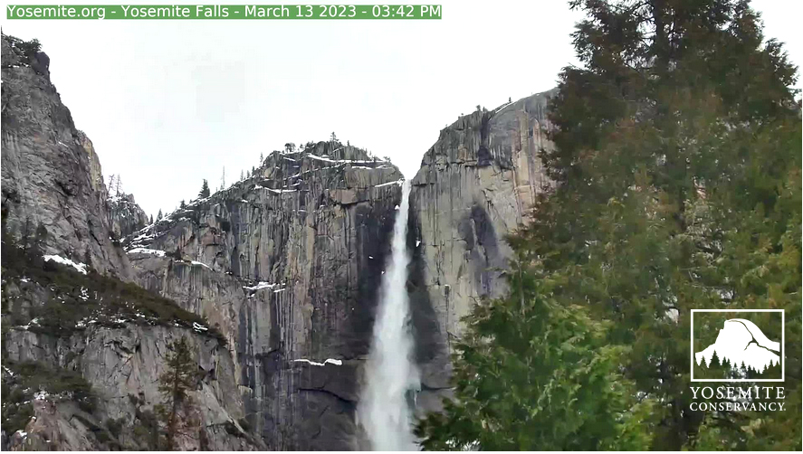
Wow, look at it go today!
March 13th at 3:47 pm pdt
-------------------------------------------------------------------------
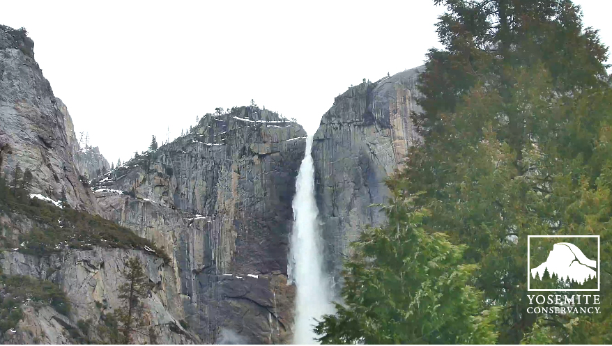
And look how gorgeous this is today!
March 15th at 3:38 pm pdt
Last edited by Mark Sedenquist; 03-15-2023 at 03:39 PM.
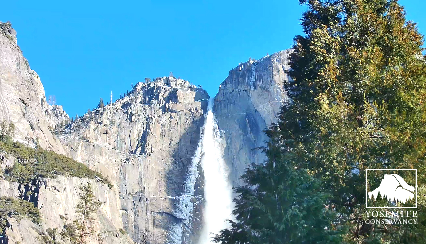
That is a spectacular image and it's worth checking out the Yosemite falls webcam on a full screen for the impact! I have stood at the bottom of those Falls when just a trickle, to be there now would be absolutely amazing ! For those that haven't visited the Falls, the overall drop is 2425 feet and during it's peak flow, a staggering 2,400 gallons per second can flow over the lip of the upper fall !! Can you imagine?!?
Dave
Look at it this morning with the frazil ice on the side and the blue sky!
March 15th at 8:50 am PDT
--Mark
Last edited by Mark Sedenquist; 03-16-2023 at 08:51 AM. Reason: Added a new photo
Yosemite NP opened up ' minimal' access to the Valley on Saturday after a great effort to plow pathed footpaths and restore limited services. The only access into the valley is via Highway 140.
Conditions are described as 'Very snowy' with advise to wear waterproof boots and traction devices because of ice on plowed pathways. Hiking on snow covered trails is not recommended.
Check before travelling if you are planning to visit as there is a lot more snow to come through Tuesday and into Wednesday and a Winter storm watch alert has been issued.
Dave...WINTER STORM WATCH REMAINS IN EFFECT FROM LATE TONIGHT THROUGH
WEDNESDAY AFTERNOON...
* WHAT...Heavy snow possible. Total snow accumulations of 1 to 4
feet possible. Winds could gust as high as 60 mph.
* WHERE...The Sierra Nevada.
* WHEN...From late Monday night through Wednesday afternoon.
* IMPACTS...Travel could be very difficult to impossible. Strong
winds can could cause tree damage.
 Posting Permissions
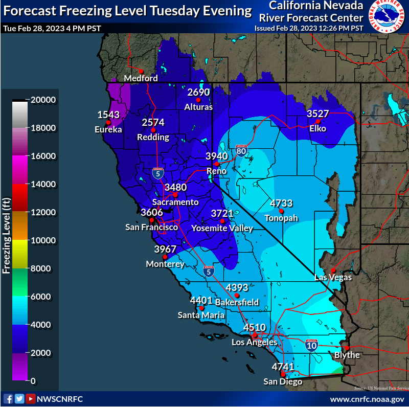 Forecasted for 02/28/2023
 Reply With Quote