 138 miles - about 5 hours
US Highway 7 (parts of which are known as the Ethan Allen Highway) is used travel the western side of Vermont from Champlain Lake, through maple syrup country, south to the Green Mountain National Forest. Along the way the route features covered bridges small museums, historic towns and villages that were established during the mid-1700s.
Here are some highlights along the route.
Burlington (Starting point)
Burlington is Vermont's largest city. It is located along Lake Champlain and the town is considered to be the Bass Fishing Capital of the U.S. Downtown Burlington is a pedestrian mall. Burlington is located at the crossroads of US Highway 2 and US Highway 7 and it is a two hour drive south of Montreal.
Vermont Wildflower Farm Store (mile 12)
The Vermont Wildflower Farm is located in the Champlain Valley on US Highway 7 (which is also called the Ethan Allen Highway) in the town of Charlotte. Just a few minutes west of the wildflower farm is the Essex, New York ferry, which offers a 15 minute ferry ride across Lake Champlain.
Mt. Philo State Park (mile 14)
Mt. Philo State Park is Vermont's oldest park, and a scenic drive to the top of the mountain overlooks the Lake Champlain Valley and New York's Adirondack Mountains.
Rokeby Museum, Ferrisburgh (mile 22)
Rokeby Museum is a National Historic Landmark. The museum offers an opportunity to learn about the Underground Railroad, which was used by slaves to migrate to free states. The museum has artifacts from four generations of the Robinson family, which owned this property from the 1790's to 1961.
Middlebury (mile 36)
Middlebury was settled just after the Revolutionary War and the village is listed on the National Register of Historic Places. Vermont's longest river, Otter Creek, passes through the center of Middlebury and a waterfall can be seen from the Battell Bridge. A marker honoring John Deere and his invention of the plow in located in Middlebury's Cannon Park.
Shoreham Covered Railroad Bridge (mile 50)
The Shoreham Covered Railroad Bridge was built in 1897. The small bridge spans the Lemon Fair River.
Brandon (mile 63)
Brandon is located at the base of The Green Mountains and it has 243 buildings on the National Register of Historic Places. This is an extraordinary place to view Vermont's stunning annual foliage displays.
New England Maple Museum, Pittsford (mile 68)
The New England Maple Museum is located in the middle of Vermont's Maple Country. Pittsford, which was established in 1761, is home to four covered bridges and a historic marker for the Vermont Sanatorium.
Wilson Castle, Rutland (mile 76)
Wilson Castle was built between 1867 and 1874. Wilson Castle features an 'after dark' series called Murder Mysteries Live! (dinner theater, scavenger hunt and reality game).
Green Mountain National Forest via VT Highway 7A (mile 108)
This route meanders through the Green Mountain National Forest using VT Highway 7A affording road trippers with gorgeous views any time of the year, but especially during the hardwood foliage 'bloom' of Fall!
Norman Rockwell Exhibit, Arlington (mile 122)
This exhibit covers the years Norman Rockwell lived in Arlington and it's where Rockwell's art started to depict small-town life. The town of Arlington is located in the Valley of Vermont between the Taconic Range and The Green Mountains. The Battenkill River flows through the center of Arlington.
Bennington (mile 138)
Bennington, which was established in 1749, has three historic districts that feature numerous walking tours. Bennington County is home to five covered bridges. Bennington is less than an hour drive from Albany, New York, and it is three hours from Boston, Massachusetts.
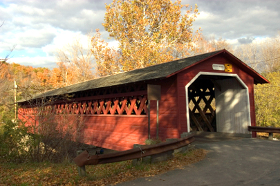
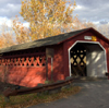
Henry Bridge, near Bennington, Vermont on a gorgeous Fall day
Photo courtesy of iStockPhoto.com / © Norman Reid