
Getting
Out There: |
Directory of all "Getting Out There" Articles> |
|
<Page
1 | Page 2
|
by Megan Edwards
[Map] [How to Get There]
|
(Continued from Page 1)
After a few more miles of twists and turns through a residential neighborhood with street names ripped straight from fairy tales (Red Riding Hood Trail, Peter Pan Road, etc.), I arrived at Rock City and found a remarkably good place to park in the large and mostly full parking area. Judging from the throngs walking toward the ticket booth with me, all of America and a good portion of the rest of the world feel as compelled as I did to SEE ROCK CITY.
A placard next to the ticket window explained my options, which included a ticket that would, in addition to Rock City, allow me to visit… Ruby Falls! They hadn't nabbed me on the way up, but what about on my way back down? No, thanks. Just Rock City, thanks. $14.95 got me a ticket and an enchanted map.
Although Rock City is perched atop a real mountain and boasts genuine, naturally-occurring rock formations, it's what archaeologists refer to as "disciplined." Everything in the place has been "improved" by human hands. That was the dream, apparently, of Rock City's original developers, Garnet and Frieda Carter, back in 1932. By planting gardens, building paths and bridges, and providing each rock formation with an appropriately evocative name, they created a roadside wonder just when cars and roadtrips were becoming a national obsession. They really didn't even need the gnomes -- but I'm getting ahead of myself.
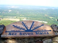
To tour Rock City, you just follow the Enchanted Trail. It routes you through, past, around, and across features like Goblin's Underpass, Shelter Rock, and Swing-A-Long Bridge until you arrive at last at Lover's Leap, the rock perch from which you can theoretically see seven states. Along the way, countless photo opportunities slow the progress of the migrating hordes, but I considered that a plus. The gardens are lovely, and all the trees and plants are nicely labeled. An enclosure houses several white deer, and the views of the surrounding countryside are quite spectacular.
As I continued along the Enchanted Trail, a dark sense of foreboding began to overtake me. Where were the gnomes? Gnomes were the one feature I had heard about, the one thing I knew besides the barn-side advertising campaign. Had I come all this way only to discover that gnomes had been erased from Rock City? The horror!
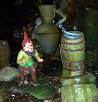
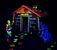
Fortunately, Rock City saves the best for last. The gnomes live on in the dark recesses of Fairyland Caverns, along with dozens of fairy tale and Mother Goose characters, all improved with plenty of Day-Glo paint. They frightened a few of the littlest kids, but everyone else seemed to love peering at a green and purple Snow White and an orange Humpty Dumpty. And the gnomes! There were plenty, dangling from swings above, making moonshine at their own little still, and standing around grinning in the dark.
As if by design, I ended up in the Rock City gift shop, where a popular souvenir is the birdhouse that says SEE ROCK CITY on the roof. I resisted, but now I almost wish I'd bought one. They really were cute.
Oddly, the trip back down the mountain was less than half as long as the upward journey. Later, I checked a map and had to smile at the clever positioning of signs that had led me to take a detour past Ruby Falls on the way up. I also almost wished I had succumbed to the parking lot attendant and stopped there. After reading about it online, I realize I missed a worthy roadside wonder. The incline railroad might be fun, too, so look out, Lookout Mountain. Someday, I just might be back.
Megan
Edwards
7/15/07
Rock City Gardens
1400 Patten Road
Lookout Mountain, GA 30750
706-820-2531
800-854-0675
Online: www.seerockcity.com
From Birmingham & Nashville:
Take I-59 north to I-24 east toward Chattanooga. Continue
on I-24 east until exit 174. Turn right onto US 64, 41 and
remain on US 41 until you come to the intersection of Broad
Street and Tennessee Avenue. Turn right onto Tennessee Avenue
and follow the signs to Rock City.
From Knoxville:
Take I-40 west until the I-40 & I-75 interchange. Take
I-75 south toward Chattanooga. At the I-75 & I-24 interchange,
take I-24 west toward downtown Chattanooga. Get off at the
Lookout Mountain & Market Street exit (178 south). Go
straight to the traffic light on Broad Street, turn left,
and follow the signs to Rock City.
From Atlanta:
Take I-75 north to Chattanooga. At the I-75 & I-24 interchange,
take I-24 west toward downtown Chattanooga. Get off at the
Lookout Mountain & Market Street exit ( 178 south). Go
straight to the traffic light on Broad Street, turn left,
and follow the signs to Rock City.
More "Getting Out There Articles>
|
|
Privacy Policy |
Copyright 1996 - 2025, RoadTrip America® - All Rights Reserved |
Contact RTA |