
Getting
Out There: |
Directory of all "Getting Out There" Articles> |
Road Trip to Old Nevada by Mark Sedenquist
|
Time machines are works of fiction, but a car,
a tank of gas, and Highway 93 are all it takes to travel back
to the Nevada of yesteryear. A trip north from Las Vegas to
Ely and Great Basin National Park is not only a 600-mile road
trip through ancient geological wonders, but also a journey
into the Silver State's wild and wooly historic past. Las
Vegas shrinks rapidly in a rear view mirror out past Nellis
Air Force Base, which means it's wise to stock a cooler before
setting out. Dining choices are as limited on the Great Basin
Highway as lovely spots to picnic are plentiful. Among the
most enchanting are the three small lakes that form the Pahranagat
riparian refuge. Ringed with cottonwoods, populated with water
birds, and amply furnished with shaded picnic tables, the
upper lake offers a delightful spot for lunch just off the
highway.
Just east of Crystal Springs, the highway bends to the east
and climbs over Oak Springs Summit to the picturesque railroad
town of Caliente, aptly named for the natural hot springs
in the area. From Caliente, the road passes through Meadow
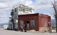
Valley Wash, past Rattlesnake Point, and on to Pioche, a mining
town with a serious reputation for wildness back in the 1860s.
A short detour on State Route 321 (which parallels Highway
93) offers a quick look at the historic town center, where
the "Million Dollar Courthouse" still stands. Originally
built in 1871 for $88,000, it ended up costing a million dollars
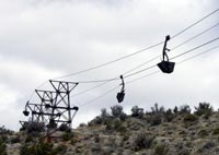
worth of state bonds. A reminder of the $40 million in silver
ore mined in the area, old ore cars still dangle from a tram
line that carried the ore down the mountain to the processing
mill on the valley floor.
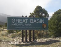
Nevada is the land of basin and range, and the next few miles bear ample evidence as the highway cuts through Lake Valley between sawtooth mountains on both sides. A pair of cottonwood trees at Pony Springs offers a nice roadside rest before the route heads up to Lake Valley Summit and, a few miles beyond, the junction with Highway 50, "The Loneliest Highway in America." Highway 50 rises over Sacramento Pass to the east, where signs point south on State Route 487 to the town of Baker and Great Basin National Park.
Next: Great Basin National Park, Lehman Caves, the Ward Charcoal Ovens, and Historic Ely>
Mark Sedenquist
September 3, 2006
More "Getting Out There Articles>
|
|
Privacy Policy |
Copyright 1996 - 2025, RoadTrip America® - All Rights Reserved |
Contact RTA |