
Getting
Out There: |
Directory of all "Getting Out There" Articles> |
Off-Road and Inside the San Rafael Swell, by Del Albright
|
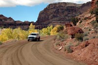
Fifty miles wide and 30 miles long of nearly undiscovered rugged landscape beauty, the San Rafael Swell area of Utah blew off my driving gloves! Wow, was I impressed.
Formed millions of years ago by geologic upheavals, this truly is a "swell" in the earth's surface. Uplifted craggy rocks have been beaten, battered and carved by erosion, wind and water to make this off-pavement SUV road tip one for the record book.
The area is loaded with table top mesas, little Grand Canyons, pinnacles and buttes. But you won't see many other vehicles. On a recent trip I entered the Swell on a cloudy, somewhat dreary day, and felt like I had absolutely left the real world behind.
Managed by the Bureau of Land Management (BLM) and patrolled also by the Emery County Sheriff's Office, you will see many sights familiar to visitors of other Utah parks and monuments. But you will see these sights in leisurely solitude.
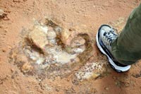
One special find on a recent trip was a full-size, bigger-than-a-shoe dinosaur track. It was an eerie feeling for me, standing on this sandstone ledge, maybe 15 feet up off the road under the rim of towering red rock cliff, looking at one single massive track from a big critter that lived millions of years ago. It's the only track there and it's weathering away, slowly but surely. I'll not soon forget the sensation of standing where this dinosaur walked, feeling my heart race just a bit, and finding myself looking over my shoulder…
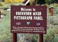
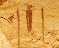
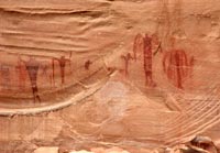
The pictographs of Buckhorn Wash were like none I've ever seen. Hundreds of figurines and odd shapes are painted on a stretch of red rock wall over 100 feet long. You park your rig within a few feet of the rock art. BLM signs help explain the symbols and what they might mean. I stood there in awe thinking of the story these ancient people were telling.
Officially called an anticline, the Swell is a kidney-shaped convex fold in the earth with a sequence of rock layers that are progressively older toward the center of the fold. Only one paved road crosses through the approximately 600,000 acres -- Interstate 70. Click here for an article about the I-70 view points along the Swell. And there are also plenty of good dirt roads to explore in the region.
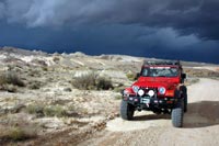
On a recent trip my partner and I learned a scary lesson about narrow canyons and flash floods. We drove our four-wheel drives up Black Dragon Wash, a rocky-walled skinny canyon with a sandy bottom, to see some marvelous pictographs. The further up the canyon we traveled, the more the canyon walls closed in on us.
It started out sunny and warm; but by the time we hit the end of the rough 4-wheel-drive road, the clouds were building and the sky was turning dark. It was obviously raining further up the mountain. We were in the path of whatever might happen.
Brains kicked in! As we made a hasty retreat out of the canyon, I brought up the rear in my Jeep. My partner in his Dodge truck called me on the CB and said, "Del, what's our plan if the deluge hits us?" My answer was simple, "Roll up the windows and hang on!"
Of course we were kidding with each other. But we were in a perilous spot. Fortunately we made it out just fine as the sky turned blacker and blacker behind our vehicles. The lesson we learned was clear: the desert weather changes very quickly and one should always have a plan - and an escape route.
IF YOU GO
The San Rafael Swell is a desolate place where you can find solitude in your SUV or on foot. But be prepared. Here are a few recommended travel tips:
- Travel with another vehicle and have overnight provisions in case of emergency.
- Tell someone your route of travel and have good maps with you.
- Carry plenty of water and a little grub.
- Do not camp or leave your vehicle in a wash or stream bed if it looks like rain.
- Stay out of rickety old mine shafts.
- Stay out of narrow canyons when rain is looming or falling in the higher mountains. Flash floods can be deadly.
Some Internet sites that are helpful in planning your trip to the San Rafael Swell include:
The San Rafael Swell is:
- 155 miles South of Salt Lake City
- 35 miles South of Price
- 17 miles East of Castle Dale
- 45 miles East of Salina
- 15 miles West of Green River
Map of San Rafael Swell
Del Albright
3/4/07
More "Getting Out There Articles>
|
|
Privacy Policy |
Copyright 1996 - 2025, RoadTrip America® - All Rights Reserved |
Contact RTA |