
Getting
Out There: |
Directory of all "Getting Out There" Articles> |
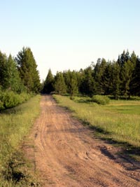
Summer Picnic on the Mesa Falls Scenic Byway
by Dennis Weaver
|
[Continued from page 1]
We reluctantly passed the Cave Falls Road heading to the east. The Cave Falls Road lines across the high country to the forgotten southwest entrance to Yellowstone Park. The road dead ends within the park and is a jumping off point for hikers and riders who wander through Bechler Meadows beyond road's end to see the park's lonely backcountry. It seems that only the locals have discovered this corner of the park in spite of rumors of big fish in Bechler Meadows.
We stopped where the road drops into the canyon to meet Henry's Fork. A small parking lot was crowded with locals launching drift boats. We chatted with a couple fishermen who hadn't caught much. I thought of a long glassy stretch a half-mile downstream, one of my favorite fishing spots. I fished it often and knew it well enough to know where the heavy rainbows were lying. Winter was my favorite time. The river is low and clear as the crisp air in the winter. Warm springs seep across the banks, melt the snow, and keep the margins green. Ducks and geese winter along these green edges, eagles cruise the airways, and deer from the high country winter along the river. Occasionally, a wintering moose wanders to the water.
There is a place where warm water drizzles off a cliff, seemingly suspended away from the rock. On a cold day, when the fly line is freezing in the rod guides, I often walk to the drizzle, wash the fish from my hands, and warm my hands in the water.
Three streams come together just upstream from the parking lot. Henry's Fork emerges from the deep canyon crease in the Yellowstone caldera. Robinson Creek rambles from the east and Warm River gracefully floats in from the northeast--three sizable streams all with very different characters. The local kids love to float the Warm River from above the campground in the heat of the summer. I tell Robert and Roberta how I had hiked far into the backcountry along Robinson Creek until there was no remaining sign of man and how I had caught fish effortlessly with small dry flies and watched for signs of bears.
Reluctantly, we passed the road that turned right to the headwaters of Warm River, another gravel road. The Warm River isn't really warm but it's a big spring and in the wintertime, it's much warmer than the air. In the cold air, steam rolls off the river giving the appearance that it is warm. A road winds to the river's origin where the river gushes from a hole in the mountain. There's an old house and the remains of a fish hatchery there. The house is now rented to travelers by the Forest Service. The description is intriguing enough that Robert reconsiders the fine print in his contract but decides to stay on the pavement.
The road passes spectacular overlooks of both the Warm River Canyon and the canyon of the Henry's Fork. We pull into a parking lot that overlooks Lower Mesa Falls. Much of the western portion of Yellowstone Park and the Island Park area lies within the giant caldera of an ancient volcano. The Henry's Fork of the Snake River, a sizable river, wanders across this caldera to plunge over the lip in three magnificent falls all within a mile. Lower Mesa Falls is the last of these. As we took pictures, we saw tiny colorful dots--people wandering along trails through the green below. Even after 11,000 miles, Robert is moved by the view.
In the distance, we can see Upper Mesa Falls.
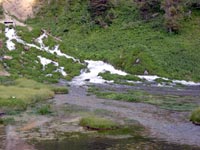
Sheep Falls is above that. I explained to Robert that one
day -- a very ambitious day -- my son Ben, my son-in-law Ben,
and I hiked downed to the river below Sheep Falls. The setting
was incredible with the roar of the falls as a backdrop and
mist hanging in the air. We carried our fishing rods and caught
fish but not the lunkers we had imagined. I explained to him
that the canyon walls were steep enough that even the locals
stay away and we had the canyon to ourselves.
More "Getting Out There" Articles>
|
|
Privacy Policy |
Copyright 1996 - 2025, RoadTrip America® - All Rights Reserved |
Contact RTA |