
Getting
Out There: |
Directory of all "Getting Out There" Articles> |
|
Page
1 | 2
|
| The rain clouds looming on the horizon did, in fact materialize into record-setting rain and floods, but not before road tripper Aaron Reed had a chance to look for wallabies and go kayaking on an ancient canal in western Texas. No canned mutton, though... |
|
We promised to take Tamara's friends Ann and Derek paddling way back in March, before the rains, before the rivers rose and raged all across Texas.
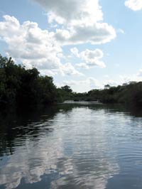
By early summer, the showers are sporadic. River levels on the San Saba near Menard look good, though. In fact, the spring-fed river west of town stays floatable all year long.
We don't know it yet, but the rain looming on the horizon as we drive west on U.S. Highway 290 from Austin will stretch well into July, setting one-day rainfall records again and again.
Just a few miles outside of Austin, the limestone hills begin to rise around us. After a jink north, Highway 290 takes us west again through Johnson City and into Fredericksburg. Settled primarily by Germans in the mid-18th century, Fredericksburg retains a significant bit of its European heritage, including lovely streetside biergartens and the Vereins Kirche, the community church built in 1847.
From Fredericksburg we continue west on Highway 290 to the little town of Harper. Just beyond Harper, a right on Ranch-to-Market Road 385 and a left down a graveled county road take us to Ann and Derek's 25-acre artists' retreat in the hills.
I'm on the lookout for wallabies. A few weeks earlier, Derek walked down to the county road to check the mail and was stunned to find one of the diminutive kangaroos lounging next to the mailbox.
Longhorns: check. Emus: check. Llamas: check. But wallabies, this day, are proving elusive.
Ann is suffering from a summer cold and begs off. Derek grabs his towel and a couple of bottles of homebrew, and off we go. I had thought to retrace our route to Highway 290, jump on Interstate Highway 10 for a few miles to Junction, and then head north on U.S. Highway 83 to Menard.
Derek suggests we continue north on Ranch-to-Market Road 385, up to London. Almost as soon as we get back to the hardtop we top a rise and there, spread out below us, is a magnificent vista of small farms and ranches and blue-shrouded hills folding in to the Llano River Valley.
At the London crossing of the river, we notice that water is flowing over the road. Just a few inches, and it is, after all, a low-water crossing. We drive on and just before London merge onto U.S. Highway 377.
Highway 377 takes us to another Ranch-to-Market
road, this one numbered 1121, and we follow that to State
Highway 29 west into Menard.
More "Getting Out There" Articles>
|
|
Privacy Policy |
Copyright 1996 - 2025, RoadTrip America® - All Rights Reserved |
Contact RTA |