
Getting
Out There: |
Directory of all "Getting Out There" Articles> |
|
Page
1 | 2
|
|
Dark rain clouds menace the western sky, and as we sit down for lunch at the Sideoats Café & Bakery, a heavy downpour commences.
The Sideoats is located on U.S. Highway 83, the main drag through the small town of Menard. It replaced Jay's Hamburgers, which I remember as a decent place to eat -- a place where I could get Blue Bell ice cream by the scoop.
This is now a wonderful place to eat. Prices are still reasonable - under $10 for most entrees - but the menu includes offerings like Cobb salad with grilled salmon, steak topped with blue cheese and thick Reuben sandwiches. Tamara and I both start the meal with a bowl of roasted eggplant soup.
As we finish our lunch, Derek asks the waitress if canned mutton is still available. A framed label on the wall advertises the product under the brand "Fort McKavett," the name of the U.S. Army frontier post (and now a state historic site) just up the road. The waitress checks with the café's owner, who returns to tell us: "Not in about 50 years."
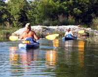
The rain has stopped and we head to my friend Brent Frazier's home on the other side of town. Brent runs San Saba River Adventures, a kayak guide and livery service in Menard. Brent won't be paddling with us this day, but he is providing kayaks and shuttle service.
We put in at the Bois d'Arc Road crossing (also known as "8-Mile" for its distance from town). The San Saba River, spring-fed and fast-flowing over limestone bedrock, is inviting.
"See you in about four hours," I say to Brent.
"Yeah … right," he answers. "Just start paddling like crazy if you hit the buzzard roost and it's after 6 p.m."
I'm notoriously slow on these streams.
But we do make it in time -- around the falls, under the heron rookery and past the buzzard roost. We watch clouds of butterflies mudpuddling along the banks and come across a dense stand of bluebells. A shortcut down "the ditch," an irrigation canal that started life as a Spanish acequia in the mid-1700s, gets us to our takeout early.
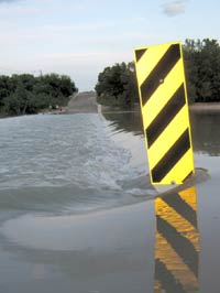
We retrace our route to Ann and Derek's. At the London crossing of the Llano River, county officials have placed a barrier across the road. We walk down to the edge of the raging stream, now pouring over the road in a cataract.
The Texas Department of Transportation safety slogan flashes through my head: "Turn around, don't drown." No way we're going to attempt to cross here. Derek gives me the bad news: We'll have to swing west and then south through Junction, a detour of about 60 miles, to reach his home though it is just a few minutes beyond the river.
Tamara and I arrive back in Austin just before midnight, tired from the day's adventure, full of the things we've seen and done. We're grateful, too, to have encountered no more downpours or flash flooding along our route.
The coming weeks will be filled with news of people forced from their homes, of cars swept away at low-water crossings and kayakers and rafters missing on the state's streams and rivers.
The much-needed rain that will end Texas' yearlong drought brings life, but takes it too.
Aaron Reed
9/9/07
(Links updated 8/6/20, RTA)
More "Getting Out There" Articles>
|
|
Privacy Policy |
Copyright 1996 - 2025, RoadTrip America® - All Rights Reserved |
Contact RTA |