
Getting
Out There: |
Directory of all "Getting Out There" Articles> |
by Robert Schaller
|
[VISITOR INFORMATION]
A field report from a road trip taken by Robert Schaller and Geneviève Lauzière in December, 2004
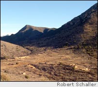
Apache Pass was a crossroads of human history in a place that General Crook once described as so barren "a wolf couldn't make a living on it." But there is a perennial freshwater spring there. The flow is just a trickle now, but it was once a reliable enough source that travelers made it a point to stop there. Good water sources were few in the southern deserts. The spring at Apache Pass was an important resource, and the Army built a post there in the 1860s to protect it: Fort Bowie.
The location was a flashpoint. The lush mountain setting was a favorite camping place of Apaches (and other travelers). Quite possibly, white Americans first met Cochise there. Teamsters stopped at the spring for water while freighting from the Rio Grande Valley to Tucson. The Butterfield Stage, America's first transcontinental stage line, built a stage station there. The Cochise War began (and ended) at Apache Pass, and the Apache wars were finally brought to a close altogether at Fort Bowie in 1886.
Fort Bowie is south of Interstate 10 in southeastern Arizona. To get there, my friend Geneviève and I drove from Phoenix to Bowie, Arizona, along Interstate 10 for about 220 miles. Then we took Apache Pass Road south about fifteen miles to the trailhead. After a picnic lunch, we donned our hiking boots for the walk to Fort Bowie. The day was a dramatic one, with a sometime sun creating shadows and contrasts through broken clouds. It was a perfect day for a hike and, as my friend can attest, I never tire of telling stories about Apache Pass.
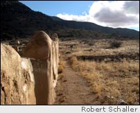
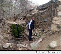
Along the trail, you'll pass the ruins of the Butterfield stagecoach station. The foundations of the stone building and adjacent corral can still be seen, and the ruts of the stage road are still visible nearby. You pass by the post cemetery and the ruins of Tom Jeffords' Chiricahua Apache Agency; Jeffords was perhaps Cochise's closest friend. Beyond the agency ruin are exhibits of an Apache wickiup and ramada, and then before reaching Fort Bowie, you'll pass the spring. It still creates a shady oasis. Click here for a map of the historic Butterfield stagecoach route.
Fort Bowie has not been "restored." After closure, local residents came and stripped it of useable materials. Over the years, the rains have washed away most of the remaining adobe walls. As a result, there is a mysterious or spiritual "feel" to it -- a feeling I've encountered before at places like Gettysburg, the Little Bighorn Battlefield, and the Alamo. You can almost sense the history as a tangible thing. Because it is a ruin, you have only your imagination to "conjure" what it was like there.
We spent a few moments looking around in the visitors center, talking with the ranger, and walking the perimeter of the ruins. You can see the foundation of the post commander's home, and you can pick out stones still visible today and match them to ones visible in old photos of the house. You can see the exact spot where Geronimo stood and had his picture taken after his surrender in 1886. You can see the parade ground, the Stars and Stripes still flying over it, and imagine a troop of tired cavalry men -- maybe even Buffalo Soldiers -- as they awaited an order to "fall out."
For the hike back, we trekked over the hill that stands over the Fort and looked down on the slopes where the Apaches staged the only "pitched" battle they ever fought against American troops. From their positions in the rocks above, the Apaches had a commanding view of the soldiers and were winning the fight until the troopers deployed a couple of small cannon they had with them. Rather than risk heavy casualties, the Apaches resigned and disappeared, melting into the landscape like rainwater after a desert storm.
Back in the truck, we drove westward over Apache Pass, stopping to look at the stagecoach road and sites associated with the Cochise War before heading home.
Bob Schaller
October 9, 2005
Other attractions in the area include
- Chiricahua National Monument
- Cochise's Stronghold in the Dragoon Mountains
- Tombstone
- Bisbee
- Kartchner Caverns
The best time to go is in the spring or fall when temperatures are mild. Winter is good too, when the weather is clear. The rangers have a permanent presence at the site, and if you think you might want to purchase books at the visitors center, consider carrying a small daypack for toting your purchases! The trailhead area has shaded picnic tables and a privy for visitors' convenience.
The ruins of Fort Bowie are reached by means of a moderately easy 1.5-mile hike (one way). Time for a short visit is about two hours, but a more thorough look requires three to four hours. Wear sturdy hiking shoes or boots, and carry drinking water. The return trip can be made on the same trail or on an alternative trail over the hill (recommended).
Accommodations can be made for persons needing
assistance under the Americans with Disabilities Act (ADA)
by contacting the rangers through the Fort
Bowie Web site . If you'd like more information about
visiting the area, you may contact the author of this article
at bob@roadtripamerica.com.
Click
here to view a National Park Service area map
And here
for a satellite view.
More "Getting Out There" Articles>
|
|
Privacy Policy |
Copyright 1996 - 2025, RoadTrip America® - All Rights Reserved |
Contact RTA |