
Getting
Out There: |
Directory of all "Getting Out There" Articles> |
In Search of Fall Color
by Dennis Weaver
|
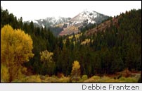
The early October skies were leaden and heavily settled on the mountains to the east as we headed up Highway 26 from Idaho Falls toward Jackson Hole, Wyoming. The rain had stopped. Cotton-like wisps clung to the mountains in contrast to the darker skies.
We were hoping to still find fall colors in the mountains. The storm had blown in from the south on heavy winds two days ago and we assumed knocked many of the leaves from the trees. Still, any road trip in the mountains is a good trip.
The roads in the high country would be muddy, but Debbie and Ben Frantzen and their little daughter were in a four-wheel drive truck. Merri Ann Weaver, our daughter Katie, and I were following in an SUV with good tires. In dry weather, those high roads would be passable in a passenger car.
The highway cuts across Antelope Flats, a high plateau overlooking the Snake River Valley. The grain on the plateau was harvested and we looked for geese in the stubble and watched a coyote scurrying for cover. The road dropped down into lush Conant Valley with its spring creeks and cattle farms and then crossed the South Fork of the Snake River into Swan Valley. Now that the harvests were over and the flows from Jackson Lake and Palisade Reservoir had been reduced, the river was low enough to expose the gravel banks and there were a couple of fishermen in the hole above the bridge. Rainey Creek, wandering across the floor of Swan Valley, was loaded with mallards and teal. Some tourists had pulled over to take pictures of a cow and calf moose feeding in the willows.
Below Palisades Dam, the road angles up the side of the valley to climb above the dam, on the south side of the reservoir. At the top, there is a sign: "Calamity Campground and Boat Ramp." We turned to the right. The road goes across the top of the massive dam holding back the waters of Palisades Reservoir. It's impressive to look down the river valley on one side and across the expanse of the lake on the other. The narrow road chisels through the cliffs on the far side. Even though it's paved, traffic creeps around the hairpin turns.
Calamity Campground was empty; the summer campers that fill the campground on many weekends were gone. On those summer weekends, boats line up on the concrete ramp and skiers and fishermen dot the lake. Since the lake stretches into Wyoming, it is never crowded, even on the holidays.
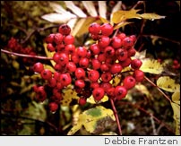
Above the campground, the road turns to gravel with a sign pointing to Bear Creek. We turned up the road, climbing above the lake. Many of the leaves were gone, but we were delighted to find enough remaining color to make the mountains strikingly photogenic. Where the trees thinned to expose the lake, we pulled over and Debbie took pictures. The air was crisp -- not cold -- and smelled of wet earth and pine trees and the pungent odors of fall.
[Continued on Page
2]
More "Getting Out There Articles>
|
|
Privacy Policy |
Copyright 1996 - 2025, RoadTrip America® - All Rights Reserved |
Contact RTA |