
Getting
Out There: |
Directory of all "Getting Out There" Articles> |
In Search of Fall Color
by Dennis Weaver
|
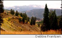
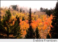
Beyond Jensen Pass, the road drops quickly to McCoy Creek. McCoy Creek, though paralleling Bear Creek in its run to Palisades Lake, has a different temperament. It's more open, with more willow flats and meadows. There are some nice campsites along the creek and fish in the stream. When McCoy Creek reaches Palisades, there is another campground, one that can be reached more quickly and in inclement weather from Highway 89 in Star Valley.
From McCoy Creek, the road follows the Palisades shoreline. Just before Highway 89, we stopped at the bridge over the Salt River at the mouth of Star Valley. The river is intriguing, and we watched for fish in the shadows of the dark waters. This time of year there should be big brown trout from the lake making their fall spawning run, but we didn't see any. We watched the ducks from the marshes along the river fly overhead.
On Highway 89, we turned left to Alpine Junction, a nice town that serves as an extended bedroom community to Jackson Hole. At the Junction of Highway 26 and 89, we could have turned right into Jackson Hole. Instead we headed back toward Palisade Dam, Swan Valley, and our homes on the Snake River Plains. We'll make that trip again next fall, maybe exploring side roads up dark canyons.
IF YOU GO:
Caribou-Targhee National Forest
You can drive all the way around Palisades Reservoir if you are prepared for back roads. It also makes a nice side trip on your way to Teton National Park and Yellowstone. Make sure your gas tank is full and your tires are in good shape. Allow four or five hours to make the side trip. Proceed with caution in wet weather and with recreational vehicles. The road through Jensen Pass is probably not appropriate for large RVs.
Both the Calamity Campground and McCoy Creek Campground have water and restrooms. The campsites along the creeks are primitive.
If you would like to see the Falls Creek waterfall
or the nearby campground, turn at the signed road at the
Conant Valley Bridge on Highway 26. The waterfall is just
a couple miles up the well-graveled road. Or with the proper
vehicle, you can try the loop mentioned in the article and
come down the Falls Creek road to the waterfall.
More "Getting Out There Articles>
|
|
Privacy Policy |
Copyright 1996 - 2025, RoadTrip America® - All Rights Reserved |
Contact RTA |