
Getting
Out There: |
Directory of all "Getting Out There" Articles> |
|
Page
1 | 2
|
| On an off-road trek along the Gulf of Mexico in southernmost Texas, Aaron Reed encounters many memories and a mystery. The memories are familiar -- fishing with his grandparents, nursing the injuries of a misspent youth -- but what is that orange stuff out in the water? |
|

Over the last 30-plus years, I've made the drive down Padre Island National Seashore… 90 times? A hundred? A hundred and twenty? I honestly don't know. A bunch of times, though -- from the earliest days of my childhood. This wilderness beach on the Gulf of Mexico, in the southernmost part of Texas, sometimes seems like a map of my life. It's here I saw the three coyote pups playing at the water's edge (1976), watched the sky darken with the flight of peregrine falcons (1983), punctured the air mattress, sleeping on sand (2006). I know this stretch of coastline well. It's a point I am at pains to make to Tamara as her frown deepens one Saturday in January.
"Really, I know what I'm doing," I tell her patiently. "There are no surprises for me down here … it's like my second home. We'll be fine."
I'm not making much headway.
"In South Carolina, we don't really drive on the beach," she tells me, again. South Carolina -- Folly Beach, to be specific -- is where her grandparents lived and the family still vacations.
"I guess I thought we were driving to the beach, then getting out."
"We'll get out," I assure her. "Let's just get to a spot where we'll have the beach to ourselves."
It's not hard to find that spot in what the National Park Service claims is the longest remaining stretch of undeveloped barrier island in the world. The park itself is 70 miles long, encompassing more than 130,000 acres of sand, grass, mud flats and stunted trees.
We're headed "down island," past the "4x4 Only" warning sign at milepost 5, all the way to the East Cut -- the southern end of the park. Depending on your point of view, it's 60 miles of nothing … or 60 miles of glorious wilderness.
"Everyone traveling down island should remember above all else that they will be in an isolated area many miles from the nearest facilities and possibly from the nearest person," warns the National Park Service.
It's part of the park's effort to make sure you get it: There are washouts, and treacherous deep sand, rattlesnakes, occasional narcotics traffickers, debris that could puncture your tires - or worse; what's more, cell-phone service is spotty or nonexistent. In other words, once you pass the sign, you're pretty much on your own.
Right. That's why we're here.
Getting there
We drive in from Austin on a Friday, after work, making the 200-or-so miles of our favorite route to the coast in about three and a half hours. Friday night we crash at the home of the hindmost Reeds -- the cadet branch of the family, my decade-younger brother, John, and his wife, Stephanie -- in Ingleside.
Saturday we wend our way through Portland and over to Corpus Christi. We stop at Academy Sports and Outdoors for a pair of shorts for Tam and a handful of fishing lures for me. We stop at the supermarket for snacks, then go through the drive-through at Whataburger for lunch. We cross the Laguna Madre on the JFK Causeway, and -- at the populated, northern end of Padre Island -- stop one more time for bottled water and gas.
Much to my surprise, there's a line at the entrance to the park. We pay $10 for a seven-day pass (the annual pass is only twice that), and I check the dry-erase board, scanning for highlights. Water temperature: 59 degrees. Driving conditions: fair. Debris: little. Seaweed: little. Beachcombing: poor. And, most importantly: High tide at 7:12 p.m., Low tide at 11:50 p.m.
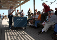
We stop in at the Malaquite Visitor Center, where a mostly-empty parking lot holds a couple of dozen vehicles bearing license plates from places like Nebraska and New Mexico, Kansas, New Jersey and Vermont. Texas, too, of course. On the deck, a volunteer is standing before a table covered with beach treasures, holding the skull of an Atlantic bottlenose dolphin. She's giving a "deck talk" to a group of what appear to be retirees. It's free, and part of the regular program here.
In the gift shop, we peruse a small museum display of astrolabes and anchors, stone points and fishing floats. A stuffed Western diamondback rattlesnake is coiled behind Plexiglas, as if ready to strike. A table displays a fiberglass replica of a Kemp's Ridley sea turtle laying eggs. The island is the major nesting site in the United States for the world's most endangered sea turtle.
A magnetic board on the wall reiterates down-island beach conditions. I note the time of the next high tide again and decide we'd better head out.
Memories and a mystery
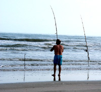
We take a left out of the parking lot and a short distance later the pavement ends. I click the trip odometer and we cruise at a sedate 15 mph past travel trailers and RVs nestled in the dune line. After the first five miles, after the warning sign, the beach becomes sparsely populated. Every mile or two we pass a hardcore surf fisherman or a family tent-camping above the high-tide line.
Then, at about mile 15, there is nobody ahead of us. We pull up next to a half-buried cable spool. It's buried the right way up and makes a dandy picnic table. Pete, our recently adopted Catahoula leopard dog, explores the area around the car. We break out the snacks and a couple of icy beers.
Legs stretched, tide line investigated, we load the dog and continue south.
We drive through the section of the island called Little Shell, and I have to pay attention. Up next: Big Shell, named for the polished and multicolored shell fragments piled on the beach here. Driving on this part of the beach is tough, and we're not in one of the mammoth, high-clearance four-by-fours most visitors favor here. While the tide is out, we can make good time on the hard-packed, wet sand near the water's edge. I cross up and over a couple of times, trying out the all-wheel-drive on the looser stuff near the dune line. If we come back while the tide's up, this route will be our only option.
Memories surface as we drive deeper into the down-island wilderness of the park. Somewhere along here, I think, is where my buddy Steve and I took turns towing each other through the surf on a kneeboard behind his Suzuki Samurai. That was, when? … 1985 or 1986.
And here, didn't there used to be an old Gulf shrimp boat on the sand, tossed ashore by a tropical storm?
Somewhere around milepost 25 we pass the spot where my 1978 Mercedes 240D finally bogged down. It was 1990, the summer between my first and second junior years in college. I was heartbroken after a relationship with a lovely girl had finally fizzled and wanted to "get away from it all." I had a surfboard and a cooler of beer.
It took about 24 hours -- sometime after the ice melted and the mosquitoes came out -- for me to realize I wasn't very good company to myself. Besides, the Gulf was flat as a mill pond. I flagged down a huge four-by-four truck, and the eight guys riding in the bed muscled my car out of the deep, soft sand. I drove back into Corpus Christi, hung a left, and somehow ended up in Tampico in the company of three guys from British Columbia.
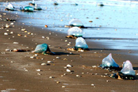
Mile 35.7: Tamara looks past me and points: "What's that, out there?"
I slow the Subaru and look out the driver's side window. On the second sandbar, a wave is breaking … orange. Bright orange. I stop the car.
"I have no idea," I say. "It's not red tide - wrong time of year. I don't see any dead fish. It doesn't stink. It kind of looks like paint in the water, doesn't it?"
But this clearly isn't that. [Read more>]