
Getting
Out There: |
Directory of all "Getting Out There" Articles> |
| The history of the Lone Star State - the history before the Kawakawa and Comanche, before the Spanish and the settlers from the East - is engraved in stone. Those rocks tell a turbulent story of environmental and biological change that makes the present-day "crisis" of global warming appear trivial. Aaron Reed takes the family on a road trip into the geological past, when parts of Texas now 1,500 feet above sea level were, literally, the bottom of the ocean. |
|
Driving 300 million years into the past takes longer than you might think, even if the destination is only 140 miles one way. It doesn't help if you get a late start.
Tamara, Patrick and I loaded Pete-the-dog into the trusty Subaru and headed north on U.S. Highway 183 about 10 a.m. one recent Saturday. Our destination: the Lake Brownwood spillway, a famed Pennsylvanian-period fossil-collecting site.
Fossil hunting, or "fossicking" as the Aussies call it, is one of our favorite family activities. For me, it's a holdover from childhood, when my father would take me out to the spoil islands dotting Aransas Bay and we'd find mastodon teeth, Glyptotherium (giant armadillo) scutes and fossilized sand dollars dredged up from 16 feet below the surface as the Gulf Intracoastal Waterway was being constructed.
Those remnants of Pleistocene-era megafauna are relatively recent; in fact, the last of the giant ice age mammals disappeared only about 12,000 years ago. Most of the fossils found in Central Texas are much, much older - dating back 60 million to 125 million years to the Cretaceous period -- and most are of marine animals: oysters, clams, starfish, snails, spiny urchins and their kin. That was also the age of the dinosaurs, but since much of Texas was under a great inland sea at the time, terrestrial forms are hard to come by.
Fossickers are typically cagey about their collecting locations. I'm not going to tell you, for instance, where I find those perfectly preserved "devil's toenails" (giant, extinct oysters) or where that cool shark's tooth came from, or even from which county road river crossing you can see the meandering tracks of the giant dinosaurs called sauropods. Some sites, though, are so extensive that decades of fossil hunting have not exhausted them, and so well-known that I'm unlikely to receive death threats for writing about them here.
Such is the Lake Brownwood spillway. A Lagerstätte of extraordinary richness, the site has yielded amazingly detailed specimens of sea urchins, starfish, crinoids and bryozoans for decades.
As we drive north, we take the new, U.S. Highway 183 tollway to bypass the sprawling Austin exurbs of Cedar Park and Leander, stop for coffee in the tiny farming community of Briggs, and continue on through Lampasas. We have been passing likely-looking road cuts for miles now - places where highway engineers have blasted through layers of ancient, fossil-bearing limestone -- and even though Cretaceous limestone is not what we're looking for, I'm itching to add a few specimens to my collecting boxes. North of Lampasas - almost to the town of Lometa, in fact - a tall ridge looms to the west of the highway.
"That looks pretty promising," Tamara says. "It looks like a big old reef."
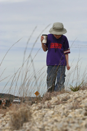
I agree, and we pull over onto the broad, grassy verge and pile out of the car. Patrick, my third-grader, is the first to make a find: a perfect sea urchin lying at the base of the slope.
As we work our way slowly across the embankment, it becomes clear that this is no ordinary site; the ground is literally, liberally littered with 100-million-year-old oysters from a genus called Texigryphea. Tamara picks up a curving, sutured plate - the outside of an ammonite shell. I find a small handful of the tiny, bead-like round urchins called Salenia mexicana.
Finally, with boxes and plastic bags full of fossils, we get back into the car and strike out again on U.S. 183, headed for Brownwood. We pass through Goldthwaite, famous for an early 20th-century jaguar and for the gold dust reportedly mixed into the asphalt of its highways. In Brownwood, U.S. 183 merges into U.S. 84 headed west. We eat a quick lunch at Schlotzsky's Deli - the only obvious eatery we can see from the highway - and then take a right on Texas Highway 279, and another on Farm-to-Market Road 2125. FM 2125 proves a pleasant drive through low, red hills and pecan groves before dead-ending at Spillway Road.
We take a right and stop at the Brown County Water Improvement District No. 1 office, where we check in and sign waivers that allow us to hike down into the spillway. I had checked the lake levels online before we left Austin; it's important to do so before setting out because any water coming over the low dam puts the fossil site off-limits. Following the lake patrol officer's directions, we drive down the hill and park in the designated area. A short walk across the low-water bridge and up a rutted track that meanders across a hill, and the gorge is spread out below us.
The thing that strikes me - after the surprise of just how deep the valley is and how rugged the terrain - is the colors. Alternating layers of limestone and shale paint the valley in reds, creams and greens. We clamber down into the first broad plateau of what must be a three-stage waterfall when the lake is overflowing.
Huge, red boulders are covered with the tracks and burrows of what must have been some pretty large critters - perhaps crabs, perhaps something else - and Patrick immediately finds a nice slab of limestone with crinoid stems and lacey pieces of bryozoan colonies embedded in it. As we work our way down, it becomes obvious that there has been considerable digging and chipping into the shale layers below some thick limestone overhangs. I concentrate my efforts there, and am soon rewarded with some small, irregular plates topped with the compressed remains of urchins.
It's midafternoon by now, time to move on to the Wilson Clay Pits.
Wilson's, as it is commonly known, is another Pennsylvanian site - an old quarry - where nearly all the finds are on the surface. The problem is finding the site. I had turned to Ed Elliott, president and field trip director of the Paleontological Society of Austin, and was following his directions.
Taken over the phone, the directions sounded like this: "Go left a few miles, come to a stop sign - the crossroad is 585. Go straight across. As soon as you get across the road it should be gravel. Very shortly, in a few hundred yards, you'll see a road that curves off to the right - go left. You will see a graveyard. Stay on that road. It winds back and forth, back and forth. Come across a creek and cross into Coleman County. Shortly after crossing Mud Creek, come back up and you should be able to see a good distance to either side. There's a crick in the road and a house on the left. Right when you pass that house, the quarry is on the right."
Following those directions, we find the site: huge mounds of red and green material heaped behind a barbed-wire fence. As we slowly drive past, reconnoitering, we spot two horsemen atop one of the hills. They wave, raising beer cans in salute, and I snap a quick photo.
"Do you think maybe you should tell them what we're doing here?" Tamara asks as I get back into the car. "Maybe they own the place."
Elliott had already explained that, though the quarry is in private hands, the owner of the defunct site welcomes fossil hunters and we should just crawl through the barbed-wire fence.
"Oh, I doubt they have anything to do with the place," I reply. "I'm sure they're just out for a ride." After all, seeing horses in Texas - especially in rural areas - is not all that unusual.
After collecting our gear and helping Pete-the-dog negotiate the pricking wire, we make for the nearest hill. It's liberally strewn with the stalks and spines of the flower-like crinoids, relatives of sea urchins and starfish that once anchored themselves to the ocean floor here. As we call out to each other about our finds, we're interrupted by the clatter of hooves as the two riders we've seen earlier come skidding down a slope.
"How y'all doin'?" calls one.
We introduce ourselves and it turns out, yep, P.J. and Wes (Wilson) are somehow related to the landowning family. Turns out, too, that Elliott was correct - they really don't mind folks coming on their land and hunting for fossils.
I offer P.J. a cold bottle of water, and he declines.
"Never while I'm riding," he says, then he reaches into a saddlebag and throws me an icy can of beer and pops the top on his own. We talk horses and "pop rocks" - the local term for crinoid stems - which contain pockets of unimaginably ancient water and explode when thrown into a campfire. At P.J.'s invitation, I take a spin on his gelding, a recently-wild mustang purchased in a federal auction. Then, his cell phone rings. Cows are out on another part of the ranch, and the two take off in a flurry of fossil dust.
We wander through the surreal landscape of clay pit tailings. I find a perfect, white crinoid calyx - the cup from which the animal's frond-like arms emerged. It is startling against the backdrop of deep-red clay.
As the sun sets, we head on down the blacktop,
connecting with Farm-to-Market Road 1716 before looping
back through Santa Anna and catching U.S. Highway 84 back
into Brownwood. We arrive back home before midnight with
a sleepy dog and a sleeping child, bits and pieces of the
ages packed away in plastic boxes and bags.
Aaron Reed
June 6, 2008
(Links updated April 25, 2020, RTA)
More "Getting Out There" Articles>
00|
|
Privacy Policy |
Copyright 1996 - 2025, RoadTrip America® - All Rights Reserved |
Contact RTA |