
Getting
Out There: |
Directory of all "Getting Out There" Articles> |
Gold, Ghosts & Glory Holes: The Historic Ruth Mine, by Joel Briggs
|
A side trip upon your next visit to the Death Valley area could include a visit to a rarely visited gold mine a few miles south of the park. The Ruth Mine, originally called the Graham-Jones Mine, started production in 1899 under the direction of Doug Graham and S.S. (Smiley) Jones. Situated in the Argus Mountain Range, it is located 14 miles north of Trona in Homewood Canyon. Elevation of the mine is 3,530 feet. The ore is "free gold" associated with pyrite in iron-stained quartz and "stringers" in quartz monzonite. Water is supplied to the mine by a 2-inch pipe from two springs one mile west in Homewood Canyon.
Over the years, Graham planted a grape arbor and a grove of athol (salt cedar) trees. Many are still visible today. It was not uncommon to find many of the locals spending the night at the arbor to escape the hot summer nights in the valley below and listening to Graham play the violin. Graham and Jones continued to work the mine until 1917, when Jones left leaving Graham to himself. Graham worked the mine alone until 1930.
Unable to pay the taxes, Graham got Fred Austin and Dr. Evans to grubstake him and pay the taxes on the mine. In return, Graham gave each person a one-quarter ownership of the mine. A few weeks later, Graham was robbed of his grubstake money -- $300 -- and died a week later.
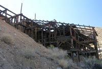
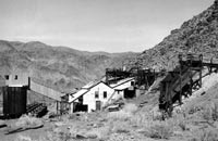
In 1937, The Burton Brothers from the famous Tropico Mine in Rosemond, California leased the mine from Austin and Evans. Within a few years, they installed a 40-ton cyanide mill, and the output was increased to 70 tons per day. To keep the mill running nonstop, they also leased the Davenport Mine, located three miles east of the Ruth. They also renamed the mine as the Ruth Mine.
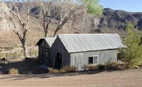
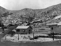
By 1941, the Ruth Mine was reported to have a population of 62 people with 25 workers employed. The residents built a small town complete with its own school district and general store. The schoolhouse opened with 22 students and even included an apartment for the teacher. The school stayed open until 1951. The general store also functioned as a makeshift saloon for special occasions and Friday nights. A mess hall was built with a seating capacity for 25 men and a bunkhouse to house them. Nearby mines including the Davenport, Orondo, and the Mohawk brought their ore here to be processed. Records show that over half a million dollars of ore was produced here during this period. The Ruth Mine camp was a busy place until 1942.
On October 8, 1942 the War Production Board under the Roosevelt administration issued order L-208. This order shut down all nonessential mining in the United States that was not related to the war effort. This order basically shut down all the gold mines in the United States. Overnight, the camp became a ghost town and the mine shut down. Attempts to restart the mine after the war were never successful. In the 1970s, the Ruth Mine shut down for good. Equipment was looted or sold off.
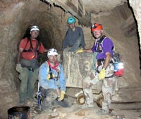
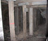
In 2003 Joel Briggs, Tom Worker, and Tom Dew spent two days exploring the mine and documenting the remaining artifacts there. There are six levels to the mine reaching a depth of 625 feet. Regrettably, the sixth level is under water and no longer accessible. During their exploration trip, they used over 600 feet of rock climbing rope, built temporary rope bridges and had to descend down glory holes over 150 feet high and 750 feet wide. They found ore cars, shovels, lanterns and hardware. Most notable was the timbering that supported flooring, walls and ceilings. In one tunnel, they counted over 12 ore chutes and enclosed timbered tunnel that was over 120 feet in length. Further investigations revealed that the timbered tunnel was built on the wall of a glory hole.
In 2004, the U.S. Bureau of Land Management (BLM) attempted to bring the mining site into the Adopt-A-Cabin program by hosting a "Take Pride in America" event in January. The Adopt-A-Cabin program, started in 1989, is a successful partnership through which the BLM supplies materials and volunteers provide the labor to repair historic cabins once used by miners and ranchers in the southern California area. The event was a great success, and over 120 volunteers came out and participated. Over 3 ½ tons of trash and other debris was removed from the site, but liability issues and conflicts between the mine owner and the BLM ended that program about three months later. Today, an active volunteer group is working with the mine's owner to restore the area.
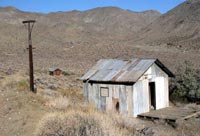
In 2005, the wet winter caused the main tunnel to collapse partially. It was determined that the mine was unsafe, and the mine's owner wanted no one else to go in. Today, the Ruth Mine property continues to be privately held but is open to the public. It is slowing being restored. Visitors can walk around and tour the old mill and the few remaining buildings, including the saloon and the school house. The mine is under lock and key and is not open to the public. Camping is permitted and picnic tables and fire rings are available.
Getting There: To get to the Ruth Mining Site, take California Highway 178 to Trona. Go another 10 miles north of Trona, and turn left on Homewood Canyon Road. Go another five miles, staying to the right. The mine site will be at the end of the paved road. The gate to the mine site is locked, but you can park your car and follow the path to the kiosk board. Please respect the no trespassing signs near the caretaker's home. The road leading to the mine is paved, but for the the last half mile, watch out for potholes.
Benchmark
Map: California (pg.95 A9)
Joel
Briggs
3/11/07
 Joel
Briggs is an avid part-time archaeologist who has
turned soil at the Lost City of Caral in Peru, ventured
deep into the Sahara Desert to find lost ruins, and is
currently surveying and documenting many Native American
prehistoric trails that wind through California's deserts.
He is a regular tour guide for the Coso Petroglyphs located
within the China Lake Naval Weapons Center. On any given
weekend, you can find Joel in his FJ40 Land Cruiser, exploring
Death Valley, Baja California or somewhere else he can
learn about hard rock mining. Joel was the inspiration
for an RTA roadtrip to the
former mining camp at Skidoo in Death Valley. Joel
is currently pursuing a master's degree in Archaeology. Joel
Briggs is an avid part-time archaeologist who has
turned soil at the Lost City of Caral in Peru, ventured
deep into the Sahara Desert to find lost ruins, and is
currently surveying and documenting many Native American
prehistoric trails that wind through California's deserts.
He is a regular tour guide for the Coso Petroglyphs located
within the China Lake Naval Weapons Center. On any given
weekend, you can find Joel in his FJ40 Land Cruiser, exploring
Death Valley, Baja California or somewhere else he can
learn about hard rock mining. Joel was the inspiration
for an RTA roadtrip to the
former mining camp at Skidoo in Death Valley. Joel
is currently pursuing a master's degree in Archaeology. |
More "Getting Out There Articles>
|
|
Privacy Policy |
Copyright 1996 - 2025, RoadTrip America® - All Rights Reserved |
Contact RTA |