
Getting
Out There: |
Directory of all "Getting Out There" Articles> |
The Most Boring Highway in America
by Robert Schaller
|

I had to work in Yuma, so I drove from Phoenix the night before. The romance of a road trip is intense at night. It's you, your thoughts, maybe a companion, the dash lights and radio, in an electromechanical bubble shooting along alone in the dark. There are other cars and trucks, but they exist in their world while you are alone in yours. I've always loved driving at night.
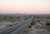
I returned in sunlight. Eastbound Interstate 8 rises uphill as it leaves Yuma. Paralleled by the railroad it goes over Telegraph Pass, then down across an agricultural valley past Wellton, over another range, then past Gila Bend to a junction with Interstate 10 at Casa Grande.
The terrain is rolling desert punctuated by mountain ranges. On a clear day, the colors are sharp - browns, blacks, reds, purples and blues, all contrasting with the brown and gold shades of the mostly-dead desert grasses and the greens of the shrubs and scrubby trees. Things are still dry from last summer's heat. The mountains' chiseled ridgelines, domes and spires starkly define the edge of a clear blue sky. You can see detail on mountains 60 to 80 miles away - maybe farther. Of course there are days when wind, dust or glare blur the crisp visibility and the contours of distant mountains. Heat sometimes shimmers off the desert floor in visible waves. Drivers on this road generally blaze through all of this at 70 to 80 miles an hour or faster.
The scenery was one distraction among many. I passed Dateland, where travelers used to jump into irrigation pools, clothes and all, to find relief from summer heat back when refrigeration in automobiles wasn't common. While Dateland has always been an oasis, many travelers found it preferable to cross this desert at night. Then and now, you can find treats in the gift shop and café made from locally-grown Medjool dates.
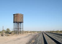
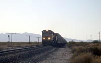
Dateland was a railroad stop in the days of steam - the locomotives had to replenish their water supply frequently. You can still see a water tank left over from those days at milepost 73 -- it sits along the tracks by the south-side frontage road. Freight trains have run this route night and day for over 100 years, but passenger trains are mostly gone now. A lot of WWII soldiers came this way, riding the trains to their embarkation points. General Patton trained soldiers nearby.
Like many interstate routes, this has always been a highway. Interstate 8 and the railroad follow the tracks of a stagecoach route across the southern Arizona desert. Before that it was a wagon road and an Indian trade route. The path followed water. The Gila River flowed year-round before diversion dams dried it up this far downstream. Many of the communities along the way got started as stagecoach stations. Others sprang up as the railroad reached this area.
Near Gila Bend, you reach another island of agriculture. You see huge tractors and crop dusters working day and night, using floodlights to illuminate their way. I saw hayfields with new green grass, and cotton in large bales from last fall awaiting shipment to the mills.
Next: Spot Road, Black Rocks and Gila Bend>
Bob
Schaller
January 29, 2007