
Day Trips
Directory of all Day Trips>
Tucson: Gateway to Southern
Arizona
by Jaimie Hall-Bruzenak
|
The area around Tucson, Ariz., has been inhabited for thousands of years, and not just by roadrunners and rattlesnakes. Day trips from Tucson can introduce you to the rich history of this region, from early Native American sites all the way to the Space Age. You can also experience the ecological diversity of this part of the state, which ranges from lowland deserts to mountain forests and includes species of tropical birds and plants usually found farther south.
Your time and interests will dictate which direction to head. Just remember that wherever you go, and no matter what time of year, always carry water in your vehicle.
Spanish heritage and mountain byways
166-mile loop trip
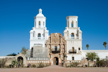
In 1774, the king of Spain sent Juan Bautista de Anza, captain of the presidio of Tubac, on an exploratory expedition to scout out a new route to San Francisco. The Juan Bautista de Anza National Historic Trail includes three historic sites south of Tucson off Interstate 19. At Exit 92 you'll find Mission San Xavier del Bac; the white mission is easy to spot against the brown hills of the surrounding Tohono O'odham reservation. Continuing south on I-19, you'll come upon Tubac Presidio State Park, which marks the start of Anza's expedition. Four miles south of the park, along Frontage Road, is Mission San José de Tumacácori, which was founded in 1691 by Father Eusebio Francisco Kino and is now protected as a national historical park. The town of Tubac has dozens of galleries and shops offering colorful Mexican goods. Wisdom's Café, a restaurant located just north of the mission, is known for its excellent Mexican food and fruit "burros."
If you continue south toward Nogales, you can make a loop drive through an outstanding recreation and birding area. Pick up Arizona Highway 82, which will take you through golden grasslands to Patagonia, an appealing small town with a picnic area, galleries and shops. Nearby Sonoita Creek Natural Area and adjoining Patagonia Lake State Park are good birding and hiking areas. At Sonoita, turn on Arizona Highway 83 then left on Arizona Highway 6, also known as Greaterville Road, which will take you over a scenic but narrow, mostly dirt mountain road to Madera Canyon, a premier birding area within Coronado National Forest. In spring and summer you might even spot an elegant trogan, an astonishing bird with an iridescent green head and bright red belly. Madera Canyon is also accessible from a paved road off I-19 at Exit 63.
Cactus, copper and the night sky
318 miles
A drive west to Organ Pipe Cactus National Monument and the town of Ajo makes a nice day trip for natural science lovers. Follow Arizona Highway 86, Ajo Way, through the Tohono O'odham reservation to the curiously named town of Why. Head south on Arizona Highway 85 and you'll come to the national monument; head north and you'll come to Ajo. The tiny town is named for the "Y" intersection of the two highways.
Organ Pipe has a number of interesting cacti and other desert plants growing at their northernmost limits. Its namesake, the organ pipe cactus, towers up to 23 feet overhead; its thick branches look like pipes in an organ. The 21-mile Ajo Mountain Drive loop, to the east of the highway, takes you through several plant communities on a windy, graded dirt road. The park is located on the border with Mexico; check at the visitor center for closures and safety precautions. Autumn, winter and spring are good times to visit; summer can be brutal.
Thirty-five miles north of the park is the small
mining town of Ajo.
A huge open-pit copper mine, the New Cornelia, dominates the
landscape. The company stores you see around the plaza were
built around 1917. Be sure to drive up Indian Village Road
to overlook the mine and to visit the Ajo Historical Society
Museum in the old St. Catherine's Indian Mission to get a
sense of the area's history. You'll find a few shops at the
plaza and more located farther north on Highway 85.
Returning to Tucson on Highway 86, plan to stop at Kitt Peak
observatory for the nightly observing
program. Visitors learn how to use a planisphere, a kind
of star chart, and observe the sky both through binoculars
and through one of the reflecting telescopes. Reservations
are necessary; the fee includes a light meal. Transportation
can also be arranged from Tucson.
Contrast of the ages
160-mile loop trip
This day trip to the northwest of Tucson is a mind-boggling time-travel adventure that includes the ruins of a prehistoric Indian culture, the site of a World War II Italian POW camp, and an experimental research station worthy of science fiction.
Before the Spanish missionaries arrived, a community of up to 3,000 Native Americans, known as the Hohokam, lived in the Coolidge area north of Tucson in several villages. They practiced extensive irrigation, grew corn, beans and squash, and built dwellings of caliche, the native clay, rather than adobe or stone. The remains of one of their villages is preserved at Casa Grande Ruins National Monument, which lies about 70 miles north of Tucson off Interstate 10 and Arizona Highway 87. Casa Grande, "large house," is the name of the largest structure. Since 1932, it has been protected from erosion by a steel canopy. Though caliche dries rock-hard, it is susceptible to erosion over time.
Leaving Coolidge, drive east to Florence. You can pick up a map for a walking tour of the town's old homes at the Pinal County Visitor Center. The Pinal County Historical Museum, on Main Street, has an exhibit depicting the large Italian POW camp located there during World War II. Most of the prisoners were captured during the North Africa campaign, and some of them immigrated to the U.S. after the war ended.
Traveling south from Florence to Oracle Junction on Arizona Highway 79, keep your eye out for the roadside marker showing where Tom Mix was killed in an automobile accident in 1940; you'll find it between Mile Markers 115 and 116. At Oracle Junction, head east toward the town of Oracle. Here you will find Biosphere2, a glass-enclosed, experimental ecosystem that was built in the late 1980s. In the early 1990s, eight crew members lived for two years in the sealed structure. The biosphere was designed to be totally self-sustaining, but it did not achieve its goals and a second mission was aborted after a few months. Now it is open to both guided and self-guided tours.
Sky Island Scenic Byway
41 miles one way
A short 40 miles from Tucson - and yet worlds away - is a scenic highway that takes you from lowland desert to alpine forest in the course of just 27 miles. As you climb to 9,100 feet in the mountains of Coronado National Forest, you'll find plants, animals and geology that exhibit some of the most wide-ranging natural diversity to be found in any area of comparable size in the continental U.S. It's like taking a trip from Mexico to Canada in one day. The General Hitchcock Highway, better known as the Catalina Highway, begins east of Tucson and takes you high into the Catalina Mountains, opening up incredible views of the city below. Along the way are scenic viewpoints, picnic and camping areas, and hiking trails.
The Palisade Visitor Center at Mile 19.6 has maps and books and nearby restroom facilities. The village of Summerhaven at the end of the road has visitor services. Take your camera and a lunch. The hoodoos and other geologic features beg to be photographed. While this drive can easily take a whole day, your Forest Service pass is also good at Sabino Canyon Recreation Area, at the foot of the Catalina Mountains on the edge of Tucson. As you're returning to the city, take North Sabino Canyon Road, then hike up the canyon or ride the shuttle bus all or partway.
Cowboys and Indians
173 miles one way
To the east of Tucson, off I-10 to the south, is rugged country that was home to the Chiricahua Apaches in the 19th century. From here, Apache leaders Cochise and Geronimo led raids on ranches, attacked stagecoaches, and harassed miners, evading capture by U.S. soldiers for many years. Several points of interest give you insight into this time period as well as the ranching history of the area.
A stop at the Amerind Foundation, located in Texas Canyon in the Little Dragoon Mountains (Exit 318), will give you some background. This private, nonprofit museum and research foundation houses 21,000 pieces, one of the finest private collections of Native American art and artifacts in the country.
Another stop is Cochise Stronghold in Coronado National Forest, off U.S. Highway 191. You can hike Cochise Trail #279 into the canyons that were his refuge. You can also view the rocks of the stronghold from the Stronghold Nature Trail in the campground.
Continue east to Willcox, where the Rex Allen Museum and the Willcox Cowboy Hall of Fame will give you a flavor of the region's cowboy history, then south to Chiricahua National Monument. The pinnacles, columns, spires and balanced rocks give you a sense of how this rugged country helped the Apaches evade capture for so many years. Drive the eight-mile scenic drive or hike one of the many trails. This area is a meeting place of four ecological regions: two deserts (the Sonoran and the Chihuahuan deserts) and two mountain ranges (the Rockies and the Sierra Madres).
Also located within the park is Faraway Ranch, which was homesteaded by Swedish immigrants Neil and Emma Erickson in 1887, shortly after Geronimo surrendered. Neil Erickson had himself served as an Indian fighter in the U.S. Army before settling down to ranching and a career with the new U.S. Forest Service. Times changed. Later generations of the family operated the ranch as a dude ranch, and the property was sold to the park in 1978. Like much else in southern Arizona, Faraway Ranch tells an unexpected tale of people from all over the world, all determined to live and prosper in this demanding but beautiful environment.
Jaimie Hall-Bruzenak
1/23/09
(Links updated 2/11/23, RTA)