
Day Trips
Directory of all Day Trips>
Six Day Trips from Phoenix
by Jaimie Hall-Bruzenak
|
If you thought Phoenix was surrounded by flat, sandy desert, you are in for a surprise. True, there is a desert here, but it is a lush desert where tall saguaro cacti tower over mesquite, ironwood, creosote, and many smaller cacti that bear vibrant blooms. Hillocks and mountains break the view, and distant mountains promise cool forests of ponderosa pines.
Arizona's landscape is varied and beautiful, and you can see a lot of it in a series of day trips out of Phoenix. Here are six good ones.
Under the Mogollon Rim
240 miles, 4.75 hours
This all-day adventure takes you through gorgeous scenery up to Arizona's mountain country below the Mogollon Rim. Travel via Arizona Highway 87 and return via Interstate 17 to avoid rush hour traffic. Be advised that there is only one rest stop on Highway 87.
Highway 87 climbs up and down a series of mountains,
winding through rugged, rocky terrain. Giant saguaros grow
on steep south-facing slopes. In Payson,
Highway 260 joins Highway 87. The rim looms above the towns
of Payson, Pine and Strawberry. There are several good places
to stop and explore.
- Zane Grey fans: Stop to see a replica of the Zane Grey cabin on Main Street in Payson; the original burned in the Dude fire in 1990. (The cabin is closed Tuesdays.)
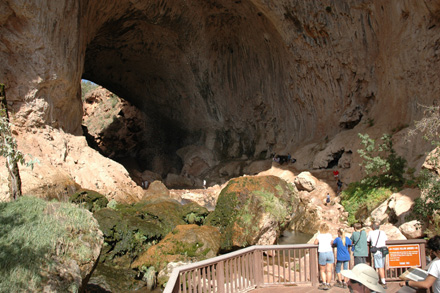
- Stretch your legs at Tonto Natural Bridge State Park, about 10 miles north of Payson. Turn left off Highway 87/260 onto Forest Road 583. Hike down the Gowan Trail underneath the bridge or take one of the shorter trails above. If you pick up a sandwich in Payson before you go, you can have a picnic in the park.
- Visit the Pine-Strawberry Museum in Pine; hours are limited.
For an eat-in lunch, try either the Small Café in the Twin Pines Shopping Center in Payson or the Randall House on Highway 87 in Pine. HB's Place in Pine is good if you are in the mood for a hamburger, and the Strawberry Lodge in Strawberry has delicious desserts.
To return to Phoenix, continue following Highway 260 west to Camp Verde, then take I-17 south to the city. The rest area at Sunset Point has good views; as you approach, you might even see some pronghorn antelope.
Gallery hopping in Scottsdale
18 miles, 20 minutes
It takes only a few minutes to reach Scottsdale from downtown Phoenix, but visiting the many art galleries in its Old Town district can occupy you for the rest of a leisurely day.
To explore Old Town, park your vehicle and then make your way to the intersection of Scottsdale Road and Main Street. The three blocks of shops on the east side of Scottsdale comprise the Old Town District; the galleries on the west side and along Marshall Way (paralleling Scottsdale) make up the Arts District. The variety and quality (and prices!) of the art found in the galleries are astounding. For lunch, local friends recommend The Grapevine on Brown Street, Oregano's Pizza and Pasta Brioni.
After exploring Old Town, drive six miles to Cosanti,
the home and studio of Paolo Soleri, whose beautiful wind
bells and wind chimes are famous throughout the Southwest.
The buildings at Cosanti represent bioclimatic architecture,
which uses design and architectural elements rather than mechanical
systems to achieve thermal comfort inside. Cosanti's innovative
construction makes use of earth-casting techniques and careful
solar orientation for a pleasant environment all year round.
Sales of wind bells in the gallery are used to support Soleri's
experimental city Arcosanti,
which is built on principles of "arcology" (Soleri's
vision of a combined architecture and ecology); it lies about
70 miles north of Phoenix, and is worth a trip another day,
if time permits. Cosanti is open seven days a week; self-guided
tours are available anytime; donations welcome.
Desert flora and fauna at Boyce Thompson
Arboretum
62 miles, 1 hour
The variety of plants that grow in the desert is incredible, and you can see a lot of them at Boyce Thompson Arboretum, located in Superior, east of Phoenix. The arboretum, which covers 320 acres, is crisscrossed with trails that lead through gardens of cacti, succulents and other arid-land plants. There are specific areas for plants of the Sonoran and Chihuahuan deserts, but you'll find plants from deserts all over the world. Some are rather weird looking! The Boojum tree from Mexico is one, towering over everything else. It looks like a candle, though some would say it looks like an upside-down parsnip.
The main trail takes you around the arboretum past Ayer Lake-a desert riparian area-and a palm grove; there is also a section called "Australian Walkabout," which has huge eucalyptus trees. There are many birds to enjoy here, too. Have a seat in the Hummingbird-Butterfly Garden and watch the hummingbirds' antics.
For lunch, you can pick up a sandwich at the visitors center or drive to Superior, a few miles east on Highway 160, to the Buckboard City Café and the World's Smallest Museum, which displays artifacts from everyday life.
If you are up for more hiking, Picket Peak, the backdrop to the arboretum, has a strenuous four-hour, four-mile hike to the peak. For a moderate 4.4-mile hike in the Superstition Mountains, take the Peralta Trail (at the end of Peralta Road off U.S. Highway 60, at Mile Marker 204 east of Apache Junction) to the Fremont Saddle for a stunning view of Weaver's Needle.
Whiskey Row in Prescott
100 miles, 2 hours
If you are looking for evidence of Arizona's rich ranching history, Prescott is the place to visit. Prescott (pronounced "PRES-cut") sits on the edge of a large grassy bowl, nestled in Prescott National Forest in the Bradshaw Mountains. Even with all the development in Prescott Valley, it doesn't take too much to imagine cowboys driving herds of cattle through the sage and grass off in the distance, just off what is now Arizona Highway 69.
Founded in 1863, Prescott was Arizona's first territorial capital. The Courthouse Plaza is the focal point of old Prescott. Historic downtown buildings surround the plaza, and Whiskey Row, a reminder of Prescott's wild mining and ranching history, still boasts several of the 50 saloons that once lined Montezuma Street. Art galleries and boutiques have replaced most of the old saloons. Two of my favorite galleries are the Arts Prescott Cooperative Gallery and Van Gogh's Ear, both on Montezuma Street.
Prescott has many cultural events, several museums, and more than 600 buildings on the National Register of Historic Places. Check the online calendar for events. For lunch, a local friend recommends the Prescott Brewery. We've had coffee and lunch at the St. Michael's Hotel.
For a more active day, rent a bike and ride the Peavine Trail, a rail trail that takes you through the beautiful boulders of the Granite Dells. You can also find hikes for all abilities, some close to downtown. A U.S. Forest Service office is located two blocks south of the plaza at 344 S. Cortez St.
A little bit of Mexico in Guadalupe
13 miles, 20 minutes
The nearby town of Guadalupe makes a nice half-day outing. If you are staying in downtown Phoenix, start with breakfast at Matt's Big Breakfast at First Street and McKinley. Phoenix friends highly recommend this award-winning restaurant but advise getting there early for a seat (closed Mondays).
Guadalupe is a small Native American and Hispanic community located between Phoenix and Tempe. Founded by Yaqui Indians a hundred years ago and named for the Virgin of Guadalupe, the patron saint of Mexico, the town maintains a strong cultural and ethnic identity. Here you can find unique Mexican goods without traveling to Mexico. Located along Avenida del Yaqui are roadside fruit stands, many specialty shops and one of the only authentic Mexican bakeries in the valley.
Be sure to stop at Guadalupe's mercado, El Tianguis, a courtyard-style shopping center with many unusual shops and restaurants selling Mexican pottery, Yaqui Indian art, native and local foods and many other items. The San Diego Bay Restaurant, located in El Tianguis, is highly rated; it features Mexican seafood.
Historic Apache Trail
198 miles, 5.75 hours
This loop takes you through spectacular scenery on Arizona Highway 88, the historic Apache Trail. Pick up the road in Apache Junction, 37 miles east of Phoenix. Off to your right are the jagged peaks of the Superstition Mountains, where the fabled Lost Dutchman's treasure is rumored to be buried. Legend says it lies in the shadow of Weaver's Needle, a majestic spire that dominates the skyline from this view. Find out more at Lost Dutchman State Park.
The Apache Trail was built between 1903 and 1905 as a supply route for the construction of Theodore Roosevelt Dam. Less than half is paved. Along the route, stop at the turnouts overlooking Canyon Lake and Apache Lake, or drive down for a picnic. Tortilla Flat is an old stagecoach stop with a museum and café. But the best part of the trip is the scenery. The road winds up, down and around rugged canyons abutting the Four Peaks Wilderness. The most spectacular stretch is the descent into Fish Creek Canyon. The road drops 1,500 feet over a short distance; sheer cliffs drop off on the outside (fortunately, you'll be on the inside). Go slow and enjoy!
At the dam, the Apache Trail turns south towards Globe and becomes Arizona Highway 188. A stop at Tonto National Monument and a hike to the lower cliff dwellings makes a nice break. Continue on to Globe to pick up Highway 60 and return to Phoenix. The Globe-Miami area has several places of interest if you have time and energy.
Note: 25 miles of the Apache Trail is unpaved and includes a steep descent with sheer drop-offs. RVs not advised on the unpaved section. Full services in Apache Junction and Globe. Check your fuel gauge before leaving Apache Junction.
Jaimie Hall-Bruzenak
10/10/08
(Links updated 2/11/23, RTA)