The Coronado Trail: America's Twistiest Highway?
by Bob Schaller
|
Page 1|2
|
|||
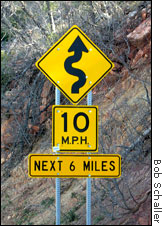
US HIGHWAY 191, ARIZONA— Eastern Arizona is reputed to have one of the curviest stretches of pavement in the continental forty-eight. I set out to see just HOW twisty it is. The route lies between Clifton and Alpine, Arizona, on US-191. From Phoenix, I picked up the route at Clifton. This road trip goes past mining towns, the Blue River Primitive Area, and the White Mountains. The "twisties" begin north of Clifton and mostly end at Hannagan Meadow. Beyond Hannagan, the curves are lazier and the road meanders through the forest the last few miles into Alpine. Clifton and neighbor Morenci are mining towns. Copper mining is a depressed industry, so these towns appear to be slowly dying. But there is history here. Geronimo, the famous Apache war chief, may have been born here, and the dramatic cliffs that surround these towns give ample evidence for the original name: "Cliff Town." I stopped at the old railroad depot, and at the "cliff jail," blasted into solid rock. The plaque nearby says it was "built" in 1881 or 1882, and the first person confined was the guy that blasted it out. Some reward for his labors!
Leaving town, you pass the Phelps Dodge mine. I can't say an open pit mine is beautiful, but this one is impressive. Everything is on a huge scale: the ore trucks, for example, have 10-foot tall tires. It is one of the largest open pit mines in the world, and you can get a bird's eye view from an overlook along the highway. From Morenci, US-191 winds into the mountains. I counted 435 curves between the city limit and the town of Alpine, 92 miles away. There are twice that many lesser curves, what I'd call "directional adjustments." You climb from about 3500 feet to almost 9000 in elevation. The route passes the vast lands of the San Carlos Apache Tribe, the Blue River Primitive Area, and the pine and aspen forests of the White Mountains. Next> The Blue River Primitive Area 1|2 |
|||