Getting
Out There:
RoadTrip News & Views
|
|
A
Sunday Drive in the Texas Hill Country by
Aaron Reed
| After
a late night with friends and a lazy morning recovering,
Aaron Reed had an urge
to get out of the house and go for a country drive. The
relief he sought was vertical: the lush, shadowed valleys
and craggy ridges of the Texas Hill Country. It was a
Sunday drive, and by the end of the day his spirits were
restored by the fresh air, a collection of Burma Shave
signs and a champion maple tree decked out in its first
fall finery. |
 |
|
 |
|
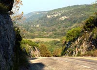
Road
cuts like this one are common in the region; so
are views like this one. |
|
 |
|
 |
|
|
|
|
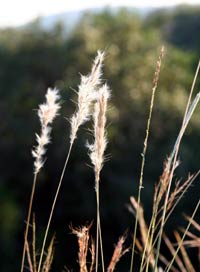
Though
the landscape has been changed since the early
1800s by settlers' land use practices, especially
fire suppression, native grasses still hint at
the vast savannah that once covered the area. |
|
|
|
|
|
|
|
|
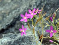
Even
in late summer and early fall, wildflowers like
this natural bouquet of Mountain Pink delight
Hill Country travelers. |
|
|
|
|
|
I was not surprised that the break in the hills
had a name: Bandera Pass. Neither was it much of a stretch
to imagine that the highway followed an old Indian trail known
since the earliest days of Spanish settlement, or that Texas
Rangers -- and later, U.S. Army cavalrymen -- had used the
route. After all, many of the roads that crisscross Texas
follow wagon trails and even older paths, some stretching
back centuries.
I was taken aback, though, to read on the old granite marker
that in 1936 the state historical commission considered the
surrounding peaks "mountains."
Texas has mountains, to be sure. More than 90
of them rise over a mile into the sky, but they are all far
to the west. Here in the Texas Hill Country, in central Texas,
elevations range from around 600 feet to just over 3,000 feet
above sea level -- not mountains, perhaps, but noteworthy
uplifts none the less, especially when you consider how far
these hills roll. Depending on whom you believe, or maybe
how it's measured, the Hill Country covers an area of 37,000
square miles (about the size of Virginia), or maybe 59,000
square miles (Georgia) -- room enough to roam for a week or
more.
But Tamara and I had set out to revive an old
tradition: the Sunday drive. We were seeking relief. After
a late night with friends in our new home and a lazy morning
recovering, we had an urge to get out of the house and go
for a country drive. The relief we sought was vertical: the
lush, shadowed valleys and craggy ridges of those Texas hills.
It's ranching country, mostly. The stony highlands are too
stingy to give up the sorts of crops worth breaking a plow
for, though along the river bottoms and in the valleys, seasonal
floods have deposited enough rich topsoil to grow pecans and
apples and a few other useful things.
We had only a vague plan on that late-September Sunday: to
take in the views along Ranch Road 337 between the town of
Medina and the crossroads hamlet of Vanderpool. The "Ranch
Road" designation, like "Farm-to-Market" and
"Farm Road," signifies a rural state highway, often
only two lanes wide but sometimes four. Often the same numbered
road is designated as both a "farm" and "ranch"
road on alternate signs.
We charted our route as we drove. West on U.S. Highway 290
through Dripping Springs ("Gateway to the Hill Country,"
and just 20 minutes from our front door in south Austin),
then south on Ranch Road 165 at Henley. This road, which leads
to the old town of Blanco (Spanish for "white,"
but locals pronounce it "blane-ko"), offered the
first spectacular Hill Country view as it topped the divide
between the Blanco and Colorado River valleys.
Continued
on page 2>
More
"Getting Out There Articles>
| 